Full Article
about Arenas
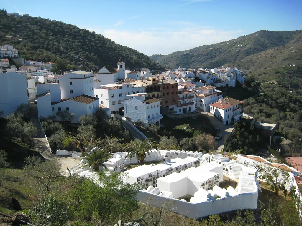
A Moorish-layout village ringed by almond and olive trees, overlooked by the ruins of the Bentomiz fortress.
Hide article Read full article
A village that wakes slowly
At the hour when the sun begins to climb over the hills of the Axarquía, the streets of Arenas are still half in shadow. A car starts somewhere downhill, a broom brushes against the cobbles. Tourism in Arenas rarely arrives this early, and that is precisely when the place makes the most sense: whitewashed houses still holding the night’s cool, the smell of coffee drifting through a half-open window, and that pause before the day properly begins.
Set at around 400 metres above sea level, inland in the Axarquía region of Málaga, Arenas is a small municipality with just over a thousand residents. It is surrounded by an agricultural landscape that shapes everything. From almost any corner there are views of gentle hills covered with olive trees and almond groves, plots divided by dry stone walls, and dirt tracks disappearing between terraces. The countryside is not a backdrop here, it is constant.
Old olive trees, with thick, twisted trunks, stand on slopes that sometimes make each step deliberate. In February the almond trees usually come into bloom, and for a few days the scene shifts completely: patches of white and pink against soil still dark from winter rain.
Wandering the centre
The centre of Arenas is small, but it rewards a slow walk. Streets rise and fall with the irregular logic of villages that adapted to the hillside long before modern planning. In some stretches there is barely room for a car to pass.
At the highest point stands the parish church, dedicated to Nuestra Señora de los Remedios. The building has the restrained look common in many rural churches in the Axarquía: pale walls, reddish roof tiles, and a bell tower visible from much of the village. The current structure is usually dated to the 16th century, built over an earlier hermitage.
Around it are small squares and corners where the details that define the centre come together: slightly rusted iron grilles, rows of plant pots set against walls, wooden doors that creak as they open. By mid-afternoon, as the sun lowers, light slips sideways through the narrow streets and the façades reflect a near golden white.
Arriving by car tends to mean leaving it in the lower part of the village and continuing on foot. The slopes are short but constant, and the layout is not designed for circling in search of a space.
Paths through cultivated hills
Leaving the built-up area leads straight onto rural tracks. Some link with other villages in the area such as Sayalonga, Cómpeta or towards Vélez-Málaga, crossing a landscape shaped over centuries.
Most of these are dirt tracks used by farmers. They are not always signposted for visitors, although they can be followed without much trouble with a map or a route app. There are climbs that make themselves felt, especially in summer when the sun falls directly onto the hillsides.
Along the way there are small tool sheds, terraces supported by dry stone walls, and plots where cultivation continues in a fairly traditional way. During the olive harvest it is common to see trailers, nets spread beneath the trees, and the steady sound of poles striking branches.
Early in the morning or towards the end of the day, the light alters the colours of the land. Olive groves take on a silvery tone, and the houses of the village, seen from below, appear stacked against the slope.
A calendar shaped by the land
Local celebrations tend to follow both the religious and agricultural calendar. At the beginning of September, festivities are held in honour of Nuestra Señora de los Remedios, the patron saint of the municipality. During those days the main square and nearby streets gather most of the village’s activity.
In winter comes one of the most recognisable moments in the surrounding landscape: the almond blossom. It does not happen on exactly the same dates each year, as it depends on cold weather and rainfall, but between January and February many nearby hills fill with pale flowers.
For the rest of the year, life in Arenas follows a steady rhythm. Agricultural cycles set the pace, along with weekends when family members who live elsewhere return.
Reaching Arenas and choosing the moment
From the city of Málaga, the drive usually takes a little over an hour. The usual route heads first towards Vélez-Málaga, then continues along local roads that climb into the interior of the Axarquía. The final kilometres include bends and narrower sections in places.
Spring and autumn are generally the most comfortable times to walk in the area, with milder temperatures and a landscape that shifts in colour. Summer brings strong heat from midday onwards, so earlier starts or late afternoon outings make more sense.
Comfortable footwear is worth considering if planning to explore the old centre or head out along rural tracks. The cobbles and the constant inclines become noticeable after a while.