Full Article
about Tarifa
Southernmost point of Europe and wind capital; kitesurfing paradise with endless beaches and a bohemian vibe
Hide article Read full article
Where the wind meets the Strait
Tourism in Tarifa tends to circle around two constants: the wind and the Strait of Gibraltar. That becomes obvious almost as soon as you arrive. This is not a gentle breeze but the Levante, a strong, persistent wind that shapes daily life, from fishing traditions to sea sports.
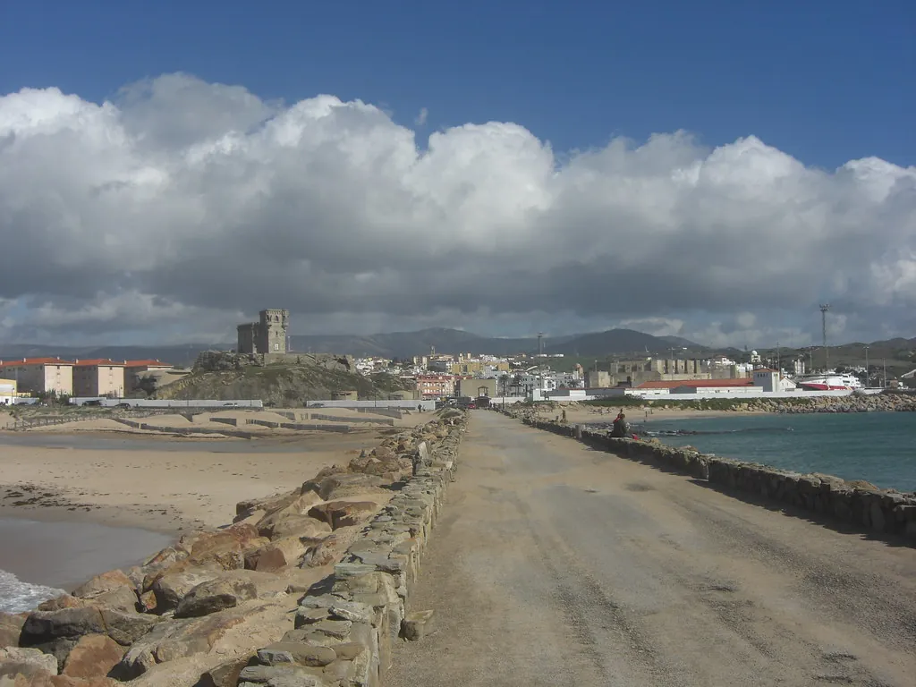
Tarifa sits at the point where the Mediterranean meets the Atlantic. The geography becomes especially clear from the Isla de las Palomas, connected to the mainland by a road. From there, the African coast appears directly ahead, roughly fourteen kilometres away in a straight line. The sense of proximity defines the place as much as the wind does.
A town shaped by its role as a frontier
The name Tarifa is often linked to Tarif ibn Malik, a Berber military figure who reached these shores in the early eighth century. Yet the site was already significant long before that. During the Roman period, the city of Julia Traducta stood here, tied to fish salting industries and maritime trade across the Strait.
A few kilometres away, in the bay of Bolonia, the archaeological site of Baelo Claudia offers a clear view of that Roman world connected to the sea. Its streets, a theatre facing the beach and the remains of salting factories show how the local economy functioned. It relied heavily on garum, a fermented fish sauce, along with other products derived from tuna.
In the medieval period, Tarifa developed primarily as a defensive stronghold. The Castillo de Guzmán el Bueno, begun in the tenth century under the orders of Caliph Abd al-Rahman III, controlled passage through the Strait. The fortress is closely tied to a well-known episode in Castilian history: the siege of 1294. Alonso Pérez de Guzmán refused to surrender the town even under threat to his son’s life. The story of a dagger thrown from the walls belongs more to tradition than documented fact, yet it remains part of the city’s historical narrative.
Tuna, recipes and traces of the sea
Tarifa’s connection to bluefin tuna is still very much alive. Each spring, almadrabas, traditional tuna traps, are set up along different points of the Cádiz coastline. The technique has ancient origins and is often associated with methods introduced during the Islamic period, although its history is likely more complex. The seasonal migration of tuna into the Mediterranean continues to shape the rhythm of many communities along the Strait.
In local cooking, tuna appears in a range of preparations: served raw, lightly seared or cooked in stews. Fried dishes linked to the nearby sea are also common. Across much of the province, tortillitas de camarones, small shrimp fritters, are typical. Along this stretch of coast there are variations made with very small seafood, fried in a light batter.
Sweet dishes reflect an Andalusi legacy. Pestiños are especially common during Semana Santa and in winter. They combine honey, olive oil and fried dough, with a distinctive hint of anise that runs through many Andalusian kitchens.
Long beaches under constant wind
The coastline around Tarifa stretches for many kilometres in long, open beaches. Los Lances, Valdevaqueros and Bolonia all share defining features: wide expanses of sand and frequent wind, with the Strait always in view. From the late twentieth century onwards, these conditions attracted windsurfing enthusiasts, followed later by kitesurfing. The sight of kites over the water has become a regular part of the coastal landscape for much of the year.
Beyond sport, much of the surrounding area is protected. The Parque Natural del Estrecho and the Parque Natural de los Alcornocales cover large sections of the coastline and nearby hills. There are straightforward walking routes close to the sea, as well as others that climb into low mountain ranges where the passage between continents can be clearly observed. On clear days, the Moroccan coast is sharply visible across the water.
Near the site known as the Cueva del Moro, prehistoric cave paintings linked to southern Iberian rock art have been preserved. Dating varies depending on the study, though they are generally placed in later prehistory. These paintings form part of a wider group of shelters in the Campo de Gibraltar area that feature schematic rock art.
Within the walls
The old town of Tarifa retains the irregular layout inherited from its medieval past. Much of the existing wall structure reflects Islamic-period construction, later modified after the Christian conquest. The area is easy to explore on foot.
The church of Santa María stands on the site of what was once the main mosque. The current building reflects several construction phases, particularly between the sixteenth and eighteenth centuries. Nearby streets still reveal stretches of wall, old gateways and houses adapted to the conditions of the Strait. Many include interior courtyards and relatively closed façades facing outward, a practical response to the wind.
During the Peninsular War, Tarifa once again took on strategic importance. Its defences withstood attacks from Napoleonic troops attempting to control maritime access between the Atlantic and the Mediterranean.
Reaching Tarifa and timing a visit
Tarifa lies at the southern end of the province of Cádiz, within the Campo de Gibraltar region. It is reached by road from Cádiz or from the Algeciras area, following a route that runs alongside the Strait. The final stretch hugs the coastline and can become busy during the summer months.
Visitor numbers rise significantly in the warmer part of the year, when the combination of beaches and wind draws both holidaymakers and water sports enthusiasts.