Full Article
about Trebujena
Wine town famous for its grape must and sunsets over the Guadalquivir; film location
Hide article Read full article
Where the Vineyards Meet the Marshes
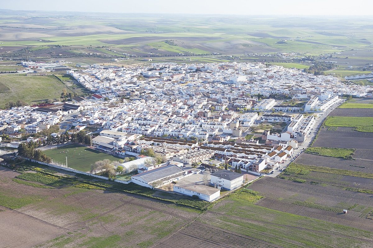
Tourism in Trebujena begins with geography. The town stands on a low hill beside the Guadalquivir, right on the boundary between the vineyards of the Marco de Jerez and the marshes that signal the river’s approach to the Atlantic. From the road that arrives from Sanlúcar, that frontier is easy to read: white albariza soil on one side, and in the distance the flat shimmer of water threading through channels and rice fields.
This in‑between position has shaped local life for centuries. Trebujena is not a seaside town, yet it is not quite inland either. The river, the marshes and the vine have defined its economy and influenced how people relate to the landscape around them.
The Port Without a Coastline
Medieval sources already mention Trebujena as a settlement linked to the Guadalquivir. In the 12th century the geographer Al‑Idrisi referred to it as Tarbasana, placing it along the river route that connected the Strait of Gibraltar with Seville. At that time the river occupied a different space from today. Much of what is now marshland or rice cultivation was once open to navigation.
Over the centuries, sediment carried by the Guadalquivir gradually pushed the navigable water further away. The town’s earlier character as a river port faded into the background. Trebujena turned instead to a more stable resource: the vine.
The hills around the town centre are covered in albariza, the distinctive white chalky soil that defines much of the vineyard area of the Marco de Jerez, the wine region associated with sherry production. In Trebujena, mosto, freshly fermented grape must, has long been central to daily life. It is more than a seasonal drink. For generations it has formed the economic and social backbone of the community. Many older houses still contain spaces once used for small‑scale domestic winemaking, a reminder that production was often family based rather than industrial.
From Alquería to Villa
After the Christian conquest of the Guadalquivir valley, these lands came under the control of the house of Medina Sidonia, one of the major noble families of western Andalusia. For centuries Trebujena was administratively dependent on nearby Sanlúcar de Barrameda.
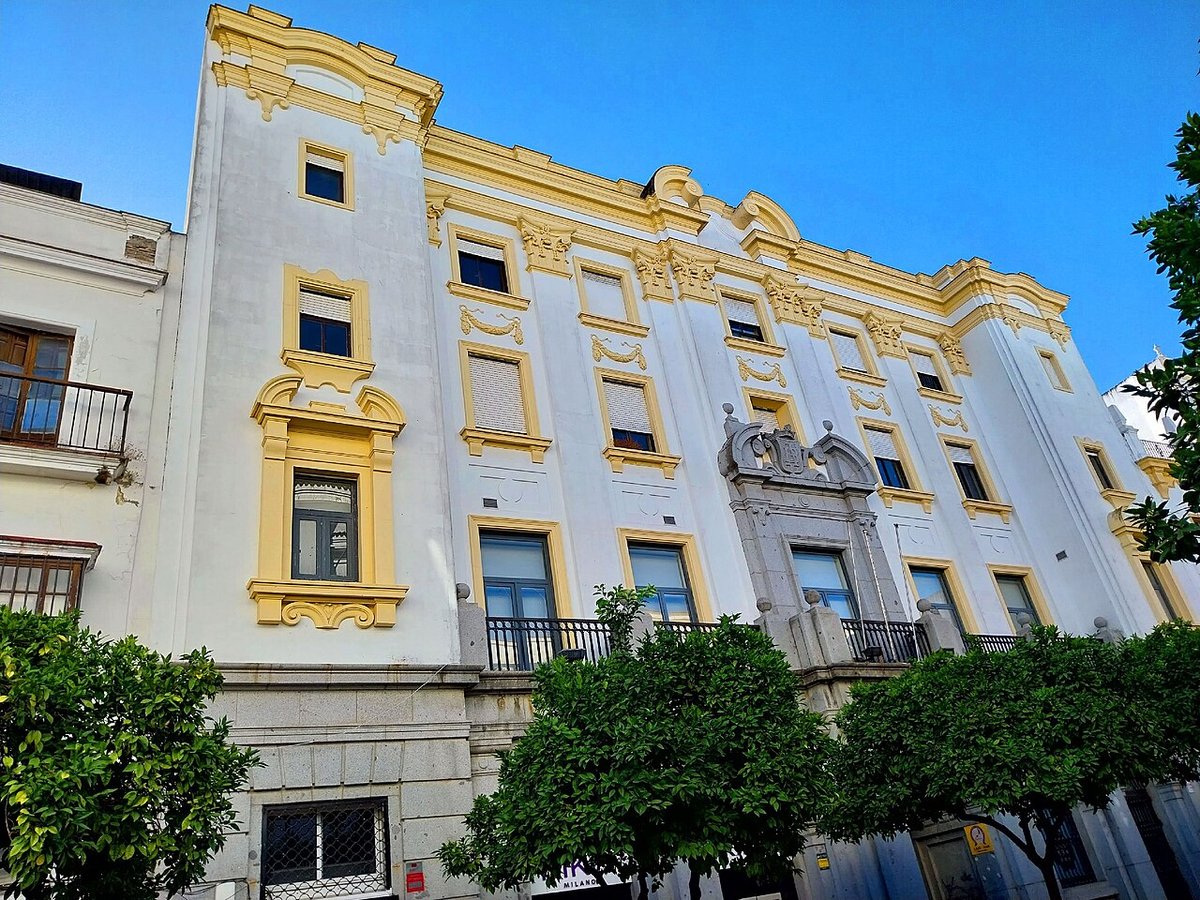
At the end of the 15th century it received a charter of settlement and acquired its own status as a villa, or town with municipal recognition. That shift helps explain part of the civil architecture still visible in the historic centre: large houses connected to agricultural activity and the wine trade.
Among them is the so‑called Casa de los Leones. This early modern building preserves heraldic elements on its façade associated with lineages linked to the area. It is not an urban palace in the style of Andalusian provincial capitals. Instead, it reflects the model of a substantial house tied to landowners and vineyard proprietors, practical yet marked by a certain status.
Mosto and Winter Gatherings
Trebujena’s relationship with wine becomes particularly visible when the new mosto appears. After the grape harvest, the first young wines are produced and consumed here in a direct, almost domestic way.
During winter, the park of La Toya often hosts popular gastronomic gatherings. Neighbours and local associations prepare traditional dishes while tasting the season’s mostos. These are events closely linked to the agricultural calendar, where food and wine serve as a reason to come together rather than as a staged spectacle.
The dishes that tend to appear reflect that seasonal rhythm. Chickpea‑based recipes are common, along with winter stews and other meals shaped by what nearby market gardens and the marshes provide. The emphasis is on shared tables and continuity with rural life.
The Marshes of the Lower Guadalquivir
A significant part of Trebujena’s municipal area extends into the marshes of the lower Guadalquivir. The landscape here is strikingly horizontal, cut through by tidal channels and agricultural tracks. Water levels shift constantly, responding both to the tides and to the management of the rice fields.
In winter it is common to see waterbirds feeding in these wetlands. Avocets, herons and spoonbills use the area as a feeding ground. The open, largely undeveloped character of the marshes has also attracted various film and television shoots, drawn by the sense of space and light.
There are scattered remains of earlier occupations connected to the exploitation of the river. Without archaeological context they can be difficult to interpret, but they point to long‑standing human activity tied to waterways and marshland resources.
Walking Through Trebujena
The town itself can be explored easily on foot. Plaza de España forms the administrative heart, and from here the tower of the church of San Andrés stands out clearly against the skyline.
The current church dates mainly from the 18th century, though like many Andalusian churches it has undergone later alterations. Its presence in the townscape is more striking than its size, anchoring the profile of Trebujena when seen from a distance.
From the square, several streets slope down towards older quarters. Calle Ancha, despite its name, is not especially wide. It links small squares and whitewashed houses where the steady pace of an agricultural town is still evident.
Further downhill lies the park of La Toya. Today it is the principal green space in the municipality, with a bandstand and areas used for community events. From its edges the view opens out towards the marshes and the valley, reconnecting the urban centre with the broad, shifting landscape that has always defined Trebujena.
In Trebujena, the boundaries between river and vineyard, settlement and marsh, feel close at hand. Understanding that meeting point is key to understanding the town itself.