Full Article
about Benitagla
The least-populated municipality in the province; a haven of peace in the Sierra de los Filabres.
Hide article Read full article
A village on the southern slope
Tourism in Benitagla begins with its setting. The village sits on the southern side of the Sierra de los Filabres, at around 950 metres above sea level, spread across a dry hillside that opens towards the valley below. Fewer than seventy people live here. The small cluster of houses follows the slope closely, with narrow streets and short bends that reflect a layout shaped over time rather than planned. This way of building still echoes its Moorish past.
The sense of space is immediate. The hillside is open, with little to interrupt the view, and the village feels closely tied to the terrain it occupies. There is no separation between settlement and landscape. One blends into the other.
Historical and geographical background
Benitagla traces its origins to the Berber presence in the Iberian Peninsula. Its name is often understood as “son of Tagla”, an Arabic reference that appears in several place names across the region. After the Christian conquest in the 16th century, the village continued as a small agricultural community. Life centred on dry farming terraces and modest livestock rearing.
The wider Filabres‑Tabernas area combines relatively high mountain ranges with very arid zones. Around Benitagla, the vegetation reflects these conditions. There are scattered holm oaks and some Aleppo pines planted to stabilise the ground. Low scrub dominates, including thyme and rosemary, plants adapted to limited water. The abandoned terraces surrounding the village hint at a time when agriculture played a larger role than it does today.
This contrast between past and present remains visible in the land itself. The terraces, now largely unused, still mark the slopes in lines that follow the contours of the hills.
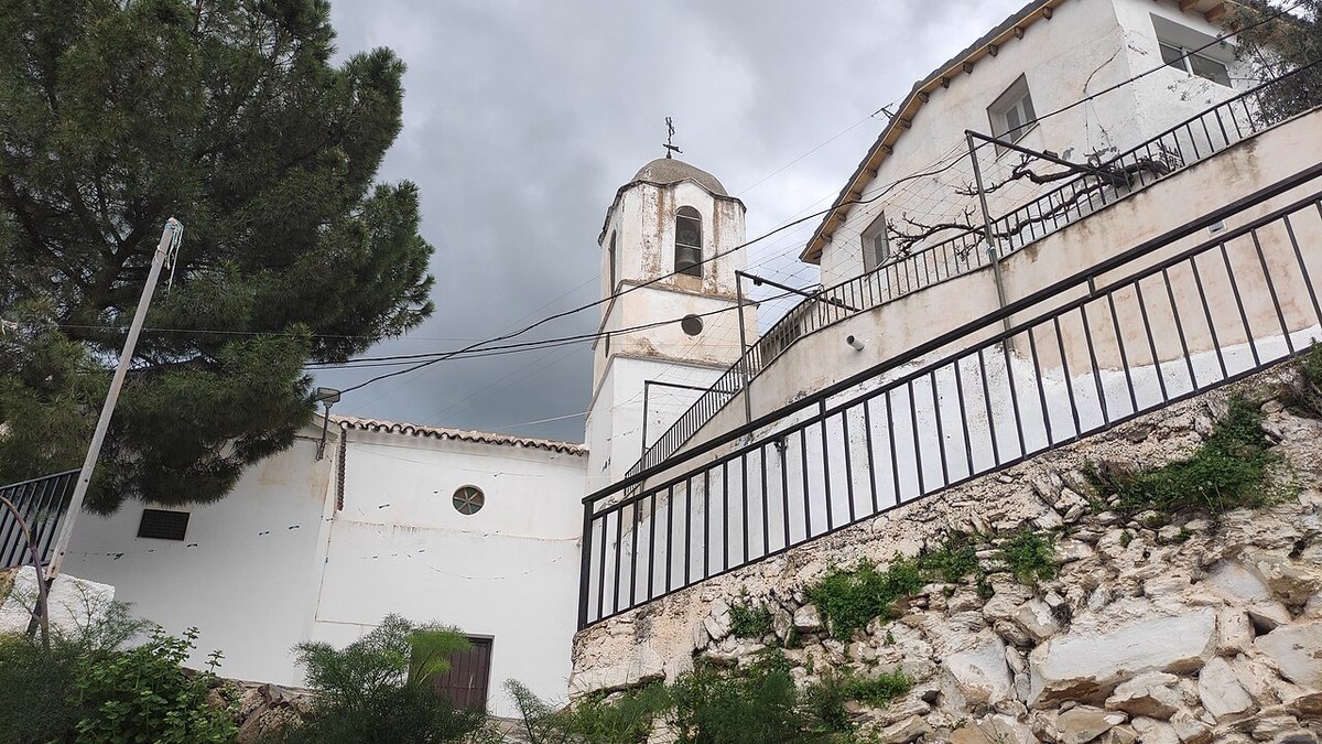
The shape of the village
The centre of Benitagla can be explored quickly. Streets climb and dip with the hillside, without any regular grid. Houses are simple, whitewashed, often with metal window grilles and small patios or roof terraces.
At the heart of the village stands the parish church of the Inmaculada Concepción. The current building dates from the 16th century and was later altered, probably in the 18th century. It is not large, yet its position in the main square gives it a central role in local life. Gatherings and celebrations tend to focus on this space.
Between the houses, there are open points where the surrounding hills come into view. On clear days, it is possible to make out the more arid strip of land that signals the Tabernas Desert in the distance. There are no marked viewpoints. Any street that faces the valley can offer a wide view.
The overall impression is of a place shaped by necessity and continuity. The built environment remains closely aligned with its original purpose, without much alteration.
Paths and the surrounding landscape
The landscape around Benitagla is that of a dry mid-mountain area. Rounded hills alternate with deep ravines, and tracks run along routes that were once used for agriculture.
Several paths and forest tracks start from the village. Many were traditionally used to reach terraces or to move livestock. Signposting is not always present. Those who want to walk in the area usually rely on a map or ask local residents for guidance.
The character of the landscape changes noticeably over the course of the day. In the morning, the shapes of the terrain appear more defined. As the afternoon fades, the ochre tones of the ground become stronger. The village falls into shadow while the valley below still holds the light.
There is little sense of separation between cultivated and uncultivated land here. The old agricultural routes remain part of how the area is navigated, even if their original use has declined.
Local life, food and celebrations
The food associated with Benitagla and its surroundings reflects what the land traditionally provided. Legumes, slow-cooked dishes and homemade cured meats form the basis of the local cuisine. This is not an offer designed for visitors. It is mainly preserved in family gatherings and during local festivities.
The main celebration is linked to the Inmaculada Concepción in December. Processions and religious events take place around the church and the square. Semana Santa is observed in a simple way, with liturgical services at its centre.
In summer, the rhythm of the village shifts slightly. Many residents who live elsewhere return for a few days, and the population increases for a time. There is more movement in the streets and in family homes, though the scale remains small.
Daily life continues to be shaped by long-standing routines rather than tourism. The village does not adapt itself to visitors so much as receive those who arrive.
Getting there and practical notes
From the city of Almería, the usual route heads inland along the A‑92 before turning towards Tabernas. From there, local roads climb up into the mountains. The final stretch is a mountain road, with bends and gradients.
Benitagla is a very small settlement, and tourist infrastructure is limited. Visits are often part of a wider route through the Sierra de los Filabres or nearby villages. It is worth arriving with a clear idea of the journey and allowing time to travel along quiet roads.
The village does not present itself as a destination filled with attractions. Its interest lies in its setting, its form and the way it continues to exist within a landscape that has shaped it for centuries.