Full Article
about Gérgal
Town dominated by its castle and the Calar Alto astronomical observatory within its limits
Hide article Read full article
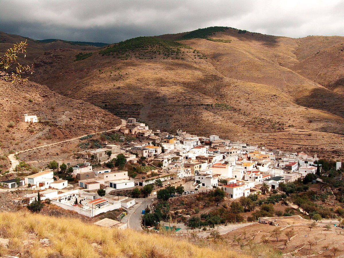
Gérgal: A Village on the Mountain's Edge
Gérgal sits at roughly 700 metres on the southern slope of the Sierra de los Filabres. This isn't a gentle foothill; it's the precise line where the mountain's pine and almond groves break against the arid basin of Tabernas. The village has always been a pass, a place people moved through from the coast toward the interior. That history of transit and tough, dryland farming is written into its compact layout and the architecture of its houses: thick-walled, whitewashed, with small northern windows and interior patios designed for shade.
The population hovers around a thousand. Winters here are colder than the Almerían coast anticipates, and some years, snow dusts the Filabres peaks visible to the north. From certain streets in the upper part of town, you can see that white line against the blue sky, a stark reminder of the altitude.
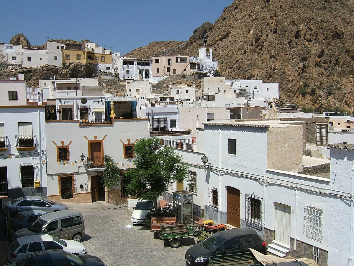
The Castle, the Church, and the Shape of the Town
The village organises itself around two points: a castle and a church. The remains of the Castillo de Gérgal occupy a defensive hill to the east. What stands today is largely a 16th-century reconstruction, built after the Morisco revolt, on older foundations. Its value now is topographic. From its rubble, you see why it was placed here: complete visual command over the pass between the sierra and the dry valleys leading to Tabernas.
Below, the parish church of San Roque dates from the same repopulation period. Its exterior is severe—pale stone, a solid tower—typical of these post-Reconquista foundations meant for function, not flourish. The streets immediately surrounding it are narrow and sloping, forming the old quarter. Look for details in passing: stone doorframes with worn crests, forged iron window grilles, glimpses of shaded patios through wooden gates.
The Plaza de la Constitución functions as the modern centre, with its town hall and benches under trees. Life here follows the slower tempo common to villages in this region.
A Landscape in Transition
The geography here is a study in contrast. Walk north from the village, and the land climbs into the Filabres, with deeper soil supporting patches of pine and larger almond groves. Walk south, and within a kilometre the terrain begins to shed its greenery. The earth turns pale, vegetation shrinks to tough esparto grass and thyme, and the hills become deeply scored by erosion.
A fifteen-minute drive south plunges you fully into the Desierto de Tabernas. The shift is not gradual; it is a sudden drop into a different world of badlands and dry riverbeds. The light becomes intense, almost tangible.
Paths and Practicalities
A network of rural tracks and old livestock trails extends from Gérgal. One short, clear path leads directly up to the castle. Others head into the sierra or trace the edges of agricultural plots. Signage is inconsistent; it's wise to confirm route conditions locally if you plan a long walk. The most revealing walks are those that follow the contour lines east or west of the village, where you can observe the slow transformation of the landscape from mountain to desert.
The light defines these walks. In the middle of the day, the sun flattens everything. Go early in the morning or late in the afternoon, and the low angle throws the ridges of the sierra and the wrinkles of the badlands into sharp relief.
Local Rhythms
The annual cycle is marked by agriculture—mainly almonds and olives—and two focal points in the calendar. The fiestas patronales for San Roque occur in mid-August, transforming the plaza with public dances and a communal shift in pace. Semana Santa is observed more intimately, with processions winding through the tight streets of the old quarter.
Gérgal is about 35 kilometres from Almería city, accessed via the A-92 and connecting regional roads. While there is a bus service, its frequency is limited. Having a car is virtually essential for reaching the village and for exploring its surroundings.
The climate is continental Mediterranean: hot in summer, cold in winter, with sharp temperature drops at night. Sun protection and water are necessary for any excursion, regardless of season. This is not a lush landscape; its appeal lies in its clarity, its stark lines, and its position on a visible frontier between two terrains.