Full Article
about Vejer de la Frontera
Walled white hill town with unmistakable Moorish charm; ranked among Spain’s most beautiful villages.
Hide article Read full article
A hilltop shaped by its past
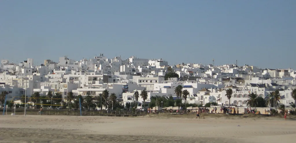
From the road that climbs up from the Barbate river, Vejer de la Frontera appears as a white patch suspended above the plain. The town clings to a hill of around two hundred metres and looks out towards the Strait. Its position, between the Atlantic coast and the countryside of La Janda, helps explain much of what stands here today: defensive walls, a castle, a former mosque turned church, and watchtowers that once monitored the shoreline. Even the long-standing importance of tuna in the area is tied to this geography.
Height as protection
Vejer’s setting is not accidental. It is strategy in physical form. Tuna fishing was already established near the mouth of the Barbate in ancient times, yet it was under Muslim rule that the settlement took shape at the top of the hill. From there, routes between the coast and the inland areas could be controlled with ease.
For more than five centuries, Vejer formed part of al‑Ándalus. Much of the current layout dates back to that period. Streets run narrow and irregular, climbing and dipping with the terrain. Whitewashed walls reflect the light intensely, and houses are arranged around interior courtyards, designed to keep daily life sheltered from heat and outside view.
After the Castilian conquest in the 13th century, the town became linked to the Order of Santiago. That connection hints at its continued importance in a territory that remained a frontier for some time.
At the highest point of the historic centre stands the castle. What can be seen today is the result of several stages of construction. Some elements are clearly of Islamic origin, such as a horseshoe arch associated with an earlier प्रवेश, while later modifications altered the structure over time. It is not an imposing fortress, yet it offers a clear sense of how defence worked here: a main tower, an inner courtyard, and walls that blend into the surrounding houses. From this vantage point, both the coastal routes and the inland paths of La Janda come into view.
Among the entrances to the walled enclosure, the Puerta de Sancho IV is the best preserved. Over the centuries it has served different purposes, including a period as the municipal jail, a use that was common for buildings of this kind.
A town tied to the sea
Vejer has never been a port, yet its connection to the sea has always been close. A few kilometres away, in Barbate, the almadraba has captured bluefin tuna for centuries during the spring migration. This seasonal activity generated wealth that reached the hilltop town.
Between the 16th and 17th centuries, a chain of watchtowers was built along the coast to warn of incursions from the sea. These towers formed part of a wider surveillance system that extended along much of the Cádiz coastline. When suspicious sails appeared, signals of smoke or fire would alert settlements further inland.
The nearest stretch of coast today is El Palmar, only a short distance away. Although it belongs administratively to the municipality of Vejer, its development is far more recent. From the late 20th century, it began attracting people connected to surfing, partly because the area remained largely undeveloped for a long time and offered an extended beachfront. During summer it takes on the feel of a separate hub, while the historic centre of Vejer keeps a slower rhythm.
Streets that turn inward
Walking through Vejer reveals an architecture designed as much for privacy as for climate. Many houses conceal interior spaces behind solid wooden doors. Inside, there are courtyards with plants, wells, or old cisterns. This reflects a clear Andalusi influence, where domestic life unfolds inward and the street is mainly a place of passage.
In spring, some of these patios open to the public during days organised by the local council. It is a rare chance to see how these homes are structured from within.
The Arco de las Monjas offers a good example of how space is used in the town. It is a narrow passageway linking two parts of the old quarter, originally connected to convent buildings. Covered passages like this are common in walled towns where space was limited and every corner had to be used carefully.
Plaza de España acts as the centre of daily life. Its tiled fountain, built in the 20th century, became widely known after appearing in a television advertisement. Beyond that, it remains a meeting point and a place people pass through as part of their routine.
Just outside the town, a few kilometres away, stands the sanctuary of Nuestra Señora de la Oliva. Devotion to this figure runs deep in the area. At certain times of year, the image is traditionally brought into Vejer, forming one of the most important celebrations in the local calendar.
Wind and the Cobijada
The levante wind is part of everyday life in Vejer. It can blow strongly at certain times and shapes everything from agriculture to how outdoor spaces are used.
It is also linked to a distinctive garment known as the Cobijada. This black cloak covers almost the entire face and body, leaving only one eye visible. For a long time, it served a practical purpose. Women used it to protect themselves from sun, dust, and wind when moving through the countryside or around the town.
The Cobijada remains one of the most recognisable symbols of Vejer. It reflects how local customs adapted to the environment, just as the town itself adapted to its hilltop setting.
Vejer de la Frontera is defined by its position, its layered past, and the ways in which daily life has responded to both. The walls, the inward-facing houses, the connection to the sea, and even the force of the wind all contribute to a place where geography and history are closely intertwined.