Full Article
about Cuevas del Almanzora
Historic mining and manor town; it has a coastline
Hide article Read full article
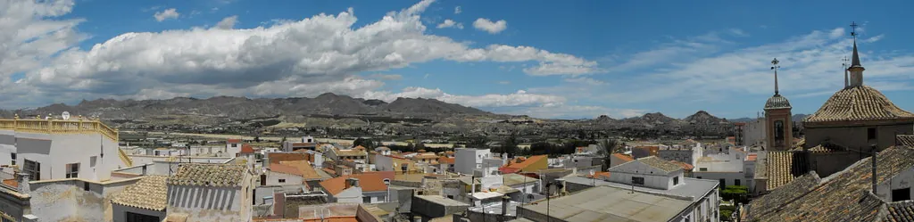
Tourism in Cuevas del Almanzora makes most sense when viewed through its landscape. The town stands at the lower end of the Almanzora river valley, where the fertile plain begins to open towards the eastern coast of Almería and the scenery turns noticeably drier. Agriculture, mining and proximity to the sea all meet here. That combination explains why a medium-sized municipality contains a Renaissance castle, neighbourhoods carved directly into the hillside and traces of a 19th-century mining boom that shaped its history.
The district of Cuevas del Calguerín begins where the main urban area thins out along the slope. Around two kilometres from the centre, tarmac gives way to unpaved streets and whitewashed façades that are in fact the fronts of homes dug into the earth. Several hundred caves are counted on this hill. Many were adapted as dwellings in the 19th century, when the population grew alongside mining activity in Sierra Almagrera.
Residents often repeat the same point about these homes: the temperature remains relatively stable throughout the year. In summer they stay cool. In winter they feel mild, thanks to the thickness of the surrounding earth.
The Castle That Shapes the Town
The skyline of Cuevas del Almanzora is defined by the castle of the Marqués de los Vélez. This fortress was built at the beginning of the 16th century, in the years following the Castilian conquest of the Kingdom of Granada. It was less a stronghold designed for major sieges and more a symbol of seigneurial power, as well as a way to control the valley below.
Its square parade ground, highly regular in layout, makes that representative role clear. Today the building houses the Museo Antonio Manuel Campoy, created from the collection assembled by the art critic born in this region. Inside are works by 20th-century artists that can come as a surprise in this setting, including pieces by Picasso and Miró.
A short distance away stands the church of Nuestra Señora de la Encarnación. The current building dates from the 18th century, probably constructed over earlier structures linked to the former mosque. The scale of the interior is striking on entering. The nave is among the widest in the province. From the area around the castle, the town’s position becomes clear, with the fertile Almanzora plain stretching inland.
The Silver Memory of Sierra Almagrera
In the mid-19th century, the discovery of veins of argentiferous galena in Sierra Almagrera sparked one of the great mining rushes in south-eastern Spain. Foreign investors arrived, along with technicians from different parts of the country. Deep shafts were sunk and transport systems were organised to carry the ore to the coast, above all towards the port of Águilas.
The boom was short-lived. By the end of the century, falling silver prices and the exhaustion of certain veins led to swift closures. In the sierra, wells, spoil heaps and remains of installations still mark that period. After heavy rain, a whitish film sometimes appears on the ground, associated with minerals that surface.
Down on the plain, the landscape returns to agriculture. Olive groves occupy some of the most fertile plots, alongside irrigated crops. The Cuevas del Almanzora reservoir, built in the final third of the 20th century, altered water management across this part of the valley. Farmers often speak about the need to mix water from different sources to balance salinity in certain crops.
Oven and Mortar Cooking
The local kitchen remains closely tied to the area’s rural and mining past. Olla de trigo is one of the dishes most associated with Cuevas del Almanzora. It is made with wheat grain, pulses, pork and cured sausage, and requires several hours of slow cooking. It was a meal for long working days, common among farm labourers and also among miners in the sierra.
Ajo colorado appears mainly in the colder months. This thick soup relies on paprika and garlic for its flavour and is often finished with boiled egg. In baking, rosquillos de anís and other fried sweets made with olive oil are especially present at family celebrations and on significant dates in the calendar.
Caves Still Lived In
Although many caves have been altered or converted into second homes, part of the Calguerín district remains inhabited. In one of these dwellings, a small ethnographic space was set up some years ago to recreate how these homes once looked. Iron beds, a wood-fired stove and everyday tools help convey daily life inside.
Explanations there tend to focus on roof maintenance. Traditionally, the ceiling was reinforced from time to time with mixtures of earth, straw plus water. Outside, washing lines and small patios adapt to the slope of the hillside, showing that these are not relics but lived-in spaces.
Finding Your Bearings
Cuevas del Almanzora lies beside the Mediterranean motorway, a few kilometres from the coast and close to towns such as Vera and Garrucha. The castle and the church are located in the historic centre and can be explored on foot without difficulty.
To understand the town, it helps to combine that walk with a visit to the caves of Calguerín and an excursion towards Sierra Almagrera. Between the river valley, the mining remains and the hillside homes, the different layers of Cuevas del Almanzora come into view.