Full Article
about Cala
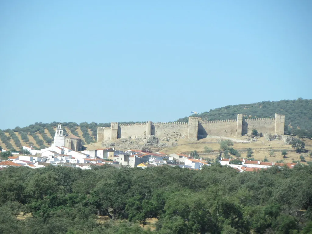
Bordering Extremadura in the natural park; it has a medieval castle and a mining past etched into its landscape and buildings.
Hide article Read full article
Where the Sierra Begins
Tourism in Cala starts with its position on the map. The municipality lies at the northern tip of the province of Huelva, at the western gateway to the Sierra de Aracena. At around 588 metres above sea level, the village stands in a transition zone between the mountains and the first open dehesas that stretch towards Extremadura. Today, roughly 1,100 people live here.
The urban centre grew without major planning. Streets follow a gentle slope, lined with whitewashed houses and corrals that almost touch the surrounding countryside. The dehesa reaches right up to the edge of the village, which is typical in this part of the sierra. Cala is not defined by tourism. Daily life still revolves around the countryside and livestock farming.
The nearby Parque Natural Sierra de Aracena y Picos de Aroche shapes much of the landscape. Holm oaks, cork oaks and livestock estates dominate the surroundings. The Iberian pig has been raised here in extensive systems for centuries, roaming freely across pasture and woodland. That close relationship between woodland and animal husbandry remains the economic backbone of many villages in the region.
Parish Church and Everyday Architecture
The Iglesia parroquial de la Concepción occupies one of the central points of Cala. Built in the 16th century, the church includes Mudejar elements that can still be recognised in its structure. It is not a monumental building. Its interest lies in its continued use and in the way it organises the square in front, a meeting place for generations.
Narrow and slightly irregular streets spread out around it. Their layout reflects the village’s organic growth rather than any geometric plan. Some houses still display stone doorways, old iron grilles and interior patios that once served as spaces for domestic work.
Traditional architecture here shares features common across the sierra. Walls are thick, façades are whitewashed and roofs slope to cope with rain. In older homes, south-facing corridors or galleries make the most of winter sunlight. These details speak to a practical approach to climate and rural life rather than stylistic ambition.
The Dehesa and the Rivera de Cala
The municipal area forms part of the characteristic landscape of the natural park. The dehesa covers almost all the territory. Scattered holm oaks, open pasture and fenced grazing land set the rhythm of the terrain.
These spaces support notable biodiversity. Large birds of prey are often seen circling overhead. Some species use these sierras as feeding grounds or as stopovers during seasonal movements. The mix of open woodland and low scrub creates varied habitats within a relatively small area.
The Rivera de Cala runs through the municipality and shapes parts of the landscape near the village. It is not a large river, yet it creates pockets of denser vegetation along its course. In autumn, chestnut groves in the nearby sierra change colour and draw many visitors from across the province. The seasonal shift is one of the most visible transformations in the surrounding countryside.
Rural Paths and Local Produce
Rural tracks lead out from Cala towards other areas of the sierra. For decades, many of these routes were used to move livestock or to connect estates. Some now serve as walking or cycling routes, though their original purpose remains evident in their layout and surface.
Birdwatching has a modest presence in the area. The combination of open dehesa, scrubland and low mountain ranges produces a variety of habitats. At certain times of day, species typical of the south-west of the Iberian Peninsula can be observed.
Local cooking centres on Iberian pork and products from the surrounding countryside. Wild mushrooms appear in season. Chestnuts feature in autumn. Traditional cured meats continue to form part of the everyday diet in many households. The link between what is raised or gathered in the landscape and what appears on the table remains direct.
A Calendar Rooted in the Village
Celebrations in Cala retain a distinctly local character. The feast of the Virgen de la Concepción at the beginning of December is one of the main dates in the calendar. Residents who live elsewhere often return to the village for these days.
Summer brings open-air dances and activities in the streets. Long evenings make it possible to use squares and open spaces that lie quiet during the heat of the day.
The matanza del cerdo, the traditional pig slaughter, is less widespread than it was decades ago, yet it still takes place in some homes during winter. Rather than a public festival, it is collective work that preserves long-standing methods of curing and conserving meat. Techniques are passed down within families, closely tied to the annual cycle of livestock rearing.
Practical Notes for Visiting
Cala lies about 70 kilometres from the city of Huelva. Access is via regional roads that cross the sierras and dehesas of the northern province.
The village itself can be explored on foot without difficulty. Proper footwear is advisable for the surrounding countryside. Many paths are unpaved and can become muddy after rain. Beyond that, visiting Cala involves walking and paying close attention to the landscape. Life here moves at a slower pace than in other parts of the sierra, shaped more by seasons and agricultural routines than by visitor schedules.