Full Article
about Encinasola
The northernmost municipality in Huelva, bordering Portugal and Extremadura; a land of smugglers and rugged landscapes rich in wildlife.
Hide article Read full article
Tourism in Encinasola
Some places appear on the map almost by accident, the sort you reach after taking the wrong exit on a motorway and deciding to carry on “just to see what’s there”. Tourism in Encinasola works a bit like that. It is rarely anyone’s main destination when travelling through the Sierra de Aracena. Yet once you arrive, it quickly becomes clear that there is more substance here than first impressions suggest.
Encinasola sits on that unusual edge where the province of Huelva almost touches Sevilla and Badajoz. Just over a thousand people live here. The streets rise and fall in the way old town centres often do, built at a time when urban planning meant constructing wherever space allowed. At first glance the village can seem serious, even slightly austere. Walk a little further and the long history of the border begins to show in small details: in the paths around the village, in the stories people tell, in the way open countryside presses close to the houses.
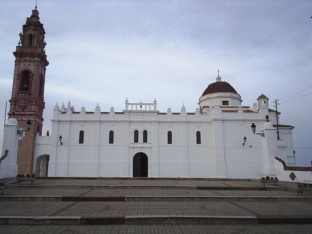
The Heart of Encinasola: History in Stone and Earth
The centre of the village has the feel of a place that has grown at its own pace, like a family home altered when necessary rather than redesigned to follow fashion. The Iglesia de San Andrés, built between the late 16th and early 17th centuries, stands out with its sober tower. It looks constructed to endure rather than to impress. Gothic features mix with Renaissance touches. Visitors do not usually spend long here taking photographs, yet the church helps explain how Encinasola has evolved over the centuries.
The old quarter is compact. A slow walk of around half an hour is enough to see it, much like a short stroll after lunch to stretch your legs. Narrow streets, whitewashed houses and steady slopes encourage an unhurried pace.
Plaza de la Constitución acts as the village’s living room. Benches sit beneath orange trees and olive trees. Neighbours stop to talk. People linger for a while after work. Nothing about it is grand, but spending a little time here reveals how the place moves and breathes.
On the walls of the former Franciscan convent, now used for cultural purposes, traces of old cloisters and earlier structures remain visible. They do not demand attention. Instead, they resemble the marks left on an old wall after repeated alterations, quiet reminders of how many times a building has been reshaped over the years.
A Landscape That Tells Its Own Stories
Encinasola lies within the Parque Natural Sierra de Aracena y Picos de Aroche. The landscape here functions like a vast, unhurried larder: dehesas of holm oak and cork oak spread across the countryside, livestock moves slowly through the fields, and Iberian pigs forage beneath the trees.
The banks of the river Múrtiga offer several stretches suitable for gentle walks. These are simple paths, the sort you can follow almost without noticing the effort, accompanied by the sound of water and birdsong. This is not a place that overwhelms at first sight with dramatic canyons or famous waterfalls. It feels more like a walk through the countryside with someone who knows the area well. The longer you look, the more details you notice.
Simple Routes with a Long Memory
Local routes are generally neither long nor technical. Many follow ancient paths once used when travelling between villages meant hours on foot.
The Ruta de los Molinos passes through areas where water once powered millstones to grind grain. Remains still appear here and there, half hidden by vegetation: sections of wall, old channels, low ruins. They resemble scattered parts of an old mechanism whose function you can still imagine.
The so-called Sendero del Contrabandista recalls a time when the nearby border generated all sorts of stories. Discreet paths through the hills allowed goods to move, or people to avoid official controls. Today these routes are peaceful. Picture them a century ago, though, and the atmosphere changes completely.
Autumn brings another familiar activity in the area: mushroom foraging. Small groups often walk slowly beneath the holm oaks, eyes fixed on the ground with the concentration of someone searching for coins in sand. Caution is the rule here. People usually head out with someone who can confidently distinguish edible varieties.
In the village’s traditional shops, products from the surrounding countryside are easy to find. Jamón ibérico, goat’s cheese and local honey reflect the character of the landscape. There is no need for a complex food itinerary. Sometimes it is enough to step into a shop where the counter appears unchanged for decades.
At night, something curious happens. Step a little beyond the built-up area and look up. The sky fills with stars in a way that recalls switching off all the lights in a room and suddenly noticing how bright the television screen looks. Limited surrounding light makes a real difference, and for that reason some astronomy enthusiasts come to this part of the region.
Festivities with a Border Spirit
The fiestas patronales, held around San Andrés at the end of November, are usually marked with simplicity. Processions move through the streets. Neighbours gather outdoors. Shared meals feel closer to a community celebration than to a large-scale event designed for outsiders.
The border character of Encinasola still shapes its identity. This is a place where geography has long influenced daily life, from trade routes to the stories passed down through generations. That atmosphere remains present, though in quieter ways than before.
Encinasola may not headline travel itineraries for the Sierra de Aracena. It does not rely on spectacle. Its appeal lies in gradual discovery: a church tower built to last, a square that functions as a communal sitting room, old mill walls hidden among plants, pigs roaming beneath oak trees, paths once used in more complicated times. Spend a little time here and the initial impression of austerity gives way to something deeper and more human.