Full Article
about Arcos de la Frontera
Gateway to the White Villages Route, set on a dramatic cliff; historic-artistic ensemble of great monumental and scenic value.
Hide article Read full article
A town shaped by its cliff
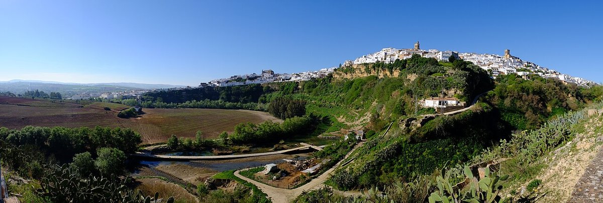
The castle appears before the town itself. From the road that climbs up from the Guadalete, the outline of the old alcázar cuts across the sky like a stone prow. Below it, white houses stack up on a rock more than 180 metres high, while storks settle on towers and bell gables. Arcos de la Frontera quite literally stands on the edge of the cliff carved by the river, and that position explains almost everything: its past, its layout, and the way it is explored today.
The choice of this site goes back a long way. The Romans already occupied this promontory, often referred to in sources as Arx-Arcis, to control movement through the Guadalete valley. The decisive period came later, during al-Andalus. After the fragmentation of the Caliphate of Córdoba in the 11th century, Arcos became the centre of a small taifa that governed much of what is now known as the Sierra de Cádiz. Remains of that era still appear in stretches of wall embedded between houses and in the irregular street pattern that follows the logic of a medina.
Castilian conquest arrived in 1264 under Alfonso X. From that point the town took the name Arcos de la Frontera, a label shared with other places along the former boundary between Christian and Muslim territories. The old Islamic alcázar was converted into a feudal stronghold and later linked to the house of the Ponce de León, who became dukes of Arcos in the late 15th century. The castle remains privately owned, something unusual for a fortress of this kind.
Streets along the precipice
Walking through the historic centre largely means following the contours of the rock on which the town sits. Streets are narrow, with steep stretches and sudden turns that respond more to the terrain than to any formal plan. In several places, houses rest directly on the rocky edge.
Calle Nueva serves as one of the main approaches into the old quarter. Its present layout is linked to rebuilding works after the Lisbon earthquake of 1755, which damaged many buildings in the area. The tower of the church of Santa María, for example, had to be reconstructed after suffering from that event.
The Balcón de la Peña Nueva offers a clear sense of Arcos’s position. From here, the Guadalete loops around the base of the promontory, and the fertile plain stretches out to the east. Storks are often seen occupying the highest towers in the historic centre, a detail that stands out particularly well from this viewpoint.
The Basílica de Santa María de la Asunción stands on the site of a former main mosque. The current building brings together Gothic, Renaissance and Baroque phases. Its 16th-century altarpiece draws much of the artistic attention inside. Not far away is the church of San Pedro, whose Baroque tower is easily recognised from different parts of town. Inside are relics brought in the 18th century, which for a time attracted small local pilgrimages.
Two levels, one town
Arcos today is divided into two clearly distinct areas. Above lies the historic core, compact and shaped by the terrain. Churches, old palaces and tightly packed streets dominate here, with limited space for vehicles. Below, on the flatter land of the vega, the modern town has developed: wider avenues, residential districts and most of the services for a population of more than thirty thousand.
Religious celebrations continue to link these two levels. During Semana Santa, brotherhoods process through the steep streets of the old quarter before descending towards the more open spaces below. The contrast between the narrow upper streets and the broader squares beneath forms part of the character of these events.
At the end of September, the fair associated with San Miguel takes place, traditionally tied to the agricultural calendar. In summer, the romería of the town’s patron saint, Nuestra Señora de las Nieves, brings residents together in the surroundings near the river and in nearby countryside.
Inland cooking with a coastal echo
Local cooking reflects Arcos’s position between countryside and hills. Pork has long been central to domestic food traditions, which explains the regular presence of chicharrones and other products linked to traditional slaughter.
At the same time, some dishes hint at the proximity of the Bay of Cádiz. Tortillitas de camarón, now found across the province, are a clear example. In terms of sweets, convent traditions carry weight: desserts made with egg, syrup or honey remain common, including tocino de cielo and pestiños, especially prepared for specific dates in the calendar.
Along the Guadalete
Arcos often serves as one of the gateways to the Sierra de Cádiz and the so-called Ruta de los Pueblos Blancos. Even so, spending time in its immediate surroundings makes sense.
At the foot of the promontory, the presence of the Guadalete defines the landscape and offers a different perspective on the town above. The relationship between river, fertile plain and elevated settlement becomes especially clear here, rounding out the sense of a place shaped as much by geography as by history.