Full Article
about Carcabuey
Heart of the Sierras Subbéticas Natural Park, dominated by an Arab castle and ringed by limestone peaks and mountain olive groves of high ecological value.
Hide article Read full article
A village beneath its castle
The castle comes into view before the village itself. From the road climbing up from Priego, the outline of the fortress, of Andalusi origin around the 9th century, cuts across the ridges of the Sierras Subbéticas. Tourism in Carcabuey begins up there, because the place makes more sense from that height: defence first, houses later.
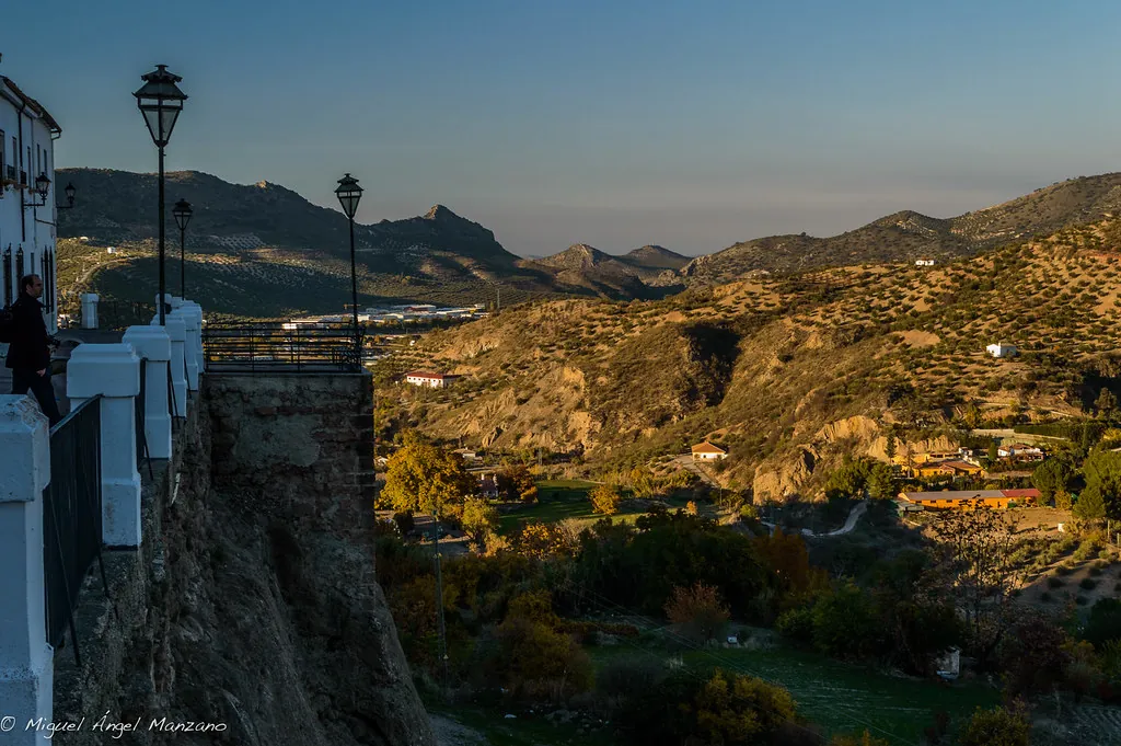
The village sits at about 650 metres above sea level, on the western edge of the Subbética range. The terrain sets the rules. Limestone crags, short slopes and very little room to expand. That is why the old quarter keeps an irregular layout, shaped by the incline. Some streets suddenly narrow, others end abruptly against rock. In several spots, the village opens out into small natural viewpoints looking across the valley.
Layers of stone and story
The castle is sometimes called “de la Traición”, linked to an episode preserved in local tradition. According to that story, in 1282 Nuño Tello killed his daughter there to honour a vow of loyalty to Alfonso X. It is difficult to separate historical fact from what has been passed down over centuries, yet the legend reflects something that does fit the setting: for much of the Middle Ages, Carcabuey was frontier territory.
Before the Christian conquest in 1225, the area had seen Roman occupation. Sources refer to the municipality of Flavio Ipolcobulcula during the imperial period. There are even signs of earlier Iberian presence. On the hill where the castle stands, remains from different periods overlap, which is common in defensive sites that continued to be used across centuries.
The current structure largely reflects later Christian alterations. A cistern, usually dated to the 14th century, still survives, along with stretches of wall and rectangular towers. From the top, much of the Subbética landscape lies open. The limestone terrain forms a sequence of pale ridges, while olive groves spread across the gentler ground.
When the village turns purple
Holy Week in Carcabuey has a distinctive feature: the purple tunics worn by the brotherhoods. Locally, participants are known as “los Moraos”. The tradition is often placed in the 17th century, although its exact beginnings are not always clear.
The colour is explained here as being linked to dyes once used in the area before the expulsion of the Moriscos. This idea appears in local accounts and is often repeated, even if clear documentation is not always available.
Processions pass through the narrow streets of the old quarter. The sound of drums echoes off stone and whitewashed façades. In the early hours of Good Friday, the atmosphere becomes especially restrained. The Cristo de la Vera Cruz moves through the village with minimal lighting, just torches and a few drums setting the pace.
Cooking from the edges of the land
Traditional cooking reflects the surroundings closely. Olive groves cover much of the municipality, so for a long time people relied on what grew beyond cultivated fields.
Tagarninas, for example, grow among rocks and embankments. They are cooked with chickpeas and pork products in substantial winter dishes, suited to long working days.
Local variations of familiar dishes from the province also appear. Flamenquín can be made with goat meat instead of pork, which changes the flavour noticeably. During the grape harvest, fresh grape must is still consumed in its unfermented form during the first days after pressing.
Paths that reveal the landscape
The routes around Carcabuey help explain how this land has been used over time.
The path leading up to the castle partly follows an old bridleway. In some sections, deep marks remain in the rock, worn by the repeated passage of carts and animals.
Another well-known route is that of the Choclaeros. It leads to several rock shelters where prehistoric schematic paintings have been recorded. The figures are simple: archers, animals and signs. They suggest that these hills were already used as grazing land thousands of years ago.
The name of the path recalls those who gathered “choclos”, dry wood used to make charcoal. This was a common activity in the mountains until well into the 20th century.
Finding your way around
Carcabuey lies in the south of the province of Córdoba, within the Sierras Subbéticas Natural Park. It is reached by a regional road from Priego de Córdoba, with a final stretch that winds through olive groves.
The old quarter is easy to explore on foot, although there are short climbs and some cobbled streets. In a couple of hours, it is possible to walk from the main square up to the castle and back at a relaxed pace.
On Tuesdays, a market is usually set up in Plaza de Andalucía. Stalls offer produce from the surrounding area, including cheeses, honey and cured meats from nearby villages.
At the beginning of September, a romería takes place, a traditional pilgrimage that heads up towards the ento...