Full Article
about Agüero
Hide article Read full article
Where the landscape suddenly shifts
There is a moment on the road to Agüero when everything changes. The route runs quietly through fields and gentle bends, and then the scene transforms. Rising behind the village are the mallos, vast reddish rock walls that look almost deliberately placed, as if part of a giant stage set. Tourism in Agüero revolves around this contrast: rock, stillness, and a small village moving at its own pace.
With just over a hundred residents, there is no traffic to speak of and no continuous line of shopfronts. What you notice instead is the wind coming down from the rock faces and the occasional sound of a door closing along the steep streets. Agüero sits in the Hoya de Huesca, not far from the Gállego valley, and feels like a quiet threshold to a landscape that turns wilder than expected in this part of Aragón.
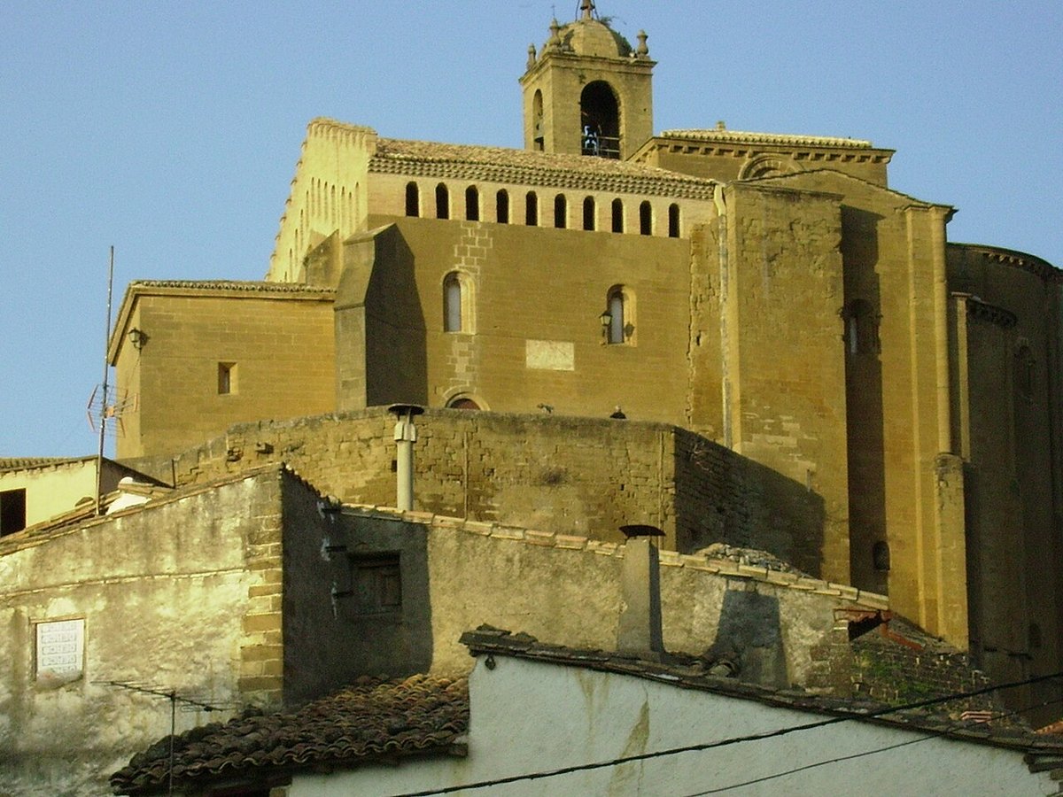
The most recognisable image is the Romanesque church of Santiago, standing right at the foot of the mallos. Built in the 12th century, it reflects the sobriety typical of Aragonese Romanesque architecture: pale stone, simple forms, and capitals carved with biblical scenes and plant motifs. On clear days, looking up from the church towards the rock wall behind it creates a striking composition.
Around it, houses built in sandstone cluster together, many of them well preserved. Some still display coats of arms on their façades and carefully worked doorways, reminders that the village once had more activity than it does now. From the edges of the old centre, the view opens towards the Gállego valley and, when the weather allows, the distant white line of the Pyrenees.
Santiago, the castle remains and a quieter corner of village life
The church of Santiago is worth lingering over. It is not large or heavily decorated, but its setting and proportions give it a strong presence. The carved capitals reward a closer look, each one telling a different story.
Access to the interior is not always guaranteed. As in many small villages, it depends on local schedules or organised visits, so it is sensible to check in advance if going inside matters.
Above the village lie the remains of the old castle. It is no longer a complete structure. What survives are traces and scattered walls, enough to suggest its former role. Walking up to this point helps make sense of the location. From here, the valley and natural access routes can be seen clearly, which explains why the site once held strategic importance.
Not far from the main settlement is the ermita of the Virgen de los Remedios. The setting is calm, with stone crosses and a small fountain nearby. It is one of those places where local traditions still feel present in everyday life, rather than something staged for visitors.
The mallos of Agüero: rock on a grand scale
The mallos are the main reason many people arrive in Agüero. These formations of reddish conglomerate rise several hundred metres above the village. As the light changes throughout the day, their colour shifts from deep red to softer tones, and their silhouette can be seen from a considerable distance.
Climbers are drawn to these walls. It is not terrain for improvisation. Routes generally require experience and proper equipment. Even without climbing, walking the paths that circle the mallos is enough to appreciate their scale and presence.
The area is also suitable for observing birdlife. Griffon vultures are commonly seen riding thermal currents, and with patience it is possible to spot other birds of prey that use the cliffs as shelter or nesting areas.
Walking routes from the village
Several walking routes begin directly in Agüero, leading either towards the base of the mallos or up into the surrounding hills. Some link with paths heading towards the Riglos area, although distances on a map can be misleading. Slopes, stony paths and summer heat all stretch the time needed.
One of the best-known routes climbs to Pico del Águila. It is not a technical ascent, but it has enough incline to require a steady pace. At the top, the view opens across the Hoya de Huesca and, on clear days, towards the Pyrenees.
A simple but important piece of advice applies here: carry plenty of water and wear suitable footwear. Loose stones appear along several sections, and the sun can be intense in the height of summer.
Eating in this part of Aragón
Food in this area follows a different rhythm from more heavily visited destinations. Meals tend to centre on lamb, hearty stews and produce from the surrounding land: vegetables from the valley, cured meats, and warming dishes when the colder months arrive. It is straightforward rather than elaborate, but filling in the way that suits a long walk in the hills.
Wines from Somontano often accompany meals in the area, which makes sense given the proximity of this recognised wine-producing region.