Full Article
about Tella-Sin
Hide article Read full article
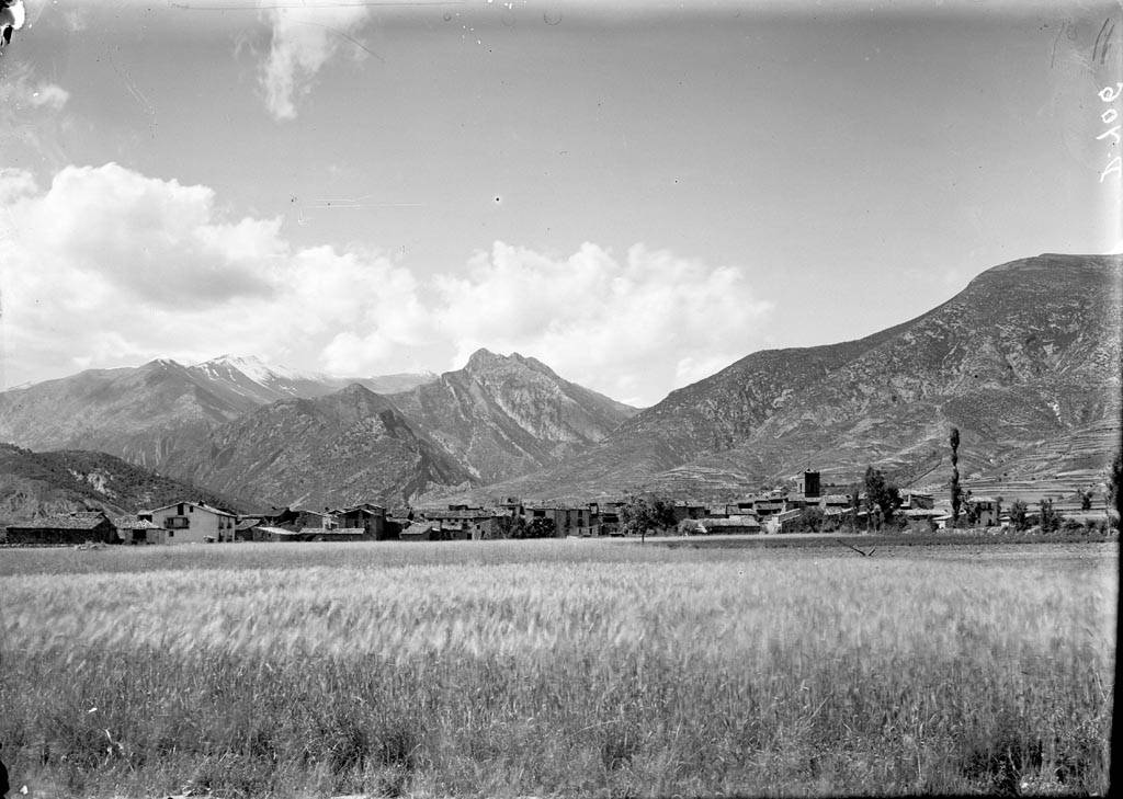
A village above the Cinca valley
Tourism in Tella-Sin takes place in a high corner of Sobrarbe, above the Cinca valley and close to the boundary of Ordesa y Monte Perdido National Park. The villages of Tella and Sin sit along a slope facing the major peaks of the central Pyrenees. Tella itself stands at over 1,300 metres. In this setting, the mountains are not just a backdrop. They shape the climate, influence access routes and determine how settlements have developed.
The municipality has just over two hundred residents spread across several small hamlets. Population has always been low and dispersed, a common pattern in this part of the Pyrenees where villages were established near grazing land and usable terrain. That connection to mountain livestock farming still defines the area, even as it now shares space with a quiet form of tourism, most noticeable in summer and on certain weekends.
Tella-Sin offers a clear example of traditional settlement in Sobrarbe. Houses are built from stone, with slab roofs and the distinctive truncated conical chimneys typical of the Aragonese Pyrenees, designed to withstand snow and wind. There have been no major urban transformations. Streets follow the slope and orientation of the land rather than any modern plan.
Stone, terraces and views
The village of Tella can be explored quickly. Its parish church occupies the most visible point and reflects the gradual extensions and alterations seen in many Pyrenean churches over time. The interest lies less in a single monument and more in its position within the village and the continuity of the surrounding buildings.
Around Tella, small Romanesque hermitages are scattered across the mountainside. These modest structures form part of a well-known local route and point to an older pattern of settlement on these slopes. They also help explain how such buildings once marked territory and guided movement between villages.
Further down the hillside, Sin is arranged in terraces above the valley. From its upper streets, there are wide views to the north. On clear days, the skyline is dominated by the peaks of the Monte Perdido massif. The setting makes clear why villages were established with this orientation: winter sun, a clear line of sight over the valley and some shelter from the wind.
The güells of Tella
One of the most distinctive features of the area is the güells de Tella, a group of sinkholes formed by karst processes. This is not the landscape many associate with the Pyrenees, which are often linked to forests and rocky ridges. Here, the ground drops into large circular depressions that open up clearings within the woodland.
A marked path allows visitors to reach several of these dolines on a relatively short walk. It is not a demanding mountain excursion. Instead, it works as an introduction to the geology of the area and to the traditional uses of these spaces, some of which have been used as pasture.
Walking from Tella-Sin
Tella-Sin is often used as a base for walking in the upper Sobrarbe. Paths begin in the villages and lead across nearby hills or connect with longer routes heading towards mountain passes and neighbouring valleys.
Options range from short local walks, including the hermitage route or the güells circuit, to more demanding itineraries with significant elevation gain. The Pyrenean terrain becomes apparent quite quickly. Slopes are long, weather conditions can change suddenly and paths may remain covered in snow for much of the winter.
The proximity of Ordesa y Monte Perdido National Park expands the possibilities for those who want to explore further, as do the valleys that open towards Bielsa.
Wildlife is part of the experience here. The bearded vulture, known locally as quebrantahuesos, can sometimes be seen gliding above the slopes when observed patiently, often with binoculars. In higher areas, the sarrio, a Pyrenean chamois, moves across pasture and rocky ground, especially near grazing zones and steeper terrain.
Traditions and seasonal rhythms
Local customs follow the rhythm of the year. Patron saint festivals are usually held in summer, when many former residents return to the village. In winter, the celebration of San Antón continues, with the blessing of animals and bonfires in the village. This tradition is widespread across the Pyrenees.
The rural calendar remains visible in livestock practices. Herds are taken up to high pastures during the warmer months and brought back down when the cold sets in. Although livestock farming no longer carries the same economic weight as it once did, it still forms part of the human landscape of the valley.
Reaching Tella-Sin
The usual approach is from Aínsa, following the road along the Cinca valley towards Bielsa. Before reaching Bielsa, a signposted turn leads up to Tella and Sin along a mountain road with numerous bends.
In winter, it is advisable to check road conditions if there is snow, which is relatively common at this altitude.