Full Article
about San Tirso de Abres
Exemplary Village Award
Hide article Read full article
A valley drawn by water
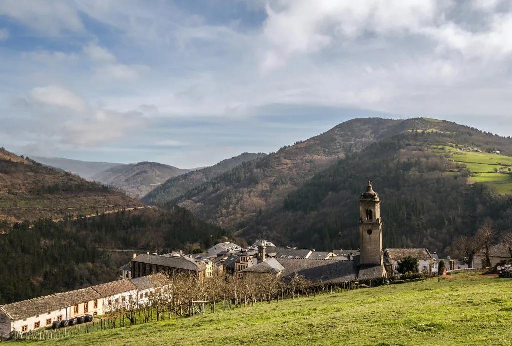
San Tirso de Abres makes sense only when you look at the river first. The River Eo widens here, right on the border between Asturias and Galicia, creating a floor of small hay meadows between wooded slopes. The valley opens out just enough to farm, but not enough to urbanise. That balance has shaped everything.
This is western Asturias, where settlement followed livestock and kitchen gardens rather than grand plans. The population is scattered across small hamlets instead of gathered into a single, tidy centre. On a map the distances appear short. On the ground, houses sit in clusters separated by fields, tracks and streams, each group responding to the lie of the land and the nearest reliable water source.
It feels rural in a practical, working sense. Meadows are fenced. Tracks are narrow. Tractors still use the same lanes that visitors now follow at cautious speed.
A village without a village square
Anyone arriving in search of a compact old town may need to reset expectations. San Tirso de Abres does not revolve around a central plaza lined with cafés. It functions as a collection of small nuclei such as Piñeira, Paramios and Barbeitos, each shaped more by terrain than by symmetry.
Traditional rural architecture survives in these hamlets. Stone walls anchor houses to the ground. Wooden galleries face south to catch the light. Hórreos and paneras, those raised granaries so characteristic of Asturias, stand close to the homes they once supplied. Their presence is not decorative. They speak of storage, harvest cycles and self-sufficiency.
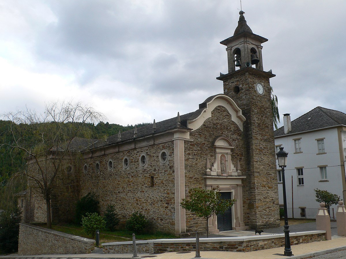
The parish church of San Tirso stands in what now acts as the administrative centre. The present building is generally associated with the 16th century, though later alterations changed parts of its appearance. It is not monumental, and that is part of its story. For centuries, in a valley where people lived dispersed across hillsides and meadows, this church provided one of the few fixed meeting points. Its importance lay less in scale than in function.
From the church surroundings the relationship between settlement and river becomes clear. The Eo dictates the rhythm of the territory. Near the water, old mills, washing places and fountains can still be identified. Many sit beside paths or at the edge of hamlets, reminders that daily life once depended directly on small watercourses as much as on the main river itself.
Paths through a damp, wooded landscape
San Tirso de Abres belongs to an inland Atlantic landscape. Moisture is a constant presence. Chestnut and oak cover much of the slopes, while riverside vegetation thickens along the banks. In autumn the hills change colour and the ground turns soft underfoot, layered with leaves and damp earth.
Mushrooms appear at this time of year, although collecting them is usually subject to local rules. It is sensible to check before entering communal or private land. The valley is not an open park; it remains a lived-in, worked landscape.
One of the best ways to read that landscape is along the route of the old railway line that once crossed the valley. Several stretches now serve as a path for walking or cycling. The gentle gradient of the former tracks allows for an unhurried view of the surroundings. River, transport corridor and hamlets align in ways that reveal how communication routes and natural features have organised the territory over time.
Elsewhere, traditional paths link the hamlets. These are practical routes rather than curated attractions. Good footwear is advisable. Surfaces can be uneven, and Atlantic drizzle has a habit of settling in for days, even outside winter.
Practicalities in a dispersed place
Because San Tirso de Abres is spread out, visiting requires a different mindset from that used in more compact Asturian towns. The interest lies in moving through the valley and noticing detail: the orientation of a wooden gallery, the position of a hórreo beside a vegetable patch, a narrow stream cutting across pasture.
Driving between hamlets is often the simplest approach. Roads are local and sometimes narrow, and parking calls for care. Access tracks double as working routes for residents and farm vehicles. Blocking a gateway or field entrance is more than inconvenient here; it disrupts daily routines.
Public transport exists but is limited, and a car makes it easier to explore at a relaxed pace. Mobile coverage can fail in parts of the valley. Offline maps or a GPS device are useful if planning to follow minor tracks or rural paths.
Time behaves differently in a place organised around agriculture and dispersed settlement. There is no obvious “high street” moment. Instead, a visit might consist of an hour wandering through a riverside hamlet, another spent along the old railway path, and a pause near one of the fountains that once supplied an entire cluster of houses.
When to go, and what to expect
Spring and autumn suit the valley particularly well. In spring the meadows brighten and the woods regain depth after winter. Autumn brings colour to chestnut and oak, and a heightened sense of the valley’s damp, fertile character. Both seasons avoid the extremes of summer heat and winter rain, although weather here is never entirely predictable.
Rain is part of the identity of this inland Atlantic corner. It feeds the river, sustains the vegetation and shapes the building materials. Stone and wood make sense in a climate where moisture lingers. Visitors should pack accordingly.
San Tirso de Abres does not present itself as a checklist of sights. It asks for slower observation. The absence of a compact centre can feel disorientating at first. Yet that same absence explains the place. Settlement followed fields and water rather than an abstract plan, and the result remains visible.
Spend a little time near the Eo, notice the spacing between houses, trace the line of the old railway. The valley reveals itself gradually, in fragments. That is its logic, and its appeal.