Full Article
about Pájara
Municipality with the longest coastline in Spain; home to the vast beaches of Jandía and Sotavento; windsurfing paradise
Hide article Read full article
A southern stretch shaped by wind
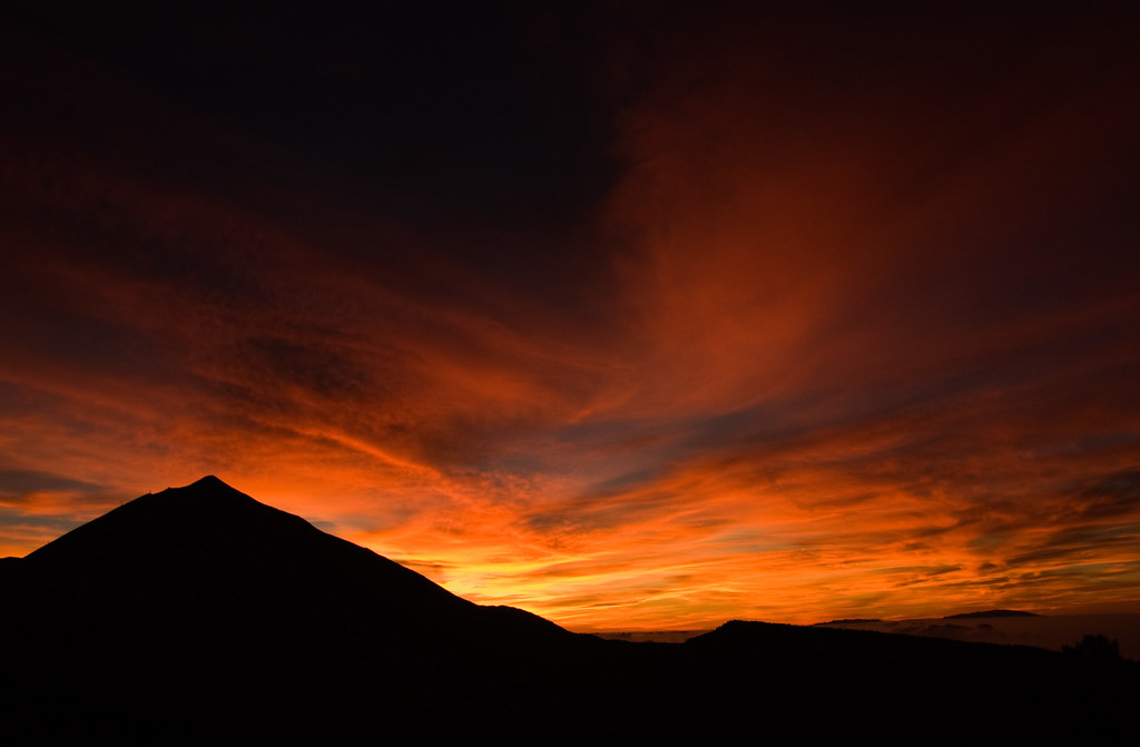
At 807 metres, the pico de la Zarza is the highest point on Fuerteventura. From its summit, the scale of Pájara becomes clear: a vast sweep across the island’s south where ravines run down towards the Atlantic and the coastline stretches for dozens of kilometres with barely a break. Wind is not an occasional presence here, it is part of the setting, as constant as sand or volcanic rock.
Most of the municipality lies within the peninsula of Jandía, an area that remained historically cut off from the rest of the island. Its rugged terrain and the lack of proper routes meant that connections only improved well into the 20th century. Even now, that sense of distance lingers, shaping how the landscape is experienced.
A peninsula once set apart
For centuries, the Jandía peninsula functioned as a separate seigneurial territory within Fuerteventura. Control of the land was tied to feudal-style concessions from the early modern period, when its resources held economic value. Livestock and certain coastal products formed the basis of that interest.
One of the most recognisable figures linked to this more recent history is Gustav Winter, a German engineer who settled in Jandía during the first half of the 20th century. In the 1930s he commissioned the construction of the villa of Cofete, an isolated house set in an almost empty landscape. Over time, many stories have circulated about his role during the Second World War. What is documented is his involvement in agricultural and livestock projects across the peninsula.
Long before that, the village of Pájara had already taken shape inland as a small settlement. At its centre stands the church of Nuestra Señora de Regla, built in the 17th century and expanded in the 18th. It remains the most distinctive building in the historic centre. Its façade stands out for decoration that is unusual in the Canary Islands, with reliefs that some scholars have linked to influences from the Americas. There is no full agreement on their meaning, but it is the kind of place that invites a pause to take in the details.
The village itself keeps a quiet scale. Low houses and short streets cluster around the square, maintaining a rhythm that feels far removed from the coast.
Coastlines that shift with the wind
The coastline of Pájara changes character depending on where you stand. To the east, between Costa Calma and Morro Jable, beaches are long and open, with pale sand and steady wind. That same wind is what turned this stretch of the island into a well-known setting for windsurfing and kitesurfing decades ago.
On the western side, beyond the ridge of Jandía, the landscape becomes harsher. Cofete and Barlovento are vast beaches facing directly onto the Atlantic, where the sea often arrives with force. These are not places designed for long swims. They are better suited to walking and taking in the scale of the territory: kilometres of sand with very little built around them.
The interior of the peninsula also rewards time and attention. The ascent to pico de la Zarza is the best-known walk in the area. The path begins near Morro Jable and climbs gradually to the summit. It is not a technical route, but it is long and very exposed to the sun. On clear days, the view from the top opens out across the western side of Jandía, with the beach of Cofete stretching out in the distance.
From goat herds to the table
Local cooking in Pájara remains closely tied to the land. Queso majorero, made from the milk of the island’s native goat breed, is one of the most recognisable products of Fuerteventura and is easy to find across the municipality.
Traditional kitchens also feature jareas, fish that has been split open and air-dried, a method of preservation with deep roots in the eastern Canary Islands. Cabrito, simple stews and gofio, a toasted grain flour typical of the Canaries, still appear on many tables.
In the more tourist-focused areas, the range of food is broader. In the village of Pájara, however, that direct connection to local produce is still noticeable.
Getting around this wide landscape
Pájara is one of the largest municipalities in the Canary Islands, and distances can be deceptive on a map. The village of Pájara lies inland, while Morro Jable and Costa Calma concentrate most of the accommodation along the coast.
Exploring Jandía is easiest by car. The track leading down to Cofete remains long and partly unpaved, and the journey can take considerably more time than it first appears.
Services are scarce on the beaches along the western side. Anyone heading there usually brings water and some food. The sea is often strong and currents can shift quickly, so caution is part of the experience.
For those interested in walking, several marked trails cross the peninsula. In summer, starting early makes a difference, as the sun is intense and shade is limited for most of the route.
Pájara is not defined by a collection of monuments so much as by its scale. Wind, distance and a lingering sense of isolation continue to shape this corner of Fuerteventura. Here, the landscape sets the terms.