Full Article
about La Orotava
Historic town with one of the most beautiful old quarters; covers much of Teide National Park; famous for its carpets.
Hide article Read full article
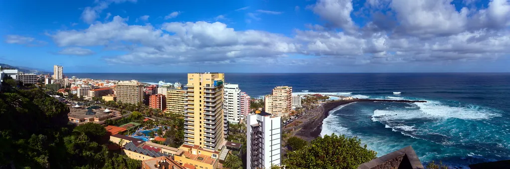
A valley between Teide and the Atlantic
Tourism in La Orotava begins with the valley itself. Between Mount Teide and the Atlantic opens a broad volcanic basin where the land steps down in natural terraces towards the sea. Ancient lava left fertile soils and a slope that catches the sun well. When Castilian forces took the island in the late 15th century, they quickly understood the agricultural value of the area. Land was divided, vineyards appeared, and the valley began to organise itself around this productive landscape that is still easy to recognise today.
That structure remains visible in how the town relates to its surroundings. The historic centre sits above, while the cultivated land stretches below, descending gradually towards the coast. It is not a place separated from its farmland but one that grew directly out of it.
When La Orotava held economic weight
During the early modern period, La Orotava was one of Tenerife’s economic centres. From here, many of the valley’s estates were managed, and the nearby port, now known as Puerto de la Cruz, served as the exit point for wine exported to England and other European markets.
For a time, the town sought a stronger political role on the island. That ambition was affected by volcanic episodes in the early 18th century, which damaged this part of Tenerife and led to long periods of rebuilding in the town centre. The current Iglesia de la Concepción, constructed in the 18th century on the site of an earlier church, belongs to that phase of reform and consolidation that shaped the town as it appears today.
What remains from that period of prosperity is most visible in domestic architecture. The grand houses of the historic centre follow a consistent pattern: interior courtyards, wooden galleries, and large balconies made from Canary Island pine. These elements were not purely decorative. From these balconies, agricultural products could be aired, the valley’s estates observed, and a form of social life maintained without leaving the house. Some 17th-century homes still preserve this structure almost intact, offering a clear sense of how daily life was organised.
A square transformed by volcanic sand
Each year, during the feast of Corpus Christi, the Plaza del Ayuntamiento changes completely for a few hours. Residents and local groups create carpets using volcanic sands brought from the surroundings of Mount Teide, sorted by their natural colours. Work begins at dawn, and the result lasts only as long as it takes for the procession to pass.
The tradition is more than a century old and has become one of the most recognisable images of La Orotava. Its most striking feature is its temporary nature. The designs are destroyed on the very day they are completed.
Shortly afterwards comes the romería of San Isidro, a rural pilgrimage that shifts attention back to the agricultural life of the valley. Decorated carts, livestock and groups dressed in traditional clothing move along the routes that connect the town centre with cultivated areas. Rather than a tightly organised parade, it feels like a celebration spread across the municipality, tied closely to the land that sustains it.
Humboldt’s view of the valley
In 1799, the naturalist Alexander von Humboldt passed through La Orotava during his scientific journey to the Americas. From a high point in the valley, now known as the Mirador de Humboldt, he drew one of the most recognised profiles of Mount Teide, with the valley opening out towards the sea.
That perspective helps explain the landscape’s variety. Within a short distance, the terrain shifts from subtropical crops to areas of chestnut trees and pine forest. Some of the municipality’s walking routes follow paths similar to those used by travellers and naturalists of that time, descending from viewpoints over the valley down into the historic centre.
Another route traces the remains of old hydraulic mills that once used the ravines to power machinery. Many stopped operating decades ago, but the stone structures and the channels that carried water to the wheels can still be identified. They form part of a quieter layer of the landscape, where industry and geography once worked closely together.
Cooking shaped by the land
Local cooking in La Orotava is closely tied to what is grown in the surrounding valley. The mojo prepared here tends to be more aromatic than spicy, made with cumin, oregano from the valley and sweet paprika, all ground together in a mortar.
Papas arrugadas, the small salted potatoes typical of the Canary Islands, are often served with older varieties of papa negra grown in small plots in the midlands. Rabbit in salmorejo also appears frequently, with wine from the valley forming part of the marinade.
Among traditional desserts is bienmesabe, made from ground almonds and palm honey. In many homes it is still prepared in a homemade way and served in small portions. It is a dense dessert, intended to be eaten slowly.
A garden built for a mausoleum
In the Jardines Victoria stands one of the more unusual structures in La Orotava: the mausoleum of the Marqués de la Quinta Roja. It was commissioned at the beginning of the 20th century by the marquis’s widow, although he was never ultimately buried there. The result is a monumental structure surrounded by terraced gardens that look directly over the valley.
Today, the space serves a far more everyday purpose. Residents come here to walk or sit for a while on the benches. From this elevated point, the organisation of La Orotava becomes clear: the historic centre in the upper part, and below it, the valley descending steadily towards the sea.