Full Article
about Bárcena de Cicero
Between marshes and beaches
Hide article Read full article
Crossing the Santoña estuary
The Puente de Treto, which spans the Santoña estuary, says a great deal about where Bárcena de Cicero sits on the map of Cantabria. For a long time, this was one of the key crossing points for anyone heading towards the Basque Country. Before the bridge existed in its current form, getting across the estuary meant relying on slower systems.
The structure seen today dates from the late 19th century, a period when transport and communications were beginning to modernise. Its purpose was practical rather than aesthetic. It made it possible to cross the estuary directly instead of taking a long inland detour. Traffic still flows across it today, though every so often a car pauses, drawn by the view over the water and the surrounding marshland.
A village set back from the sea
Bárcena de Cicero is not a coastal village in the strict sense. The main settlement lies a few kilometres inland, positioned on a slope overlooking the estuary. This location reflects its past. The area developed around agriculture and its connections with nearby ports, especially Santoña.
The layout of the village follows that rural logic. Streets are oriented to make the most of sunlight, and traditional houses combine living spaces with working areas. Many still feature stone walls and south-facing balconies. These balconies were useful for drying crops and making use of natural light, a practical detail that shaped daily life.
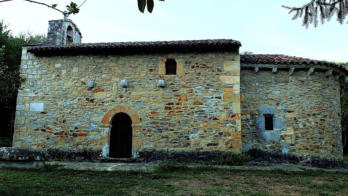
At the centre stands the church of San Pedro. Its origins go back to the 16th century, although it has been altered over time. It is not an imposing monument, yet it helps explain how the village was organised. The parish once structured the rhythm of local life, and the square around it continues to function as a meeting point.
Between marshland and low hills
The municipality stretches from the edges of the Santoña marshes up to the first low rises of the Cicero hills. This transition between wetland and higher ground has long influenced how the land is used. Meadows support livestock, small plots serve agriculture, and paths connect the area with nearby ports.
The Puente de Treto strengthened these connections. It made it easier to move goods from inland areas and reinforced routes towards eastern Cantabria and the border with Bizkaia. Many of today’s roads follow paths that were already in use centuries ago.
Bárcena de Cicero is not a single settlement but a group of localities, including Gama and Cicero. These places still retain a strong link to the countryside. Traditional farmhouses are easy to spot. They typically have a ground floor used for animals or tools, living quarters above, and wide doorways designed to allow carts to pass through.
Life with the estuary in view
Even without direct access to the coast, the Santoña estuary is a constant presence. From higher points within the მუნიციპალity, views open out over the marshes. On clear days, the hills on the Basque side can be seen in the distance.
The proximity to water also shapes the climate. Winters tend to be mild, and humidity is common in summer, conditions typical of this stretch of the Cantabrian coast.
Historical records reveal another side of local life. Parish archives mention trades linked to the maritime world, such as shipwrights and caulkers who worked in nearby ports. This was an indirect relationship with the sea. Many residents remained tied to agriculture while also finding work in shipyards or port activities around the estuary.
Finding your bearings
Bárcena de Cicero lies alongside the A‑8 motorway, on the route between Santander and the eastern coast of Cantabria. The most common approach is via the Puente de Treto. From there, a local road climbs towards the main settlement.
The village itself can be explored at a relaxed pace without needing much time. The square of San Pedro provides a natural starting point, with streets branching out and rising gently along the slope. From certain spots, the view opens across the valley and towards the marshland.
Those interested in rural architecture will notice details that speak to the area’s past. Wide entranceways on older houses hint at their agricultural use, while some façades still display long wooden balconies. To extend the route, the road leading up towards Cicero offers a clearer sense of the municipality’s terrain and its visual relationship with the Santoña estuary.