Full Article
about Covaleda
Heart of the Pinares region, set among mountains where the Duero is born.
Hide article Read full article
A Village Shaped by the Forest
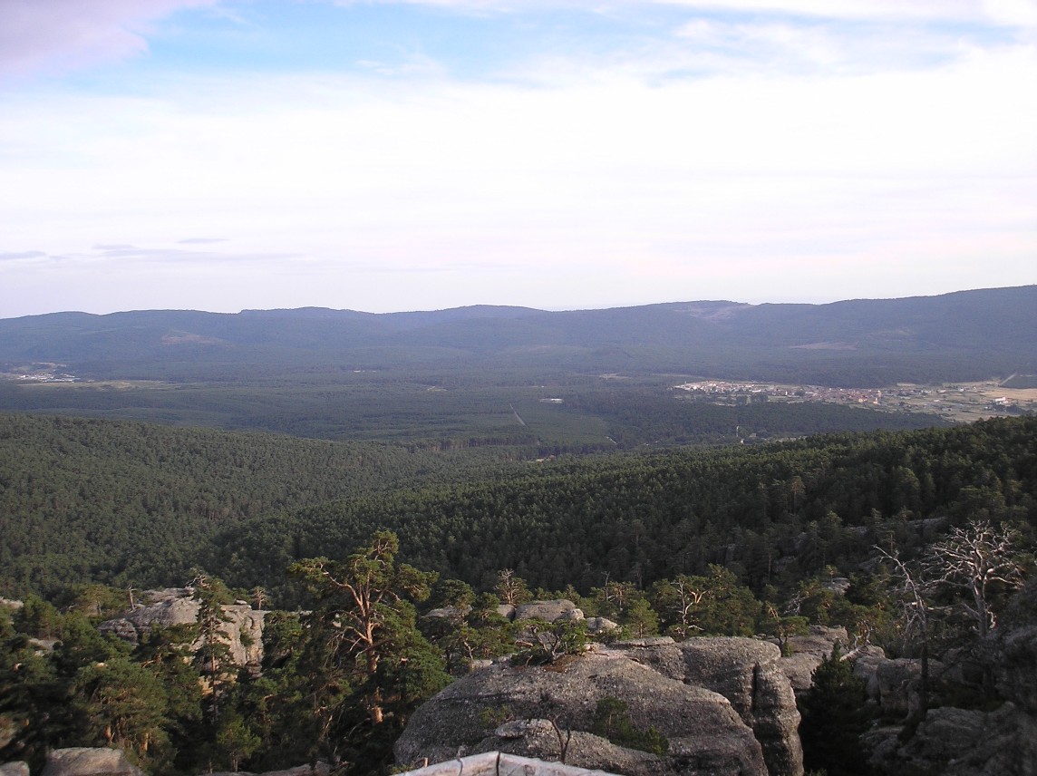
Tourism in Covaleda revolves around one very specific element: the pine forest. The village lies at the northern edge of the province of Soria, in the comarca of Pinares, at around 1,200 metres above sea level on the Soria side of the Sierra de Urbión. Here, the landscape is not a recent backdrop for visitors but the foundation of local life for centuries.
The communal mountain land, traditionally managed by the village itself, has long set the pace of work and shaped the local economy. Timber, resin and forest-related trades defined everyday routines and sustained generations. That close link with the monte still explains the layout of the village and its surroundings.
Covaleda is one of the more populated settlements in the area and retains a direct relationship with the forest that encircles it. A short walk from the centre is enough to enter a continuous stretch of pinewoods that climb towards the summits of Urbión. The sense of transition is immediate: houses give way to tall trunks and sandy tracks within minutes.
Laguna Negra and the Landscape of Urbión
The best-known site in the municipality is the Laguna Negra, set high in the sierra. This glacial lake sits enclosed by rocky walls, surrounded by Scots pine and bare rock that give it the dark, austere appearance reflected in its name.
The setting became widely known through Antonio Machado’s poem La tierra de Alvargonzález, which is set in these mountains. For Spanish readers, Machado is a central literary figure of the early 20th century, and since the poem’s publication the lagoon has been closely associated with his severe vision of the Sorian landscape.
The usual access is via the road that climbs from Covaleda and Vinuesa. Near the top, it is often necessary to leave the car in a designated car park and continue on foot along a clearly marked path. The walk to the water’s edge takes around half an hour, with a gentle incline. On busy days the quiet character of the place changes noticeably, yet the dominant presence remains rock and forest.
Above the lagoon, the terrain continues to rise towards the higher ground of the Sierra de Urbión, reinforcing the sense that this is a landscape defined by altitude and stone rather than by large settlements or cultivated land.
The Village and the Church of San Quirico and Santa Julita
Covaleda’s urban centre is practical in character, typical of a mountain village whose livelihood depended on forestry. There are no major monumental ensembles, though traditional stone houses survive, some incorporating timber in balconies and galleries. Their design reflects the need to withstand long winters at this altitude.
At the heart of the village stands the parish church of San Quirico y Santa Julita. The building has gone through several construction phases. Remains from earlier periods, probably medieval, coexist with later extensions that continued into the modern era. The interior is restrained, as is common in many parish churches in this part of Soria. The bell tower remains a clear landmark within the village layout, visible from different streets and acting as a reference point in an otherwise modest skyline.
The overall impression is of a working settlement rather than a preserved historic showpiece. Covaleda’s identity is tied less to grand architecture and more to its enduring connection with the surrounding forest.
Forest Tracks and Mountain Routes
Beyond the built-up area, the defining feature of the territory is the pine forest of the comarca de Pinares, with the Sierra de Urbión rising behind it. From Covaleda, forest tracks and footpaths lead towards neighbouring villages and up into the higher reaches of the sierra.
Some of these routes follow old working and communication paths once used to move between settlements before modern roads existed. Today they are used for walking or cycling and offer a practical way to understand how people once travelled through this terrain.
Among the mountain routes, the ascent to Pico Urbión stands out. At 2,228 metres, it is not a short outing and requires preparation. Weather conditions can change quickly at this height, and much of the route crosses high mountain ground. On clear days, the summit provides wide views across the Sistema Ibérico and the vast pinewoods covering the Sorian slopes below.
The forest tracks are also popular for mountain biking. They are generally long, with moderate gradients along many stretches, and pass through areas where the only constant sound is the wind moving through the pines. The experience is less about technical difficulty and more about distance and immersion in woodland.
Seasons in the Pinewoods and Nearby Excursions
The character of the monte changes markedly with the seasons. In autumn it is common to see people searching for níscalos, boletus and other mushroom species in the pinewoods. Mushroom picking is regulated across much of the comarca, so it is advisable to check the current rules before heading out.
Winter brings frequent snow to the higher parts of Urbión. When conditions allow, some tracks are used for snowshoeing or cross-country skiing. This is not a developed ski resort, but rather a natural mountain environment where activities depend entirely on weather and snow cover.
From Covaleda it is also relatively easy to reach other well-known natural sites in the province of Soria. One example is the Fuentona de Muriel de la Fuente, a karst spring where water emerges forcefully from the depths of a cavity. It is not in the same valley nor just a few minutes away, yet many visitors include it as part of a day exploring the wider comarca.
Covaleda sits on the road that crosses the comarca de Pinares between Soria and Burgos, and the village itself can be explored comfortably on foot. For those planning to visit the Laguna Negra, it is worth checking in advance how car access is managed, as traffic on the final stretch of road is regulated at certain times of year. Bringing warm clothing, even in summer, is a sensible precaution. At this altitude, the weather can shift quickly, and the mountains of Urbión set their own pace.