Full Article
about Galende
Municipality home to Lago de Sanabria and its beaches; a top summer tourist spot with spectacular nature and Sanabria-style architecture.
Hide article Read full article
A Municipality Shaped by Water and Mountains
Tourism in Galende revolves, above all, around the Lago de Sanabria. The municipality lies on its eastern shore, within the comarca of Sanabria in the province of Zamora, and forms part of the immediate surroundings of the Parque Natural del Lago de Sanabria. At around 1,000 metres above sea level and with just over a thousand inhabitants spread across several villages, life here has always been shaped by the mountain climate, the presence of the lake and the surrounding uplands.
Galende functions less as a single settlement and more as an administrative area that brings together a network of small villages. Under its authority are some of the best-known places in the area, including Ribadelago, San Martín de Castañeda and Pedrazales. Many visitors arrive focused on the lake and only later realise that these villages, scattered between the shoreline and the nearby slopes, are very much part of the experience.
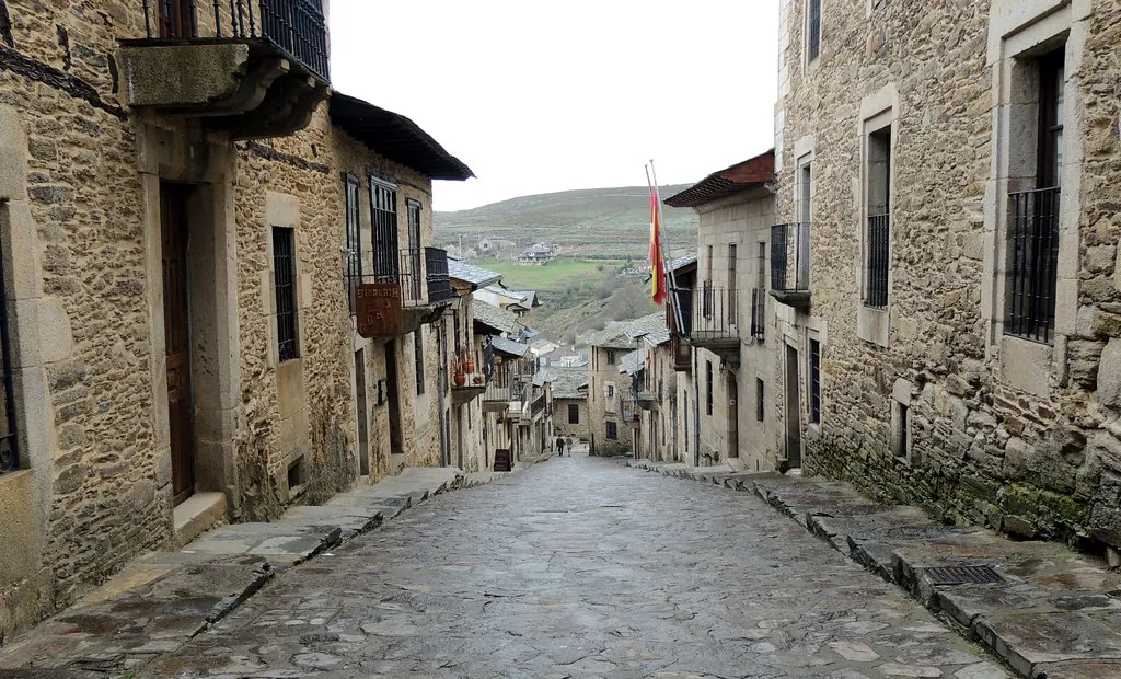
In the village of Galende itself, stone construction dominates. Granite and slate, materials typical of Sanabria, define the look of the houses. The buildings are solid and restrained, designed to withstand long winters. Wooden galleries still appear on some façades, a traditional feature used to dry produce and provide extra protection against the cold. The architecture reflects practical responses to a demanding climate, where snow is not unusual in some years.
Lago de Sanabria and Its Villages
The Lago de Sanabria is the largest glacial lake on the Iberian Peninsula. It covers roughly 300 hectares and exceeds 50 metres in depth at certain points. Its present shape is the result of retreating glaciers that filled this valley during the final phases of the last Ice Age, leaving behind the broad basin that now holds the lake.
The surrounding mountain ranges, particularly the Sierra Segundera, help explain the character of the landscape. Rounded peaks, wide valleys and woodlands dominated by oak, chestnut and birch define the scenery. In autumn, the change in colour across these forests is especially noticeable, transforming the slopes around the water.
Several of the municipality’s most recognisable villages are arranged around the lake. San Martín de Castañeda sits high above the shore, commanding open views from the hillside. Here stands a former Cistercian monastery, whose Romanesque church remains intact. In the Middle Ages, the monastery played an important role in organising the surrounding territory. Today it houses a small interpretative space dedicated to the natural park, offering context for the landscape and its history.
Closer to the water lies Ribadelago, marked by a more recent and tragic episode. In 1959, the Vega de Tera dam burst, unleashing a flood that destroyed the original village. Ribadelago Viejo remains as a reminder of that catastrophe, while the current settlement was rebuilt nearby in the aftermath. The memory of the disaster forms part of the area’s contemporary history and identity.
Pedrazales, for its part, is often one of the usual access points to the lake and to several walking routes within the park. From here, visitors set out towards the water or into the surrounding hills, depending on the season and their plans.
Walking Routes and the Sierra Segundera
The Parque Natural del Lago de Sanabria has an extensive network of waymarked paths. One of the best known is the Ruta de los Monjes, which begins in San Martín de Castañeda and follows part of the lakeshore. Depending on the chosen variant, the route covers around eight to ten kilometres. It passes through oak woodland and sections that run close to the water, combining forest and open views.
For those with more mountain experience, the Sierra Segundera draws attention. From this massif rise some of the highest elevations in the area, including Peña Trevinca at 2,127 metres, the highest point in the province of Zamora. These are not outings to be improvised. Distances are considerable and weather conditions in the sierra can change quickly, adding an extra layer of difficulty to longer routes.
During the summer months, activity tends to concentrate around the lake itself. There are designated bathing areas along several stretches of shore, and the water remains cold even on the hottest days. Canoes and small non-motorised boats are a common sight. In August, access points can become crowded, something worth bearing in mind when planning a visit at that time of year.
Practical Notes and Traditional Architecture
Moving around the municipality of Galende generally involves travelling by car from one village to another. Distances are short, yet some stretches of road are narrow. The landscape dictates the layout: winding routes that adapt to the contours of the hills and the edge of the lake.
Anyone interested in traditional Sanabresa architecture will find clear examples throughout the municipality. Look for very thick stone walls, heavy slate roofs and wooden galleries usually oriented to the south. Each of these elements answers directly to the local climate, with cold winters and, in some years, significant snowfall. The buildings are not decorative statements but practical structures shaped by necessity.
Galende and its villages are closely tied to their natural setting. The lake, the forests and the sierra are not backdrops but defining features. Visitors may arrive for the Lago de Sanabria, drawn by its glacial origins and mountain setting, yet the wider municipality reveals a landscape where geography, history and settlement remain closely intertwined.