Full Article
about Villar del Río
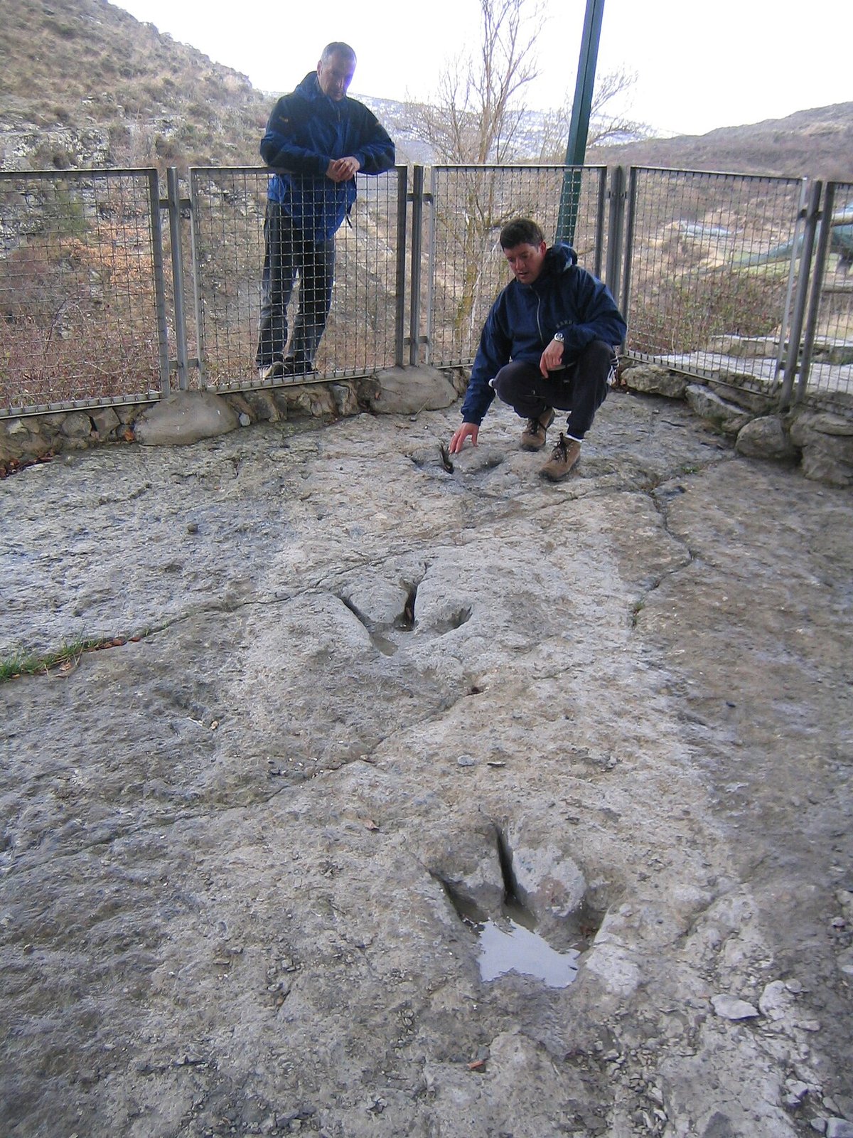
Hub of the dinosaur-track route, with a paleontology classroom
Hide article Read full article
Villar del Río lies at the northern edge of the province of Soria, within the region known as Tierras Altas, one of the most sparsely populated areas in Castilla y León. The village stands at around 1,050 metres above sea level, in a landscape of open high plains, long winters and very small settlements scattered between low hills and juniper trees. Today, around 155 people live here.
The layout of the village still reflects the practical logic with which these communities were built. Stone houses cluster together, animal pens are attached to homes, and the narrow streets feel designed for livestock rather than cars. The sense of continuity is strong. Even with a small population, the structure of daily life remains visible in the fabric of the place.
The name Villar del Río became widely known through cinema, though in an unexpected way. In Bienvenido, Mr. Marshall (1953), director Luis García Berlanga gave the fictional village in his film this name. The filming did not take place here. Even so, the association endured, and the real municipality has maintained that link with one of the best-known titles in Spanish film history. For visitors unfamiliar with Spanish cinema, Bienvenido, Mr. Marshall is a classic satire about a rural village preparing for the arrival of American aid in the 1950s. The shared name is a cultural curiosity that still draws attention to this quiet corner of Soria.
San Pedro and the Shape of the Village
The parish church of San Pedro is the village’s principal building. Its origins appear to be medieval, although its current appearance reflects later alterations. Such changes are common in rural churches that were adapted and reworked over centuries as needs and resources shifted. The tower is solid and unadorned, visible from the roads leading into the village and still acting as a clear landmark in the landscape.
Much of the settlement is arranged around the church. Large wooden gates remain on many houses, once allowing access to pens or stables. They are a reminder that livestock farming has long been central to daily life here. Some façades retain old iron grilles, small balconies and walls built from local stone gathered from the surrounding land.
On the outskirts, several dovecotes and auxiliary buildings can still be seen. Not all are in good condition. Even so, they help explain how the village functioned when its population was larger. These structures formed part of the domestic economy, closely tied to farming and animal husbandry.
Walking through the streets does not take long, but the details reward attention. The way homes connect to their adjoining spaces, the proportions of the lanes and the materials used in construction all speak of adaptation to climate and terrain.
The Parameras of Tierras Altas
The landscape around Villar del Río is typical of the Sorian high plains, known as parameras. Wide open expanses stretch out from the village, broken by scattered juniper groves and low scrub. The character of the terrain shifts noticeably with the seasons. It may not impress in an obvious or dramatic way, yet it is strongly representative of this part of Soria.
Agricultural tracks leave directly from the village and make it possible to walk into the surrounding countryside without much difficulty. These are straightforward routes linking fields, low rises and patches of woodland. Distances on these plateaus can be deceptive. What appears close at first glance often turns out to be farther away than expected.
Birdlife is part of the experience. Birds of prey are frequently seen taking advantage of air currents over the open plains. Partridges and hares are common sights, and in quieter areas it is possible to glimpse a roe deer. The environment feels exposed and expansive, shaped by altitude and weather.
The climate has always played a decisive role in life here. Long winters and the demands of working the land have marked the rhythm of the community for generations. The physical setting and the settlement pattern are closely connected.
Exploring Tierras Altas
Villar del Río is also a useful base for exploring the wider Tierras Altas region. Nearby towns such as Yanguas and San Pedro Manrique retain castles, old churches and urban layouts that recall the historical importance of this area during the Middle Ages. At that time, it controlled livestock routes and roads linking Castilla and Navarra.
Understanding the region comes from moving between several small villages. Each has its own church and central square, and each relates in its own way to the demanding landscape that surrounds it. The distances between settlements, the scale of the buildings and the simplicity of materials all reflect a long history of adapting to altitude and isolation.
The medieval past is still legible in these neighbouring towns. Defensive structures and religious buildings point to periods when control of routes and grazing lands mattered greatly. Even without detailed interpretation, the continuity between landscape and settlement is clear.
A Brief Visit, A Lasting Impression
Villar del Río can be explored at an unhurried pace in a short amount of time. The interest lies less in ticking off sights and more in observing how the village is put together. The arrangement of houses, the attached animal enclosures and the tracks leading out into open country provide clues to how a community in Tierras Altas has functioned for centuries.
Life here has always been shaped by climate and work on the land. That reality is written into the stone walls, the robust church tower of San Pedro and the scattered agricultural buildings beyond the last houses. The name may be familiar from Bienvenido, Mr. Marshall, yet the real Villar del Río tells a quieter story, rooted in altitude, livestock and the broad horizons of northern Soria.