Full Article
about Organyà
Site of the discovery of the Homilies of Organyà (early Catalan text); paragliding hotspot
Hide article Read full article
Morning Light in the Lower Alt Urgell
At first light, when the sun barely reaches the upper rim of the valley, tourism in Organyà begins quietly. The Segre flows below with a constant murmur, and shutters lift one by one in the houses near the centre. The stone façades still hold the chill of the night. Walk slowly through the older streets and the village wakes at its own pace.
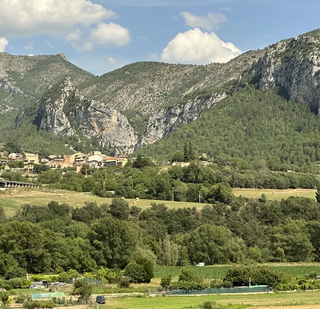
Organyà lies in the lower part of Alt Urgell, in Catalonia, positioned between the flat valley floor and the first slopes that rise towards the north. Just over eight hundred people live here. It is not a place that changes dramatically over time. The mountains set the rhythm of daily life and the river is always present, even when out of sight, sounding a few metres below as a steady backdrop.
The setting explains much about the atmosphere. Peaks close in without overwhelming the houses, and the valley corridor guides both the landscape and the road that runs through it. Everything feels arranged around the course of the Segre.
The Old Centre and Santa María
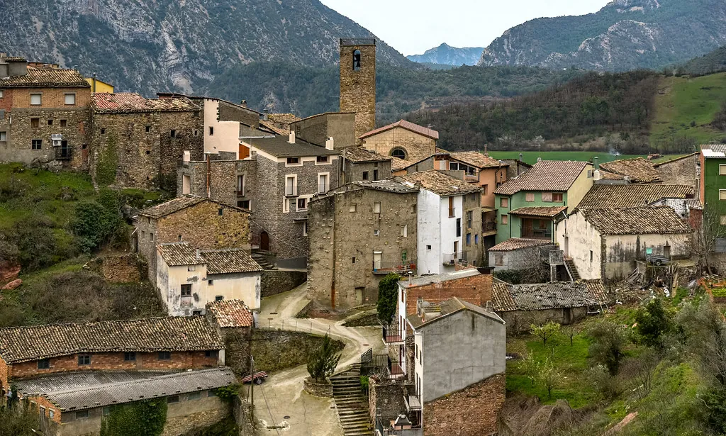
The streets in the historic centre are short and slightly irregular. Many still preserve stretches of stone paving that warm quickly once the sun reaches them. Between the houses stand wide doorways, some framed with old voussoirs, and wrought-iron balconies where pots or freshly washed clothes are often visible.
The church of Santa María defines the village skyline. Its tall, straight bell tower acts as a point of reference when moving through the urban area. The building has Romanesque origins, although later alterations are clear in the shapes and in the height of certain sections. These changes do not hide the earlier structure but add layers that can be read in the masonry.
In the late afternoon, the façade can take on a deep ochre tone. This happens particularly when the light enters from the west and bounces off nearby walls before settling on the stone. It is a simple shift in colour, yet it alters the whole feel of the square around it.
The Segre and the Pont Vell
The Segre runs at the foot of the municipality and changes noticeably with the seasons. After heavy rain it flows dark and forceful. In summer the water is usually clearer, and stretches of gravel bank appear along the edges.
Close to the village stands the so‑called Pont Vell, a stone bridge linked to the historic route through the valley. Over time it has suffered floods and undergone repairs. Before approaching too near the riverbed, it is sensible to check the condition of the area, especially after periods of high water. Even so, from the nearby paths the relationship between the river and the settlement is easy to grasp. The village grew with the Segre at its side, drawing from it while keeping a careful distance from its strongest currents.
From slightly higher ground, the shape of the Segre corridor becomes clear, along with the road that follows it towards La Seu d’Urgell. The valley narrows and widens in turns, guiding movement northwards.
Slopes, Trees and Quiet Paths
Around Organyà, vegetation shifts quickly with altitude. On the lower slopes there are holm oaks and deciduous oaks. Higher up, pines appear along with areas of scrub. When the wind blows, the sound travels through the treetops like a long wave crossing the valley from one side to the other.
Several paths leave the village and head towards old farmhouses and small hermitages scattered across the landscape. These are not usually difficult routes, though it is wise to carry water and to avoid the central hours of the day in summer. Heat lingers in the bottom of the valley for longer than expected.
From certain elevated points, the view opens across the Segre corridor and the road that threads through it. The perspective reveals how closely the built area is tied to its geography. The mountains rise steadily rather than abruptly, and the settlement sits in the space where valley and slope meet.
A Landscape Marked by Fossils
Organyà is known among geology enthusiasts for the presence of marine fossils in particular rock layers. Millions of years ago this part of the Pyrenees lay beneath a shallow sea. Remains of that distant period became trapped in sediments that today form the surrounding mountains.
There are no large facilities in the village devoted to this subject. The interest lies instead in observing the rocks carefully while walking in the area and recognising that this dry, rugged relief was once under water for a very long time. The contrast between the present landscape and its ancient past gives another dimension to the terrain.
Festivities and Everyday Rhythm
Towards the end of summer, Organyà usually celebrates its festa major in honour of Sant Bartomeu. For a few days the pace shifts. Music rehearsals can be heard in the afternoons, people gather in the square until late, and the streets see more movement than usual. It is a temporary change that brings the community together in public spaces.
In winter, around Sant Antoni, bonfires are traditional along with events linked to animals and rural life. When the cold truly sets in, wood smoke hangs low in the valley and mingles with the damp air that drifts from the river. The scent lingers between the houses, blending with the quiet typical of the season.
Outside these moments, daily life returns to its steady rhythm. The population remains small, and the sense of scale rarely shifts.
Getting There and When to Pass Through
Organyà sits beside the C‑14 road, which runs along the entire Segre valley. From Lleida, the route follows this road north, passing several small villages before the valley narrows. From Barcelona, the journey generally approaches the Pre‑Pyrenees through the central area before connecting with the same valley road.
Those seeking a calmer atmosphere may prefer to avoid the busiest summer weekends. On weekdays, particularly early in the morning or towards evening, the village regains its lighter silence. The sound between houses and river becomes clearer again. In those hours, Organyà is easiest to understand: a small settlement shaped by stone, water and the long curve of the valley that holds it in place.