Full Article
about Alforja
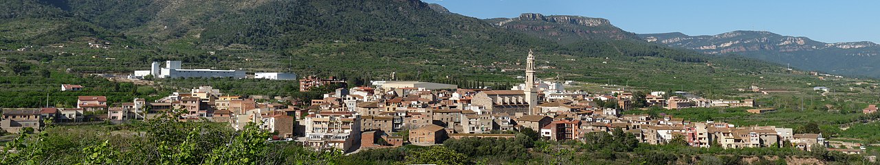
Village set in a valley at the foot of the Sierra de Alforja, a natural route into the Priorat.
Hide article Read full article
A Village Shaped by the Land
Alforja sits at 374 metres on a slope where the sierra de la Mussara meets the agricultural plains of the Baix Camp. The village was not built to be hidden. Its position, halfway up the hillside, provided oversight of the valley, a strategic advantage in earlier times. The streets follow the incline, and from many points in the old centre, your view drops past terraces of olive and hazelnut trees towards the open plain.
The geography is a constant presence. To the north, the wooded ridges of the Mussara; to the south, the cultivated fields that connect Alforja to Reus and the coast. This contrast between mountain and plain defines the place.
After Siurana: A Medieval Layout
Christian control of this area was consolidated in the mid-12th century, after the fall of the Muslim stronghold at Siurana. Alforja’s location on a natural route between the coast and the interior gave it strategic value. The old quarter still follows that medieval logic, with narrow, curving streets adapted to the hillside rather than a planned grid. You can find traces of older construction—a stone arch incorporated into a later house, a covered passageway.
For centuries, daily life has concentrated in Plaça del Mercadal. The streets of the historic core still converge here, as they would have for a market.
At the highest point stands the church of Sant Miquel, built in the 17th century on earlier foundations. The building itself is not large, but its position is everything. From the cleared space around it, the view opens north to the Mussara and, on clear days, south all the way to a sliver of Mediterranean sea. The relationship between the settlement, its church, and the landscape it watched over is clear from here.
Paths into the Mussara and Cortiella Valley
Walkers from across the comarca use the extensive network of trails in Alforja’s municipal area. Marked routes leave directly from the village, following old bridle paths towards hermitages like Sant Antoni and mountain passes in the sierra.
One well-trodden path climbs through terraced farmland and pine forest towards Puigcerver. Others lead to the upper ridges, where the terrain opens views towards Priorat in one direction and the Costa Daurada in the other.
The valley of Cortiella, crossed by the GR‑7 long-distance footpath, carries a local story. It concerns Antoni Mestre, a figure linked to the final Carlist conflicts of the 19th century. Village tradition holds that he was hidden in these mountains by people who knew the paths. Today, the valley is quiet, covered in holm oaks. The tension in that story feels distant from the peaceful scrubland, but the association persists in local memory.
Interior Cooking from the Baix Camp
The cooking here relies on what grows on the surrounding terraces: olive oil, hazelnuts, and vegetables from local plots. One dish is particularly associated with Alforja: pataco. It’s a simple stew of potatoes with tuna and vegetables, still commonly made in homes.
The agricultural cooperative handles the oil and hazelnut production. The nuts are often served toasted, a typical accompaniment to vermut.
In summer, the village holds a fair dedicated to pataco. For a few days, attention focuses on the cooking pots, and families tend to defend their particular recipe. The most common version uses tinned tuna, though some recall older exchanges where fish came from the coast through trade with inland villages, hinting at an older supply network between mountain and shore.
Mercadal Square and Historic Houses
Plaça del Mercadal continues to function as it long has: a convergence point and a natural centre. Market stalls are still set up here periodically.
One side of the square is occupied by the Casa de Cultura, a building that was an 18th-century hospital. The stone arcades on its ground floor are a remnant of that function.
A short walk away is Cal Batlle, a private residence with late medieval origins. Its stone coat of arms and structure are linked to former seigneurial and archbishopric authority in the area. It’s not a museum, but its presence helps explain the centuries-old division between local and ecclesiastical power.
These buildings provide context more than spectacle. They anchor Alforja’s history in specific sites: the square for public life, the adapted hospital, a house that speaks of old hierarchies.
Getting There and Walking Around
The drive from Tarragona typically goes through Reus before taking the road that climbs towards the sierra. There are areas to leave your car at the village entrance.
The historic centre is compact and easily explored on foot. You can reach Sant Miquel church, Plaça del Mercadal, and the trailheads for mountain walks within a short time. To properly walk the routes into the sierra or Cortiella valley, you’ll need to allow for most of a day.
Alforja’s character isn’t announced by grand monuments. It comes from the lay of the land, from stories attached to certain valleys, and from everyday activity—from the terraces below the houses to the tracks that climb into the hills.


