Full Article
about Arenys de Munt
Inland Maresme municipality at the foot of Montnegre and Corredor
Hide article Read full article
A Village Shaped by Its Riera
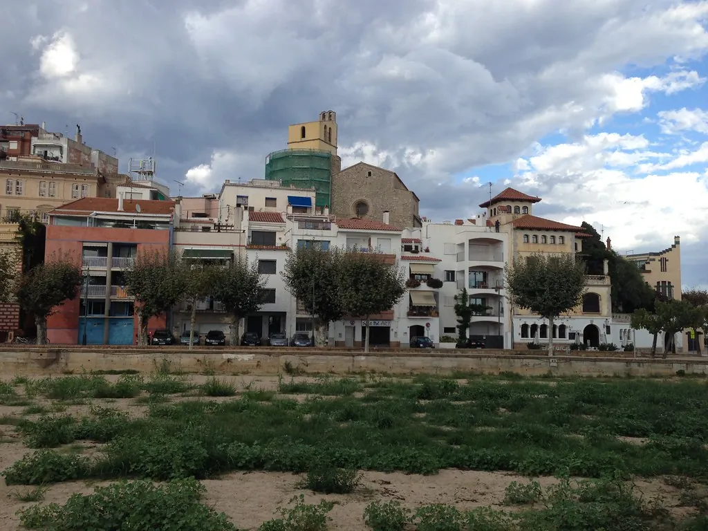
Any look at tourism in Arenys de Munt has to begin with geography. The riera, dry for much of the year and suddenly alive when storms break, runs through the centre and has defined the village for centuries. The medieval settlement took shape around this watercourse in a small basin of the inland Maresme, about three kilometres from Arenys de Mar on the coast.
Here the Cordillera Litoral opens into a valley of heavily eroded granite soils. Pine woods cover the slopes, while the first foothills of the Montnegre draw close from the north. The result is a compact settlement, its houses following the line of the torrent. The layout still makes sense today: the riera acts as a natural spine, with streets branching towards the church and climbing gradually uphill.
The setting explains much about the character of the place. This is not a town built around a grand square or defensive walls, but one that grew in response to terrain and water, adapting to the rhythm of a stream that is absent for long stretches and forceful when the weather turns.
Lace and the Puntaires
In the main square it is not unusual to see puntaires at work with the coixí, the traditional lace-making cushion. This is not a performance for visitors. Bobbin lace has formed part of the local domestic economy since at least the 17th century, when many farming families supplemented income from vineyards and vegetable plots with lace production.
That tradition continues through local associations and workshops where the punto de coixí is taught. This style of lace is firmly associated with the Maresme region. The pieces produced here tend to have fairly dense meshes and simple geometric motifs. Rather than being confined to display cabinets, it remains a craft passed from one generation to the next.
The church of Sant Martí presides over the centre from a slight rise above the riera. The present building was constructed between the 16th and 18th centuries. Architecturally it is sober: a single nave with side chapels and a later altarpiece. Its position, however, helps to explain how Arenys de Munt developed. The first houses clustered around the church and the watercourse, then gradually extended up the slopes where vineyards and cherry trees stood for centuries.
Walking from the riera up towards Sant Martí offers a clear sense of this evolution. The village unfolds in short climbs and narrow streets, with the church marking both a physical and historical centre.
The Cereza d’en Roca
Arenys de Munt maintains a very visible connection with cherry cultivation. The best-known variety in the area is the cereza d’en Roca, linked to a local farmer from the early 20th century, Joan Roca. He is said to have selected and propagated the original tree on his land in the area of Tres Turons.
This variety is distinguished by fruit that is smaller and darker than that produced by intensive farming. Cherry trees can still be found scattered across the sunny slopes of the valley, mixed with pines and old agricultural terraces.
At the beginning of summer the village usually organises a fair dedicated to this cherry. It is largely a local celebration. Stalls fill the square, producers from nearby bring their fruit, and traditional preparations appear in which cherries replace more usual ingredients. The scale is modest and closely tied to the agricultural calendar.
The presence of cherry trees among the pines and abandoned terraces is a reminder of how the valley once functioned. Vineyards, orchards and smallholdings shaped the landscape that now blends cultivation with woodland.
Paths Towards the Montnegre
The edge of the built-up area almost coincides with the entrance to the Montnegre i el Corredor Natural Park. As soon as the last houses fall away, dirt tracks begin to climb the hillsides.
The current landscape combines Aleppo pine woods with Mediterranean scrub. In some shadier areas, particularly towards Tres Turons or Parent Rost, small stands of oak survive, hinting at a more varied forest in the past. Among the pines it is still possible to make out old agricultural terraces once used for growing vines.
One of the most common routes in the surroundings links the hills of Tres Turons. It is a circular walk lasting several hours, without major changes in elevation, passing old masías, traditional Catalan farmhouses, and dry-stone walls. At certain points wild cherry trees appear among abandoned terraces.
The ascent towards Parent Rost is longer. At the summit there is a geodetic vertex and a wide panorama over the inland Maresme. On clear days the Montseny can be seen in the distance. These routes connect the present village with the agricultural and forestry landscapes that have long surrounded it.
Everyday Life and Practicalities
The centre of Arenys de Munt can be explored at an unhurried pace in a short time by following the riera and the streets that lead up towards the church. Daily life is concentrated there: small local shops, the weekly market, and the conversations in the square that still set the rhythm of the village.
From Barcelona it can be reached by car in under an hour, usually via the C‑32 towards the Mataró area and then inland by regional road. Rodalies trains run to Arenys de Mar on the coast, with a road connection onwards to the village.
Summer can be hot in the valley. Late spring and early summer coincide with cherry season, and in September the festa major usually takes place, when the centre fills with community activities.
Arenys de Munt does not revolve around major monuments. Its appeal lies in the balance between traditional agriculture, crafts such as lace-making, and proximity to Barcelona. A walk along the riera, a glance up at the slopes where cherry trees still stand, and the shape of the valley itself explain how this place has sustained its community over centuries.