Full Article
about Albatàrrec
A town near the provincial capital, known for its Renaissance castle and fruit-growing.
Hide article Read full article
A village shaped by the Segre
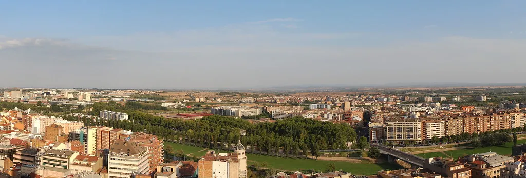
The Arabic origin of the name Abu-l-Táriq, meaning “father of the one who opens the way”, sounds ironic once you realise that Albatarrec has never really been a place of passage. Around six kilometres from Lleida, the river Segre curves into a broad meander and leaves behind a fertile plain. Here, irrigation farming has shaped the landscape for centuries.
Anyone who settled in this spot did so with water close at hand. Historic acequias, traditional irrigation channels, criss-cross the land. The Segre’s irrigation system has long sustained the fields, and in more recent times major works such as the canal d’Urgell and the canal de Seròs reinforced that relationship with the river. Within barely ten square kilometres, everything appears parcelled and organised according to water. Fields fall into neat rectangles, paths trace the lines of channels, and the horizon sits low over the plain of the Segrià.
The village stands on one of the few slightly raised points in the area. From here, the surrounding geography makes immediate sense: the agricultural flatland stretches outward, divided by ditches and tracks, with the Segre always present in the background.
A castle that looks newer than it is
In 1383 the monastery of Bonrepòs purchased the settlement from the Crown. Some decades later jurisdiction returned to royal hands, and over time the domain passed through several owners, among them Antoni Riquer and Francesc d’Espolter. It was during this period that Martí Joan d’Espolter commissioned the construction of the palace-castle in the 16th century.
The building that stands today, built of brick and flanked by cylindrical towers, has a slightly theatrical air. At the beginning of the 20th century it underwent a deliberate medieval-style refurbishment. Battlements and other features were added to evoke a fortress older than it really is. A careful look makes it clear that this is a recreation rather than a preserved medieval stronghold, yet the effect has become part of Albatarrec’s identity.
The church and the castle form the visual heart of the village. From their surroundings, the view extends across the cultivated plain. The landscape does much of the storytelling here, and the architecture sits within it rather than dominating it.
Irrigation as everyday architecture
A walk around Albatarrec follows the logic of irrigation. The acequias run alongside dirt tracks, and small stone bridges connect one plot of land to another. Many farmers still use these traditional crossings to move between fields. The pattern feels practical rather than decorative, built for work and continuity.
The canal d’Urgell cuts across the northern part of the municipal area. This major 19th-century hydraulic project transformed dry farmland in the province of Lleida into irrigated land. In Albatarrec it strengthened a landscape that was already closely tied to water. Along the canal, strips of vegetation have grown up where it is easy to spot common birds of the Segre valley. Paths that follow certain stretches of the canal are often used for walking or cycling from the city.
Close to the urban centre lies an old arm of the Segre known locally as the riu Viu. These smaller secondary watercourses provide refuge for fish and riverside birds. They also add nuance to what might otherwise seem like a strictly agricultural environment. Water here is infrastructure, but it is also habitat.
The orchard and the table
Life in Albatarrec remains closely linked to the agricultural calendar. In spring and summer the orchards of the vega dominate the scene. Peach trees, pear trees and almond trees line the irrigated plots, alongside fields of alfalfa and maize. The cycles of planting, watering and harvesting continue to set the rhythm of the year.
When the spring rains arrive, the village often celebrates a caragolada popular, a communal snail feast typical of the Segrià region. Large quantities of snails are cooked in generous containers with garlic, tomato, aromatic herbs and local olive oil. For readers unfamiliar with the custom, it is a long-standing rural tradition in this part of Catalonia, bringing neighbours together around a simple, robust dish.
Beyond these festive occasions, everyday cooking reflects the market garden. Seasonal vegetables, arbequina olive oil and farmyard produce shape a cuisine grounded in what the land provides. The emphasis remains on ingredients grown or raised nearby, tied closely to the irrigated fields that define the municipality.
A short circuit through the village
Albatarrec does not require long to explore. The principal landmark is the church of Sant Miquel, remodelled in the 18th century. Inside, a Baroque altarpiece is preserved. Local tradition also holds that a Gothic carving, predating the current building and belonging to the medieval church, survives within.
Nearby stands the palace-castle, its brick surfaces and added battlements clearly visible. The scale of the historic centre is modest, and the distance between its main points is short. A brief walk links church, castle and the edge of the cultivated land.
A little further from the built-up area, the riu Viu offers a contrast to the orderly grid of fields. As an old branch of the Segre, it functions as a quieter space where wildlife gathers. These marginal spaces, half agricultural and half natural, are part of the wider story of water in Albatarrec.
Setting and access
Albatarrec lies very close to Lleida, connected by the road that heads down towards Seròs. The journey is short and passes through one of the most characteristic irrigated areas of the Segrià. The approach itself introduces the defining features of the place: flat terrain, rectangular plots and irrigation channels tracing precise lines across the land.
The village can be explored easily on foot. Rather than a series of isolated monuments, Albatarrec is defined by the agricultural landscape that surrounds it. Acequias, field paths and the constant presence of the Segre in the distance give the area its coherence.
At sunset, when irrigation gates are closed and the sound of running water subsides, the plain falls quiet. In that stillness, the organising force of the river becomes clear. Generations have structured their work, their meals and their celebrations around the water that flows through this corner of Catalonia. Albatarrec may not be a place people pass through on the way elsewhere, but its relationship with the Segre has given it a steady and enduring character.