Full Article
about La Coma i la Pedra
Alpine municipality where the Cardener river rises; ski resort and green landscapes
Hide article Read full article
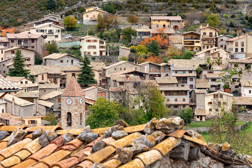
A Municipality of Meadows and Stone
La Coma i la Pedra is a mountain territory, not a village. To understand it, you must first look at a map. The municipality occupies the upper Solsonès, where the land begins to fold into the Pre-Pyrenees. It sits above a thousand metres, under the long ridge of Port del Comte. The name itself is a clue: "La Coma" refers to a high valley basin, "La Pedra" to stone. This is a place of scattered farmhouses, small hamlets, and open pastures threaded between forests of pine.
Fewer than three hundred people live across its entire expanse. This dispersion is historical; settlement here was dictated by livestock, forestry, and the management of water from the mountains, not by the need for a central plaza. The two main nuclei, La Coma and La Pedra, are reference points in a wider geography that includes springs, isolated chapels, and meadows still used for grazing.
A Dispersed Heritage
You will not find a concentrated historic centre. The older architecture is spread across the territory, and to see it requires moving from one point to another.
In La Pedra, the church of Sant Andreu has Romanesque foundations, though its current stone structure shows modifications from later centuries. Its simplicity is typical of these high valleys. It feels anchored to the group of houses beside it and the pastureland around it, not placed for show.
La Coma holds the parish church of Sant Cristòfol, which served a wider pastoral district. Further out, chapels like Sant Bartomeu or Sant Miquel appear alone along paths or on small rises. They were built as stops for farmers and herders moving between valleys, not as destinations. Together, these buildings form a network that maps the old ways of life across this difficult terrain.
Pine Forest and Mountain Paths
The landscape is defined by its forests. Scots pine gives way to black pine at higher altitude, opening in places to grazing meadows. The climate has a sharp seasonal contrast: winters are properly cold, while summers are often milder than in the congested lowlands, a local particularity many appreciate.
To grasp the lay of the land, you walk. Some paths are old communication routes between masies, or farmsteads. Others climb toward the Port del Comte massif, where the tree line recedes and the view can stretch to the Cadí-Moixeró range on a clear day. The terrain is not gentle; gradients are steady and the ground uneven. Forest tracks are used by mountain bikers and farmers alike.
The proximity of the Port del Comte ski station influences winter activity, though the resort infrastructure lies apart from the settlements. Here, the snow is part of a working landscape. In the forest clearings, you may see tracks of wild boar or roe deer. The occasional buzzard circling overhead is a common sight, not a rarity.
Rhythm and Gathering
Local festivals follow an internal calendar. The main summer festa, usually in August, sees a temporary return of families who live elsewhere for most of the year. In La Pedra, the celebration for Sant Andreu in late November traditionally centres on a religious service and a shared meal, acting as an annual gathering for the scattered community.
These are small events. Their significance lies in continuity, not scale.
Moving Through the Territory
A car is necessary. The distances between hamlets, trailheads, and points of interest are significant for a walker.
Mountain weather shifts quickly. Even in July, an extra layer is wise if you are heading upward. In winter, snow is expected on the roads near Port del Comte.
La Coma i la Pedra does not offer itself up easily. It requires a change of pace and perspective. Its character emerges slowly, through the relationship between a stone chapel and the meadow it overlooks, or along a path that still connects two valleys.