Full Article
about Vallirana
Elongated municipality in a valley with caves and wooded surroundings
Hide article Read full article
A corridor between regions
Tourism in Vallirana makes more sense when you look at a map before you look at the main street. The municipality lies in the natural passage between the Baix Llobregat and the Penedès, along the corridor formed by the Ordal mountains and the Garraf massif. That position as a route through has defined both its history and its urban layout.
Today just over 16,000 people live here, spread across a large municipal area where the main settlement stretches along the valley floor. For centuries this corridor connected the Llobregat plain with inland Penedès. First came livestock tracks and trading routes. Later, roads grew busier and more important. Vallirana developed along that axis.
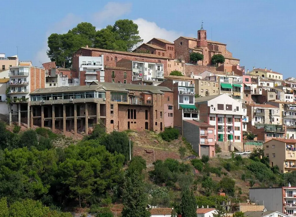
This is not a compact village gathered around a single central square. It is an elongated municipality that follows the logic of the road. The sense of movement, of passage from one comarca to another, is still present in the way the town unfolds.
The landscape that explains Vallirana
The road continues to organise the territory. The urban centre spreads along the bottom of the valley, while housing estates and former masías, traditional Catalan farmhouses, are scattered across the surrounding slopes. Walking or driving through Vallirana, there is a clear impression of a settlement that never fully consolidated into a tight core.
The valley itself is relatively wide. Fertile soil allowed cultivation for centuries. Traditionally there were cereals, market gardens and vineyards. Traces of that agricultural past remain visible in the dry stone terraces that appear along the edges of paths and fields.
The River Vallirana, with its irregular flow, crosses this agricultural space before heading towards the Llobregat. It does not dominate the landscape, but it helps explain why this strip of land was worked and inhabited for so long.
In the older areas, several historic masías survive. They can be recognised by their stone walls and carefully cut stone framing around windows and doors. Many have been renovated or absorbed into the residential growth that accelerated in the second half of the twentieth century. Even so, they still offer clues about how the territory was organised before that expansion.
Caves and watchpoints in the Garraf
The mountains around Vallirana form part of the karst system of the Garraf, a limestone landscape marked by caves, sinkholes and underground cavities. In several of these spaces, very ancient human occupation has been documented.
Cova Bonica is one of the best known sites in archaeological terms. Remains found inside point to prehistoric human presence. Without context it is not always easy to interpret what is being seen, yet the cave makes one point clear: these valleys have been inhabited for millennia. Water, natural shelter and nearby communication routes help explain that long continuity.
On nearby ridgelines, fragmentary remains of medieval towers or defensive structures can still be found. Their function was to monitor the passage between comarcas at a time when control of roads had strategic value. Today they appear as scattered traces in the landscape rather than complete monuments, but they reinforce the idea of Vallirana as a place shaped by movement and oversight.
Sant Miquel and the older centre
The parish church of Sant Miquel stands in the historic centre of the municipality. The current building is largely a reconstruction from the mid twentieth century, erected after the damage suffered during the Spanish Civil War. From the earlier church, the square-based bell tower seems to have survived. Its proportions are typical of rural Romanesque architecture.
Inside, the space is simple: a single nave, pale walls and restrained decoration. It is not a monumental church. Instead, it reflects the scale of the town at the time the reconstruction was planned. Even so, the ensemble forms one of the few spaces that evoke Vallirana before the later decades of residential expansion.
A walk through the centre helps to identify the parish church and some of the older streets. From there, it is easy to connect with paths that lead into the valley or climb towards the nearby slopes. The transition from built-up streets to open terrain happens quickly.
Between vineyards and forest tracks
Although Vallirana is now closely linked to the metropolitan area of Barcelona, the agricultural landscape remains present at the edges of the municipality. In more open zones, vineyards and small cultivated plots still appear. They connect Vallirana to the winemaking tradition of the nearby Penedès, even if the town itself has grown in a different direction.
Paths leaving the urban centre lead into the relief of Ordal and the Garraf within a short distance. A few kilometres from the centre, trails cross pine woods, former terraces and characteristic limestone formations of this massif. Underground cavities are also numerous, some of them studied by speleology groups for decades.
Not all caves are accessible without equipment or experience. The wider environment, however, suits walking and observing how relief determines land use. Agriculture occupies the valley floor. Forest and bare rock dominate the slopes. The pattern is easy to read once outside the main streets.
Getting around Vallirana
The municipality is large and fairly dispersed, so travelling by car makes things much easier. There are bus connections with Barcelona and other towns in the Baix Llobregat, though exploring on foot is largely limited to the urban centre and nearby paths.
For a first visit, a relaxed morning or afternoon is usually enough. A stroll through the centre allows visitors to locate the parish church and the older streets. From there, short excursions into the valley or up towards the surrounding hills provide a clearer sense of how geography has shaped this place.
Vallirana is best understood as a landscape structured by passage: a valley between mountain ranges, a route between comarcas, and a town that grew along the road rather than around a square. The mountains of Ordal and the Garraf, the River Vallirana and the traces of masías and caves all contribute to that story.