Full Article
about Canet d'en Berenguer
Beach destination with one of the province’s best beaches and a historic lighthouse.
Hide article Read full article
A coastal strip and an inland village
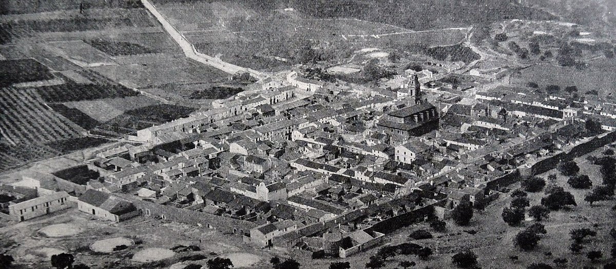
Canet d'en Berenguer is a municipality of two distinct parts: a compact historic village set slightly back from the sea, and a linear coastal strip known as the Racó de la Mar. The Canet lighthouse, built on a small rise inland from the beach, is the clearest indicator of this separation. Its location speaks to a history where the sea was a source of livelihood, not a scenic backdrop for housing.
For centuries, the main settlement kept a prudent distance from the shoreline. The coast here was shaped by the River Palancia's mouth, with dunes, wetlands, and irrigated orchards defining the landscape long before the promenade and apartment blocks appeared.
A small lordship among wetlands and reeds
The name Canet likely derives from the reeds (canyes in Valencian) that grew in the marshy areas near the river. Following the Christian conquest in the 13th century, these lands were administered by various lords. The "Berenguer" in the town's name comes from the Berenguer family, local nobility connected to nearby Sagunto, whose association with the area eventually became permanent.
By the 16th century, the settlement was small enough to be enclosed by a defensive wall of rammed earth, a response to pirate raids along this coast. Remnants of that wall are still visible, integrated into later buildings behind the church. It was a modest fortification for a modest place, where perhaps a few dozen families lived from fishing and working the irrigated land.
Iglesia de San Pedro Apóstol and a growing community
The Iglesia de San Pedro Apóstol dates from the 18th century, a period of relative stability and growth. Its architecture is a sober Baroque, typical of Valencian rural parishes of the time. The exterior is plain, while the interior holds more elaborate altarpieces and gilding.
The church's significance lies in its scale relative to the village that built it. Its construction represents an investment by a small, consolidating community. From its plaza, you can feel the proximity to the coast, just a short walk away down towards the sand.
The lighthouse and the older watchtower
The white Canet lighthouse was built in 1906 on the base of an older defensive tower. It was never meant to guide boats into a local port—Canet didn't have one—but to mark a stretch of featureless coastline between Sagunto and Almenara. This is why it stands back on a small hill, offering a view over the mouth of the Palancia and the sea.
Its light remains operational. The area around it is now a common point for a stroll, though the urbanization along the front makes it harder to see that the original village core was never here.
Looking back before tourism
The local ethnographic museum is housed in a 19th-century manor. Its most useful exhibit is a large model reconstructing Canet as it was in the 18th and 19th centuries. The model shows the walled village, the church, the surrounding orchards, and fishing boats on the beach—a clear snapshot of the dual agrarian and maritime economy.
Alongside old photographs and tools, the model provides a tangible sense of what was here before the coastal urban expansion changed everything.
Walking from the old centre to the Racó de la Mar
You can walk the historic centre in under an hour, past the church, fragments of the old wall, and some traditional houses. From there, it's a matter of minutes to reach the lighthouse area and the Racó de la Mar beach.
The beach runs for about a kilometre. Some sections retain protected dune systems. In summer, the population swells with seasonal residents, largely from Valencia and surrounding towns. Outside of July and August, the pace slows considerably, and the older rhythm of a fishing and farming town feels closer to the surface.
The lighthouse's inland position ultimately makes historical sense. Canet d'en Berenguer was not born as a seaside resort. It grew from a small settlement between marsh and sea, and its modern identity is still negotiating that geography.