Full Article
about Estivella
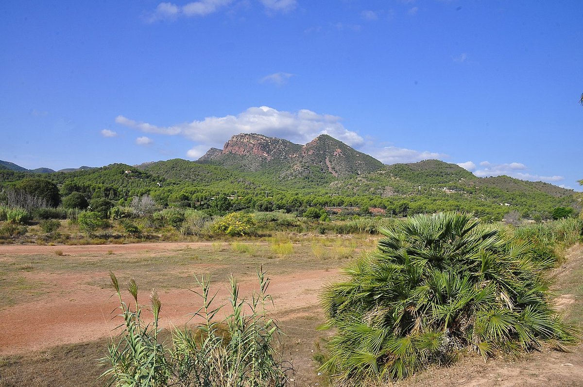
At the foot of Garbí in the Sierra Calderona, ideal for hiking up to the viewpoint
Hide article Read full article
Where the Plain Meets the Hills
Estivella lies at the western edge of Camp de Morvedre, in that subtle shift between the agricultural plain facing the Mediterranean and the first rises of the Sierra Calderona. Its setting explains much about the place. To the east stretch market gardens and citrus groves; head west from the town centre and the land begins to climb, with scrub and pine marking the approach to the hills.
Although close to Sagunto and the city of Valencia, Estivella remains tied to the rhythm of the countryside. It sits within the wider metropolitan orbit, yet the landscape is still defined by cultivated plots, irrigation channels and rural tracks. This is a municipality where agriculture shapes both the view and daily life.
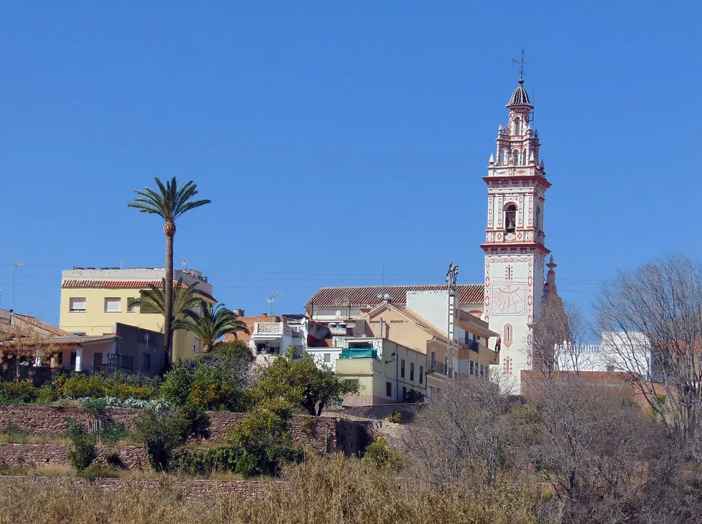
The Town and the Church of the Asunción
The urban centre is compact, with short streets and gentle slopes that follow the natural contours of the terrain. At its heart stands the parish church of the Asunción, built in the 16th century and altered in later centuries, as happened with many Valencian churches of Renaissance origin.
It is not a monumental building, but it fulfils the traditional role these churches played in farming communities: a visual landmark and a meeting point. The brick bell tower can be seen from various parts of the municipality, particularly when approaching along the tracks that cut through the orange groves.
Nearby streets still preserve houses from the late 19th and early 20th centuries. Their whitewashed façades, wrought-iron balconies and wide doorways hint at another era, when carts and agricultural tools were brought indoors at the end of the day. In some corners there are old corrals and small interior courtyards, reminders of a way of life closely linked to working the land.
The overall impression is of a town that has grown gradually, adapting to its setting rather than reshaping it. There is no grand square or monumental ensemble, but a coherent fabric that reflects its agricultural roots.
Between Huerta and Sierra Calderona
Much of Estivella’s municipal area is given over to citrus. Orange and lemon trees fill a large proportion of the fields surrounding the town, laid out according to a network of acequias, traditional irrigation channels, and rural paths. This irrigation system forms part of the historic huerta landscape typical of the Valencian region, where water management has long determined how land is divided and cultivated.
In spring, when the trees are in blossom, the scent of azahar, orange blossom, carries clearly along the paths closest to the fields. The palette shifts to white and green, a combination strongly associated with the Valencian countryside at this time of year.
To the west the scene changes. The terrain rises and pines begin to appear, along with Mediterranean scrub covering the slopes that signal the proximity of the Sierra Calderona. From some of the higher points in the municipality, on clear days, it is possible to glimpse the Mediterranean beyond the plain of Sagunto. The contrast between cultivated flatland and wooded hills is immediate, and distances are short. Within a brief walk or drive, the environment moves from irrigated orchard to hillside track.
Rural Paths and the Water Landscape
Part of Estivella’s interest lies outside the urban centre. The rural paths that circle the town link cultivated plots, small agricultural districts and trails leading towards the sierra. Many follow older routes associated with irrigation systems or access to individual fields.
Along these paths, wells, acequias and small hydraulic structures appear at intervals. Some remain in use, continuing to regulate water for the surrounding crops. Others survive as traces of how water was once organised and shared in the huerta. Together they form a working landscape rather than an open-air museum.
Walks in the area closest to the town are straightforward, with no significant changes in elevation. They lend themselves to an unhurried pace and offer a clear sense of how this agricultural setting functions. The relationship between water, plot boundaries and crops becomes visible on the ground, not as an abstract system but as something practical and still relevant.
As the paths edge westwards and the ground begins to climb, the surroundings become more wooded. Here the influence of the Sierra Calderona is stronger, and the atmosphere shifts from cultivated order to a more rugged terrain of pine and scrub.
Domestic Cooking and Local Tradition
The cooking found in Estivella belongs to the familiar repertoire of inland towns near the Valencian coast. Seasonal dishes, rice-based recipes and preparations linked to the huerta dominate. This is everyday food shaped by what is grown locally and by longstanding habits rather than by tourism.
In local homes, traditional sweets are still made. One of the best known is the coca de mida, a fermented dough sprinkled with sugar. It tends to appear during family celebrations and local festivities, maintaining a presence in communal life rather than being reserved for visitors.
The emphasis here is on continuity. Gastronomy in Estivella functions as part of daily routine, reflecting the agricultural cycle and the ingredients available at different times of year.
Estivella in the Context of Camp de Morvedre
Estivella’s location also helps make sense of the wider geography of Camp de Morvedre. A few kilometres away lies Sagunto, whose castle and Roman theatre point to the city’s importance since Antiquity. The historical weight of Sagunto contrasts with the more rural character of Estivella, yet both share the same territorial framework.
To the east, the plain opens out towards the sea and the beaches of the comarca. Coast, huerta and sierra coexist within short distances, a defining characteristic of this part of the province of Valencia. Travelling even briefly between them reveals marked differences in landscape and land use.
In this context, Estivella can be seen as a link between environments. It stands at the point where cultivated lowland meets the first slopes of the interior hills, offering a perspective on how geography shapes settlement and activity in Camp de Morvedre.
Getting There and the Best Time to Visit
From Valencia, the usual approach is via the motorway towards Sagunto, followed by regional roads heading inland. The journey typically takes around three quarters of an hour by car, depending on traffic.
Spring and autumn are generally the most pleasant times to explore the agricultural paths and move around the area without the intense heat of summer. In spring, the orange trees are in bloom, and the landscape takes on the distinctive white and green tones associated with flowering citrus in the Valencian huerta.
At any time of year, Estivella presents a setting shaped by cultivation and proximity to the hills. Its character emerges gradually, in the pattern of fields, the line of the bell tower above the rooftops and the steady transition from orchard to mountain.