Full Article
about Useras/Les Useres
Known for the Els Pelegrins de Les Useres pilgrimage; a wine-making and hiking village at the foot of Penyagolosa.
Hide article Read full article
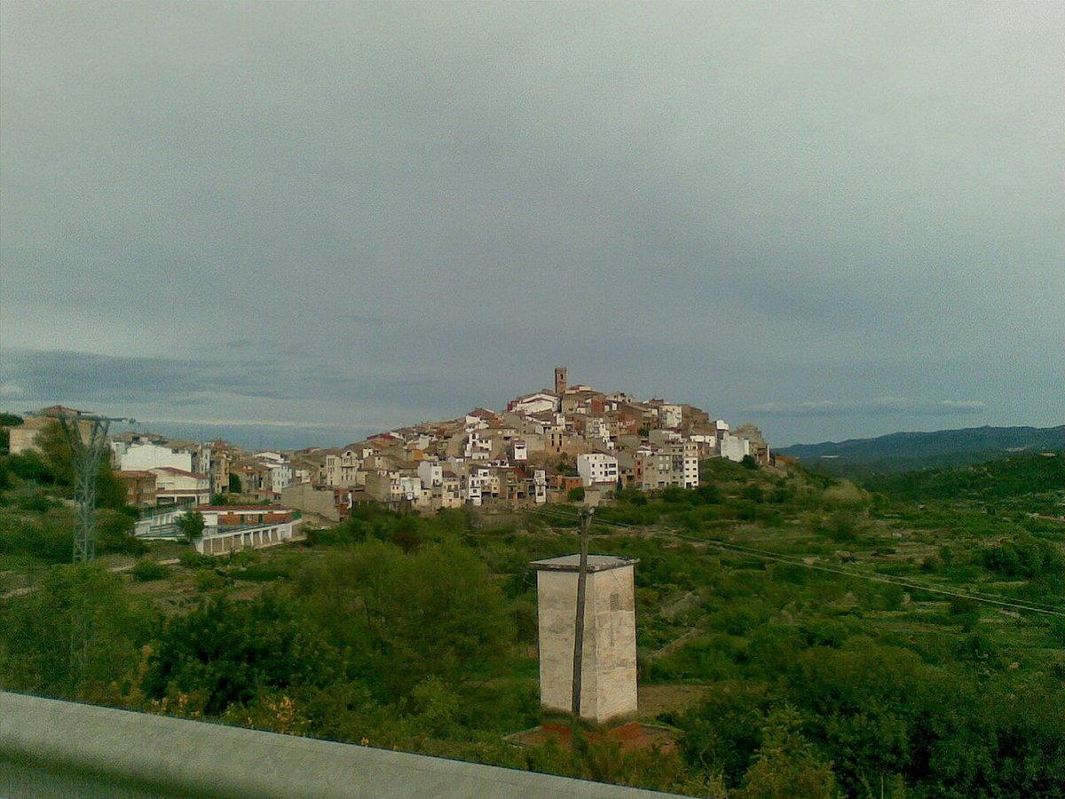
Early in the morning, when the light is still slanting and the air carries the scent of dry earth, Les Useres comes into view on the hillside with a clear outline: compact houses, reddish roofs and the pale grey of limestone all around. From the road that crosses l’Alcalatén the whole village is visible for a few seconds, before the route hides it again among almond groves and olive trees.
The municipality has around a thousand inhabitants. Daily life still follows something of the agricultural rhythm that has shaped the area for generations. Tractors pass through at first light. Shutters rise slowly. For much of the day, the streets remain quiet.
Les Useres does not revolve around major monuments or a packed tourist calendar. What it offers is simpler: a small historic centre, farmland stretching out in terraces and a network of paths that lead into the surrounding hills.
The old quarter at an unhurried pace
The historic centre can be explored without a map. Streets narrow as they climb towards the upper part of the village, and in some sections there is barely room for a car. Walls alternate between exposed stone and whitewashed façades that have changed over the years.
The parish church of the Asunción stands in one of the central spots. Its origins are usually placed in the 16th century, although later renovations explain the mix of styles visible on the façade and in certain interior details.
In a nearby square there is a stone fountain topped by a small angel, still in use. On hot days it can be heard before it is seen, the steady sound of water breaking the silence of the square.
A slow walk reveals small details. Names carved into old lintels. Wide doorways once designed for carts. Iron balconies where peppers or laundry are sometimes left to dry in the sun. None of it is arranged for display, it is simply part of everyday life.
Terraces and farmhouses in the landscape of l’Alcalatén
Beyond the built-up area, the land opens out into terraced fields supported by dry-stone walls. Olive trees and almond trees dominate the closest slopes, with the occasional carob tree among them. Dirt tracks run between the plots and connect scattered masías, traditional rural farmhouses typical of eastern Spain.
Many of these masías retain their original structure, with thick walls, sloping roofs and sheltered courtyards protected from the wind. Some are still inhabited or used for agricultural work. Others remain half hidden by vegetation.
From several higher points there are wide views across the valley of the Alcalatén. The light-coloured limestone reflects the sun strongly, particularly at dawn and towards the end of the afternoon. At those times the hillsides shift between bright whites, dark greens and the ochre of freshly turned soil.
The landscape is neither dramatic nor ornamental. It is defined by cultivation and by the practical need to make use of uneven ground, shaping it into steps that can hold trees and retain water.
Walks towards the Pi Gros
A number of waymarked trails start from the village itself, crossing this terrain of terraces and low scrub. Some routes are straightforward and follow agricultural tracks. Others head further into areas of Mediterranean brush.
One of the best-known local walks leads to the Pi Gros, a large pine tree that has become a reference point for walkers. The path passes through open stretches where the wind often moves with force.
The feel of the landscape changes with the seasons. In spring, almond trees come into bloom and the slopes are marked by white and pale pink. In autumn the air carries the smell of damp earth, dry leaves gather at the edges of the tracks and there are fewer people out walking.
Summer requires a little planning. The middle of the day can be very hot, and there are sections of the trails with limited shade. In winter, some mornings begin with low fog settled over the terraces.
These are not mountain routes in the alpine sense. They are paths shaped by agricultural use and by the steady presence of those who live and work here.
Local food and quiet tables
The cooking in Les Useres remains closely linked to what is grown or raised in the area. Rice stews are common, along with hearty spoon dishes typical of inland Valencia. Traditional embutidos, cured and prepared during the pig slaughtering season, also form part of the local table.
In homes and at celebrations, simple sweets appear: tortas, rollos and dry biscuits served with coffee. They are modest recipes that rely on basic ingredients and long familiarity rather than elaborate decoration.
There are not many places in the village to sit down for a full meal. Many visitors opt for something simple, or continue on to nearby towns afterwards. Eating here tends to be practical and unhurried, in keeping with the scale of the place.
Festivities rooted in the calendar
Throughout the year Les Useres maintains several celebrations tied to the religious and agricultural calendar. Around mid-August the main festivities usually take place, with events in the streets and the involvement of local associations.
Other traditions continue as well, such as San Antonio in winter, a celebration common in rural Spain that honours the patron saint of animals, or gatherings linked to the agricultural world in autumn.
These are not events designed as spectacles for visitors. Anyone passing through at those times simply finds village life a little more animated than usual. The focus remains local, with neighbours meeting in the streets and shared routines briefly taking on a festive tone.
Getting there and choosing the season
Les Useres lies about 35 kilometres from Castellón. The usual access is by regional road, crossing areas of scrubland and cultivated fields. Public transport services here are limited, so it is generally easiest to arrive by car.
Spring and early autumn are often the most comfortable periods for walking in the surrounding countryside. In summer the heat intensifies from midday onwards. Winter can bring mornings with low mist over the terraces.
Les Useres does not depend on grand landmarks or a busy stream of visitors. What defines it is the combination of a compact hillside village, limestone light and farmland shaped by generations. It is a place best understood at a slow pace, following the narrow streets upwards and the dirt tracks out into the fields, without expecting more than what is already there.
