Full Article
about Artana
Gateway to the Sierra de Espadán, ringed by vast olive groves; a town whose wealth of waterworks and churches still holds the soul of inland villages.
Hide article Read full article
Between Mountain and Plain
Tourism in Artana makes most sense with a glance at the map. The town lies on the southern slope of the Sierra de Espadán, within the comarca of Plana Baixa, at the point where the mountains begin to descend towards the coastal plain. The urban centre sits on a hillside at around 260 metres above sea level. Below stretch citrus groves; above rise dry terraces and the pine woods of Espadán. That contrast still shapes daily life.
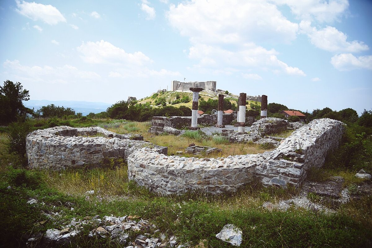
The layout of the town reflects this geography. Streets climb in short, sloping stretches, turning sharply as they adapt to the terrain. This was not a settlement laid out on a drawing board but one that expanded gradually across the hillside. The Andalusí presence in the area is often mentioned when discussing the town’s origins, and it helps to explain the irregular urban pattern still visible in parts of the old quarter.
From the higher points in Artana, the setting becomes clear. Behind stand the peaks of Espadán; ahead spreads the agricultural plain that extends towards the coast. Generations have worked this landscape, and that long relationship between people and land remains easy to read.
Parish Church and Hillside Streets
At the heart of the town stands the parish church of the Asunción. The current building dates from the eighteenth century and follows the Baroque style that spread through many Valencian villages at the time. Its tower is visible from different points across the municipality and acts as a clear reference as you approach. Inside, the church preserves altarpieces and decoration linked to the popular religious traditions of the comarca, although access depends on parish opening times.
The slope becomes more pronounced in the area known as the Barrio Alto. Houses here adapt closely to the incline, using practical solutions suited to agricultural communities. Many are narrow in plan, with stone or rubble masonry walls, and some older properties retain arched doorways. This is not monumental architecture, but it offers a direct sense of how homes were built in the farming villages of this part of the Valencian interior.
Artana connects quickly with the surrounding landscape. A short walk from the urban centre leads to paths that pass through pine woods, abandoned terraces and plots still under cultivation. The mix of farmland and scrubland is typical of this sector of the Sierra de Espadán and underlines the gradual transition from village to mountain.
Close to the town lies the Fuente de los Chorros, a spring known to local residents for generations. Traditionally it has served as a stopping point along the routes that climb towards the sierra. The setting is simple, with riverside vegetation and shade. It is somewhere to pause briefly rather than a place designed for a full day out.
Paths Through Citrus and Stone
Walking in the surroundings helps explain how the territory has been organised. Many footpaths follow former agricultural routes that once linked orchards, corrals or small scattered farmsteads within the municipal boundaries.
In the lower areas, citrus groves dominate. They form an essential part of the economy of Plana Baixa and define the landscape around Artana. As the ground begins to rise, olive trees and almond trees appear, along with terraced plots supported by dry stone walls. These bancales show the effort required to cultivate uneven terrain and remain one of the clearest marks of human adaptation to the hillside.
The appearance of the landscape changes noticeably with the seasons. In spring, the contrast between the orange groves and the sierra is particularly striking. During summer, the mountain takes on drier tones and the relief appears harsher. Some sections of the paths retain earth surfaces with loose stones, so suitable footwear is advisable for those exploring on foot.
The relationship between agriculture and mountain terrain defines much of Artana’s character. The lower fields tie the town to the wider citrus plain, while the upper slopes connect it to the wooded heights of Espadán. Moving between these zones involves only a short distance, yet the shift in atmosphere is clear.
Festive Calendar in the Valencian Interior
Artana’s festive calendar reflects traditions that remain common across inland parts of the Valencian Community. In August, the town celebrates its patronal festivities in honour of the Virgen de la Asunción. These days bring together processions, religious ceremonies and activities organised by local peñas and associations. The focus is communal, with events concentrated in the streets and squares of the town.
January usually sees the celebration of San Antonio Abad. A traditional bonfire forms part of the occasion, along with the blessing of animals. Participation from residents remains strong, and the event maintains a character closely tied to rural custom.
Holy Week is also marked in the streets of the old quarter. Processions pass through the central stretches of the town, using the sloping routes that define its layout. Around May, the feast of San Isidro recalls the town’s historical link with agricultural work. San Isidro is widely recognised in Spain as the patron saint of farmers, and his celebration here fits naturally with Artana’s farming background.
These events do not transform the town into a large festival destination. They continue, instead, as part of a local rhythm shaped by parish life and agricultural tradition.
Getting There and Moving Around
Artana lies inland within the comarca of Plana Baixa, a short distance from towns such as Onda and Nules. Access is via a regional road that links the citrus plain with the first foothills of the Sierra de Espadán.
The urban centre can be explored on foot without difficulty, although some streets are steep. Those who plan to follow the paths into the sierra are advised to leave the car in the lower part of the town and continue walking.
Artana does not present itself through grand monuments or large-scale attractions. Its interest lies in the meeting point between mountain and plain, in streets that climb according to the shape of the land, and in fields that still show how much work has gone into shaping them. The combination of citrus groves below and pine-covered slopes above continues to define both the view and the pace of life.

