Full Article
about Ladrillar
Border municipality with Salamanca deep in Las Hurdes; wild nature
Hide article Read full article
First light in a quiet valley
Early in the morning, when sunlight starts slipping between slate rooftops, Ladrillar is still half asleep. Low light brushes the stone walls and picks out the uneven granite, the repairs, the dark joints. A gate clicks somewhere in a yard, and a cool, damp smell drifts down from the hills into the valley air. Tourism in Ladrillar often begins like this, slowly, on foot, in a village that barely stirs at that hour.
Ladrillar sits at the northern edge of Las Hurdes, in the province of Cáceres. It keeps the rhythm of a small place where almost everything is within walking distance. The streets are narrow, with cobbled stretches and slopes that naturally slow your pace. Wooden windows, many left unpainted, reveal flowerpots or laundry hanging out to dry.
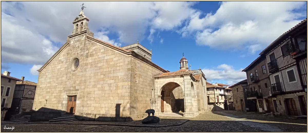
The parish church stands in one of the more open parts of the village. It is modest in size. Its stone façade shows repairs from different periods, and inside there are dark wooden beams worn by time. The building feels shaped by endurance and adaptation rather than display.
Stone houses and gardens by the path
A short walk through Ladrillar makes it clear how the village has adjusted to its terrain. Houses lean into one another along the hillside, with thick walls and steep slate roofs. Some balconies hold short beams, darkened almost black by sun and rain.
Behind many homes are small kitchen gardens. In summer, tomato plants, peppers or a vine shading the entrance are common sights. Goats and sheep often move along nearby paths, and sometimes pigs can be seen in open pens on the outskirts. Here, the countryside is not just scenery. It remains part of daily life.
Paths through ravines and woodland
The landscape around Ladrillar is densely covered in places. Oaks and chestnut trees dominate, with thick undergrowth that carries the scent of damp leaves in autumn. Between these slopes run narrow ravines, or gargantas, where water flows quickly after rainfall.
Footpaths link Ladrillar with other hamlets and villages in the region, including Riomalo de Abajo and Caminomorisco. Some sections follow the water’s course and pass natural pools formed between smooth rocks. In summer, many people head down to these spots to cool off after walking. Even on the hottest days, the water tends to stay cold.
Sturdy footwear is a good idea. Some paths are uneven, and after rain the stone can become slippery.
Gathering from the hills
In spring and autumn, it is common to see people heading into or out of the woods with baskets. Mushroom and chestnut picking are part of the seasonal rhythm in many villages across Las Hurdes. For those unfamiliar with local species, it is best to ask first or simply observe. In the area, there is a strong emphasis on not picking what cannot be clearly identified.
The hills are also home to beehives. On mild days, a steady hum can often be heard in open clearings.
Food shaped by the surroundings
Local cooking reflects what the land provides. Goat meat, cured sausages prepared in winter, and honey from nearby hives are typical ingredients. Migas appear on many tables when the weather turns cooler. This dish is made with stale bread, oil and whatever ingredients are available that day.
These are filling meals, usually eaten slowly after a morning spent outdoors.
Festivals that follow the village calendar
In summer, around San Bartolomé, the village becomes livelier than usual. Streets fill with music and processions that move through the old centre. Tambourines, bagpipes and jotas, a traditional style of music and dance, are still part of the celebrations, often performed in circles as evening falls.
Winter brings San Antón, traditionally linked to animals. Residents and farmers gather with goats, donkeys or sheep for a blessing. It is not a large event, but it maintains a long-standing custom found in many mountain villages.
When to visit Ladrillar
Between spring and autumn, the hills are at their most inviting for walking. In May, everything turns green, while in October chestnut trees begin to change colour.
Summer days are best approached early in the morning or later in the afternoon, as midday heat tends to settle in the valley. In winter, it is worth checking the condition of mountain roads, since cold and damp weather can make some stretches difficult.
Ladrillar has no grand monuments or streets designed for photographs. What matters here lies in the details: the sound of water running through a garganta, the dense shade of chestnut trees, the smell of wood smoke as evening sets in. Everything happens on a small scale, and it only reveals itself when the pace slows.