Full Article
about Garrovillas de Alconétar
It has one of Spain’s largest and most beautiful arcaded main squares; a striking ruined convent.
Hide article Read full article
A village that slows you down
Some places force you to change pace without warning. You park the car, walk two streets and realise you are already moving more slowly. Tourism in Garrovillas de Alconétar works a bit like that. Not because there are headline monuments every few metres, but because the atmosphere draws your attention to small details: a patch of shade beneath the arcades, an oversized wooden door, neighbours chatting in the square as if the clock were of little concern.
Garrovillas de Alconétar lies around 60 kilometres from Cáceres, in the Tajo‑Salor comarca of Extremadura. About two thousand people live here. Open countryside stretches out around the village, with dehesa pastureland nearby and the waters of the River Tagus shaping the wider landscape. There is no sense of a purpose-built tourist setting. This is a working village that remains very much itself.
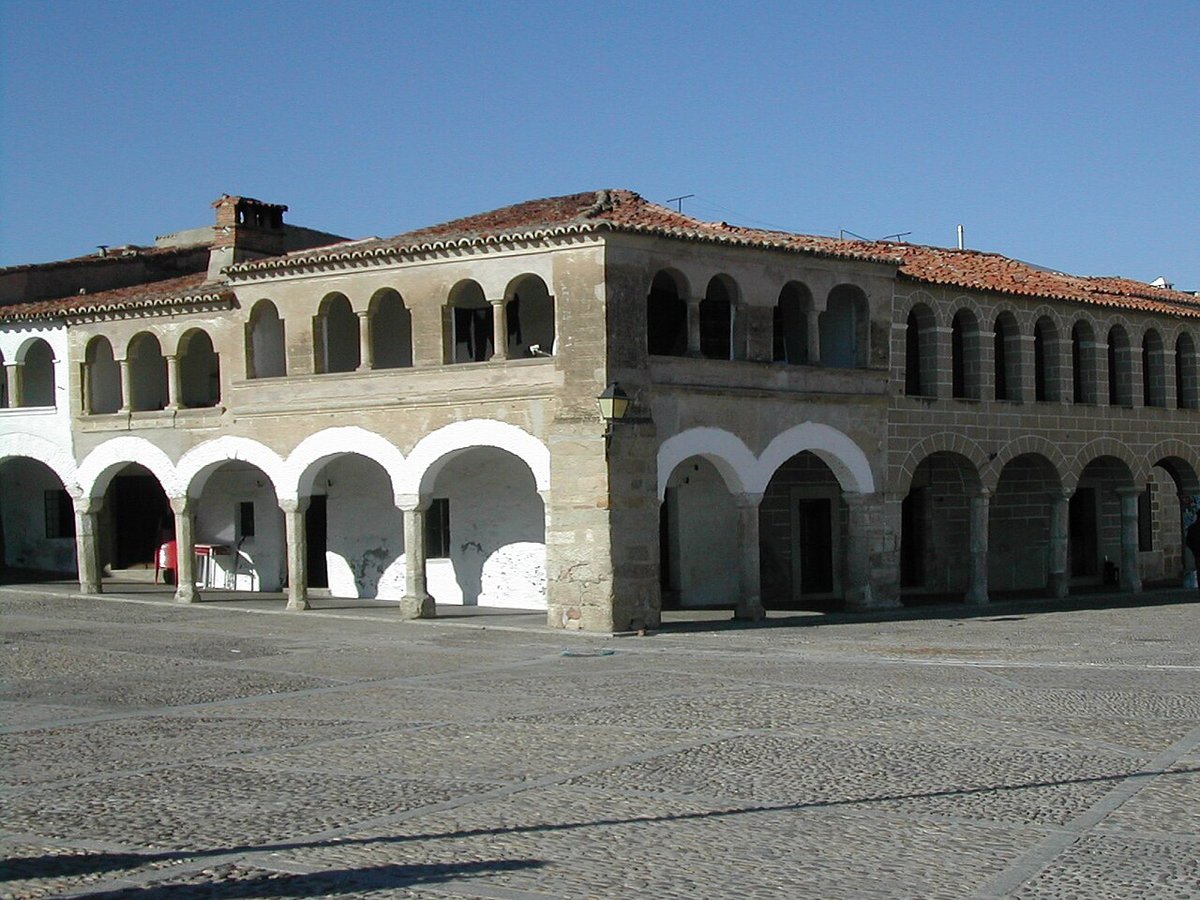
The Plaza Mayor at the centre of it all
Arrive for the first time and you will almost certainly end up in the Plaza Mayor without trying. It happens naturally.
The square is large, far larger than many expect in a place of this size. Arcaded on its sides, with long porticoes and buildings that seem to watch what unfolds below, it carries the air of a space that has served many roles over the centuries. Markets have taken place here, along with celebrations and everyday encounters.
Sit for a while and the rhythm of the village becomes clear. People drift in and out of the arcades. Someone crosses the square greeting half a dozen neighbours. A bench is always occupied. In a setting like this, simply looking around becomes part of the visit.
For readers unfamiliar with Spanish town planning, the Plaza Mayor is often the social and architectural heart of a community. In Garrovillas de Alconétar, that role feels intact rather than preserved for show.
San Pedro Apóstol, the constant landmark
The church of San Pedro Apóstol is the visual reference point of the old quarter. If you wander through the streets and lose your bearings, which happens easily, lift your eyes and look for the tower.
Construction began towards the end of the Middle Ages and the building accumulated additions over the centuries. From the outside it presents solid stone and a robust volume. Inside, Baroque altarpieces and other features reflect the long history of the place.
It is not an overwhelming monument in the grandest sense. Its presence is quieter, more in keeping with the scale of the village. Yet it anchors the historic centre and gives shape to the surrounding streets.
Those streets are easy to explore in a short time, but they reward a slower pace. They are narrow, lined with thick-walled houses and large gateways that hint at interior courtyards hidden from view. Now and then a more imposing residence appears, with a stone coat of arms on the façade or architectural details dating back to the 16th century. These houses recall a period when certain families held considerable influence in the area.
The historic centre is not vast. Even so, it offers enough detail to justify an unhurried walk spent looking up at façades and noticing how little some things appear to have changed.
The memory of the Puente de Alconétar
The name Garrovillas de Alconétar comes from the ancient Puente de Alconétar, a Roman bridge that for centuries allowed travellers to cross the Tagus in this part of the Iberian Peninsula. It formed part of important routes linking the western territories.
Today the bridge is not always visible. After the construction of the Alcántara reservoir, much of it was submerged. When water levels drop significantly, some remains emerge once more. The sight can be striking: Roman arches rising from within a modern waterscape.
Even when hidden beneath the surface, the bridge remains present in local memory. It explains the village’s name and forms part of its historical identity, even if visitors may not always see it.
The nearby landscape reflects this relationship with water. The Tagus and the reservoir sit close to the village, shaping both scenery and wildlife.
Between dehesa and water
Step beyond the urban centre and the Extremaduran dehesa appears. This distinctive landscape of open pasture dotted with holm oaks defines much of the region. Paths cross the terrain, used by residents and by those who come simply to walk.
Near the river and the reservoir, birdlife is easy to spot depending on the season. Storks and herons are among the species that take advantage of the calm shores and available water. No elaborate excursion is required. A short walk with a little attention is enough to appreciate what makes this setting characteristic of this part of Extremadura.
The overall impression is straightforward rather than dramatic. Fields, water and sky combine in a way that feels typical of the Tajo‑Salor comarca. For travellers unfamiliar with the dehesa, it is a working rural landscape rather than a manicured park, shaped by agriculture and tradition.
Food rooted in tradition
Local cooking keeps to the essentials. Stews made with lamb or kid goat are common, especially in cooler weather. Migas, a traditional dish based on breadcrumbs, often appear when temperatures drop. Bread, olive oil and produce from the surrounding countryside play a central role.
There are no elaborate inventions here. The emphasis falls on long-established recipes that fill the table and encourage conversation to continue after the meal. In Garrovillas de Alconétar, eating slowly makes sense.
In the end, this is the kind of place you might not reach by chance. Yet pause for a morning, a leisurely lunch or a walk across the Plaza Mayor and the different elements begin to fit together. The square, the church of San Pedro Apóstol, the memory of the Puente de Alconétar, the dehesa and the Tagus all form part of a coherent whole. What seems simple at first gradually reveals its logic.