Full Article
about Navas del Madroño
Town on the rolling plain with big-chimneyed architecture and a livestock-farming setting
Hide article Read full article
A landscape that sets the tone
Tourism in Navas del Madroño begins with the landscape rather than any single monument. The village sits in the Tajo‑Salor area, a stretch of open dehesa where holm oaks, cork oaks and strawberry trees have coexisted for centuries. These scattered woodlands are not wild in the strict sense. They are shaped by long use, combining pasture with tree cover in a way that defines much of western Extremadura.
The name Navas del Madroño comes from the madroño, or strawberry tree, a shrub that still appears across the surrounding countryside. It has traditionally been used for homemade liqueurs and other domestic purposes. The reference is not decorative. It reflects a plant that people knew well and made use of.
This is not a place that features prominently on the busiest regional routes. That distance from major tourist flows helps explain the pace of daily life, which remains easy to recognise and largely unchanged in its rhythms.
A square shaped by use
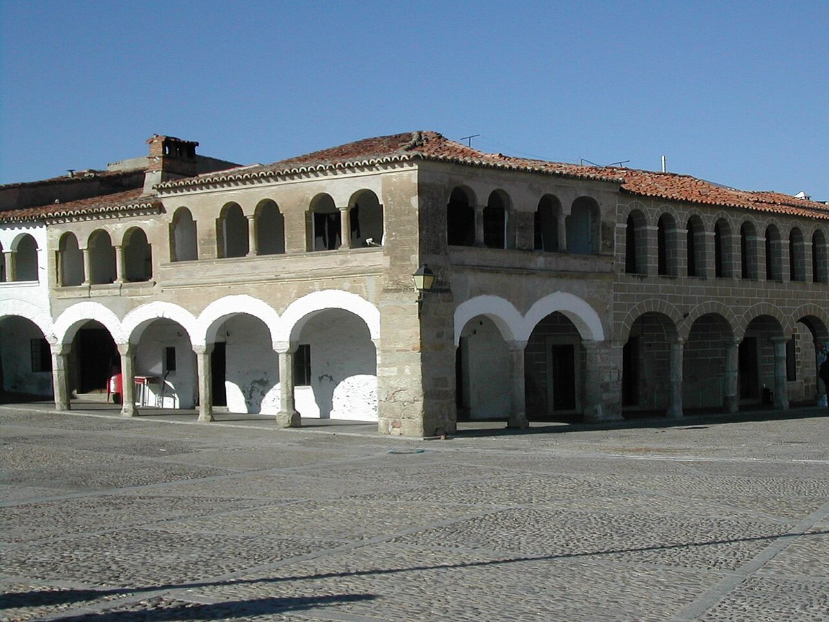
The centre of Navas del Madroño gathers around the Plaza Mayor. It is not the neat, rectangular square often associated with towns in Castile. Instead, it developed gradually, adapting to the terrain and to buildings as they appeared over time.
The town hall stands on a granite arcade that has long provided shelter during market days or bad weather. The structure dates to around the 17th century, though it has been altered since. The arches are not perfectly aligned, which gives a clear sense that practical needs mattered more than strict design.
From the square, Calle Real leads towards the parish church of Nuestra Señora de la O. The current building largely belongs to the 18th century. Its dedication links to the Advent antiphons known as the “O antiphons”, traditionally sung in the days leading up to Christmas. Inside, a Baroque main altarpiece holds several sculptures. These works speak more about local forms of devotion than about grand artistic ambition.
The area around the square, together with a handful of nearby streets, concentrates most of the village’s historical interest. It is compact and easy to explore without needing a fixed route.
Santo Domingo and the spring gathering
On the outskirts, in the direction of Brozas, stands the hermitage of Santo Domingo de Guzmán. It is a modest building, constructed in masonry with some reinforcement in dressed stone. This combination of materials is typical of rural hermitages in Extremadura from the 16th century onwards.
The presence of Santo Domingo here does not suggest a direct connection with the saint’s life. Instead, it reflects the spread of Dominican devotion during the reorganisation of territory that followed medieval repopulation.
The hermitage is closely linked to a local romería, a traditional gathering that usually takes place around Easter Sunday. On that day, the surrounding countryside fills with families who spend time outdoors together. This custom remains firmly rooted in villages across this part of Cáceres, especially when spring arrives and the weather encourages time in the open.
Following the Ruta de las Chimeneas
One of the more distinctive routes starting from Navas del Madroño is the Ruta de las Chimeneas. It connects with nearby towns such as Brozas, Arroyo de la Luz and Malpartida de Cáceres, following old livestock paths that once structured movement across the region.
The name refers to industrial chimneys that still appear along certain stretches. These are the remains of small 19th century textile factories linked to linen and wool production. Most of what survives today are partial or ruined structures, yet they point to a period when the local economy was not based solely on livestock.
The route crosses dehesa landscapes where cattle graze and, depending on the season, Iberian pigs as well. Walking at a steady pace often brings encounters with wildlife. The experience changes noticeably in spring, when the undergrowth fills with flowers and the fields turn an intense green that lasts only a short time in Extremadura’s climate.
Water and its uses
A few kilometres away, already within the boundaries of Brozas, lies the San Gregorio spa. Its waters have been known for a long time and were probably used in earlier periods, although organised thermal activity developed much later. People from nearby villages traditionally visited these waters for their therapeutic qualities.
Water has also been an important resource within Navas del Madroño itself. The spring that supplies the village has allowed it to maintain water availability even during dry summers. In an area dominated by dehesa, where water can be scarce, that reliability has always carried weight.
Cooking from the surroundings
Local cooking reflects what the land provides. Bread, lamb, Iberian pork and products from traditional pig slaughter continue to shape many recipes.
Migas appear regularly, especially during family gatherings or days spent outdoors. Caldereta de cordero, a slow-cooked lamb stew, is another familiar dish prepared for celebrations and shared occasions.
Sweet recipes also hold their place. Pestiños, roscas de vino and hornazos are still made and are commonly seen during fairs and festivities throughout the local calendar. These are not elaborate creations but recipes that have been passed down and repeated over time.
Getting there and when to go
Navas del Madroño is around a three-quarter-hour drive from Cáceres along the EX‑390, a regional road that passes through dehesa landscapes and small livestock farms.
The village itself can be explored in a relatively short time. The main square, the church and nearby streets form the core of its historical area. From there, it is easy to head out towards the hermitage or to follow paths that extend into the surrounding countryside.
Spring and autumn tend to offer the most comfortable conditions for moving around the area. The landscape shifts with the seasons, and these periods bring milder temperatures along with more visible changes in the fields and vegetation.