Full Article
about Vilar de Santos
Hide article Read full article
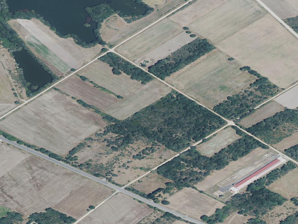
A Plain Shaped by Water
Vilar de Santos lies inland in the province of Ourense, within the comarca of A Limia. This is a territory defined by wide agricultural fields and by the memory of the former Laguna de Antela, a vast wetland drained in the mid 20th century. The municipality has around 800 inhabitants. Its appeal does not rest on a single landmark or historic quarter, but on the way its farmland and scattered villages tell the recent story of this part of Galicia.
For centuries, A Limia was a plain governed by water. The Laguna de Antela covered a considerable area and dictated how the land could be used. When the lagoon was drained, the transformation was decisive. Drainage channels cut across the terrain, rectangular plots replaced older divisions, and farming became far more intensive. Vilar de Santos forms part of this reordered landscape: open fields, straight roads and villages that still preserve a structure dating from before those changes.
The local architecture reflects a direct, practical rural economy. Stone houses with simple volumes stand alongside wide gateways built for agricultural work. Hórreos, traditional raised granaries typical of Galicia, remain in place. Some are still used, others stand empty. Public washhouses, once everyday meeting points, can still be found. Stone cruceiros, wayside crosses erected at crossroads or in small squares, mark the traditional organisation of the territory and its religious references.
Scattered Villages and Everyday Architecture
Vilar de Santos does not have a compact historic centre. Like many places in A Limia, it consists of a group of small villages linked by local roads and rural tracks. In some cases, only a handful of houses cluster around a church or a modest square.
A walk through these settlements reveals details that are easy to miss from a car. Irregular stone boundary walls outline smallholdings. Large entrances open onto former eiras, threshing floors where agricultural tasks once took place. Hórreos often line up beside the houses, reinforcing the close relationship between home and field. None of these elements is exceptional on its own, yet together they explain clearly how life here was organised.
Parish churches usually occupy the central point of each village. Many have ancient origins, although the current buildings have often been altered over time. Outside religious services they are frequently closed, which is common in small rural communities. Even so, their presence continues to define the symbolic centre of each settlement.
The Mark of the Laguna de Antela
No sheet of open water remains today, yet the former Laguna de Antela still shapes the landscape. The drainage channels, the broad plots and the marked horizontality of the terrain all stem directly from the decision to eliminate the wetland.
The municipality is home to the Centro de Interpretación da Lagoa de Antela. This interpretation centre explains what the wetland was like, why it was drained and how the local economy changed as a result. A visit provides useful context before or after walking the area’s rural paths, offering a way to read the landscape with greater understanding.
On clear days, the sheer breadth of the plain becomes strikingly apparent. The horizon stretches across cultivated land with few interruptions. When fog rolls in, something that happens regularly in A Limia, visibility can shrink to just a few metres. In those conditions the atmosphere changes completely, and it becomes easier to imagine how this place might have felt when water dominated the plain.
A Landscape Best Understood on Foot
Vilar de Santos does not lend itself to ticking off monuments. A more rewarding approach is to choose one or two villages and walk the tracks that connect them, always respecting inhabited houses and working farmland.
The interest lies in the layout of the plots, the stone walls that define them and the relationship between dwellings and the surrounding fields. The land tells its story through form rather than spectacle. Late in the afternoon, as the sun lowers over the plain, the tones of the soil and crops shift noticeably. Light brings out subtle relief in what at first glance appears to be completely flat terrain.
Seasonal changes also alter the impression of the area. Fields move through different stages of cultivation, and the open setting makes these transitions visible across large distances. The rhythm of agricultural work remains central to the identity of the municipality.
When to Visit and What to Bear in Mind
Spring and autumn are generally the most comfortable times for walking in the area. Temperatures tend to be moderate, and the fields are in varying phases of growth. These seasons allow longer walks without the intensity of summer heat.
Summer brings strong midday sun, something typical of the A Limia plain. Early mornings and late afternoons are usually more suitable for exploring on foot. Winter is colder and often damp. After several days of rain, some dirt tracks can become slippery.
Expectations matter in Vilar de Santos. Arriving in search of a monumental village can lead to disappointment. The value of the place lies in its agricultural landscape and in the way its villages are arranged, rather than in singular buildings.
Wind is another factor to consider. In such an open plain, the perceived temperature can feel lower than the thermometer suggests. After recent rainfall, some rural tracks may be difficult to negotiate by car. In many cases it makes sense to leave the vehicle on firm ground and continue on foot.
Practical Orientation
From the city of Ourense, access is usually by road via Xinzo de Limia, which functions as the main hub of the comarca. Within the municipality itself, distances are short, but the scattered layout means that moving between villages requires using local roads.
Vilar de Santos rewards a slower pace. Its story is written across fields, drainage channels and stone-built villages that predate the reshaping of the plain. Those willing to look beyond the absence of headline sights will find a landscape that reflects one of the most significant environmental transformations in modern Galicia, still visible in the geometry of the land and the everyday architecture of its settlements.

