Full Article
about A Laracha
Hide article Read full article
Where the Motorway Slows Down
There is a precise moment on the AG-55 when the motorway gives up its straight lines and becomes a local road. The air changes. It carries the smell of the sea mixed with cabbage from the surrounding fields. This is not poetic exaggeration, it is agriculture meeting Atlantic breeze. Around A Laracha, crops stretch out towards the coast, and in the distance lies the port of Caión.
For many drivers heading towards places such as Laxe, A Laracha is little more than a name glimpsed on a road sign. It is easy to assume it is a crossroads rather than a destination. Yet this municipality, one of the largest in the Bergantiños region of Galicia, has more going on than first impressions suggest.
A Laracha does not compete for attention. It does not present itself as a picture-postcard coastal town. Instead, it carries on as a place where people live and work, where fields are planted and harvested as they always have been. Tourism exists here, but it does not dictate the rhythm.
A Municipality With a Quiet Advantage
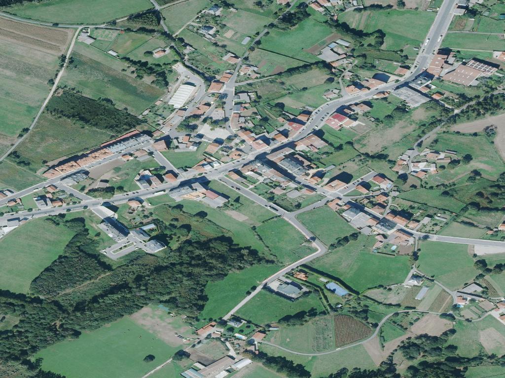
The municipal capital of A Laracha looks, at first glance, functional. A junction of roads, a town hall, a health centre, a few bars where coffee is served strong and without ceremony. It is officially the centre because the map says so, not because it performs for visitors.
That is part of its appeal. While other coastal towns polish their façades, A Laracha remains straightforward. The AG-55 cuts through the municipality like an artery, providing access to a territory that widens inland into hills planted with eucalyptus and narrows towards the Atlantic at the peninsula of Caión.
The sea is the surprise. From the interior, you would not guess how strongly the coastline shapes this municipality. It only becomes apparent as you draw closer, when the land funnels you towards granite and open water.
Climbing to Santa Marta
One of the clearest ways to understand A Laracha is to head uphill. The route to the Mirador de Santa Marta is marked as a “trail” on digital maps, yet in reality it is a forest track where old cars pass cautiously and neighbours walk with shopping bags or rucksacks.
From the municipal capital, the road towards Cerceda narrows steadily. Two cars can pass, but with care. In Soutullo there is a turning that is easy to miss: a patch of earth, a slightly worn sign reading “Mirador” and an arrow pointing uphill.
The climb is short, a couple of kilometres of bends. At just over 400 metres above sea level, the landscape opens abruptly. The Atlantic appears in full, stretching from Caión towards the area of Malpica on clear days. Cliffs carve the coastline into sharp lines. The sense of space is immediate.
At the top there is a concrete bench. On Sundays, local residents sit there to eat sandwiches or simply look out at the horizon. It is an unadorned viewpoint, but it changes your understanding of the place. From here, A Laracha is no longer a name on a sign but a defined stretch of land between hills and ocean.
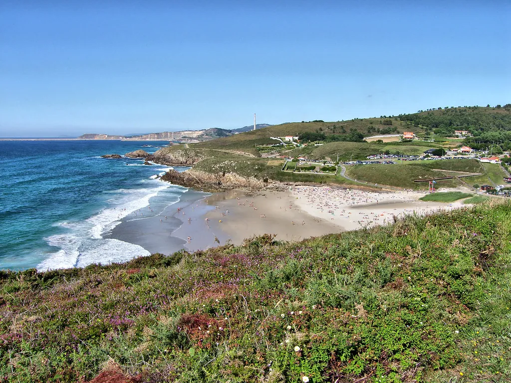
Caión: A Working Port on the Atlantic
If Santa Marta provides perspective, Caión delivers the sea up close. The port of Caión is not designed as a backdrop for photographs. It is a working harbour, with cranes, nets and boats that smell of diesel and salt. Fishermen call to one another from vessel to vessel. Activity here is practical and direct.
The peninsula itself is a tongue of granite pushing into the Atlantic, creating two distinct environments. On one side there is a sandy beach exposed to the open sea. On the other, a rockier area where waves strike stone and the sound carries, especially when the wind rises. In blustery weather the surf can be heard from a distance.
There are no grand seafront promenades or rows of new hotels. A small car park fills with people who come to sit, watch the water and eat something simple before leaving again. The setting does not require embellishment. Sea and stone are enough.
In summer, Caión draws more visitors. The car park fills quickly and the beach becomes busier on clear days. Even then, it remains calmer than many other parts of this coastline. Outside the peak months, the rhythm slows back to that of a working fishing community.
San Pedro de Soandres and the Interior
Away from the coast, the parish of Soandres holds one of the municipality’s most significant historic buildings: the monastery of San Pedro de Soandres. From a distance it might appear to be another rural church. Up close, the stonework reveals details that speak of centuries of history.
For a long period it played an important role in the religious life of the area. On Sundays there is still movement around the site, with people arriving from nearby parishes. The complex stands at the foot of Monte Pedrouzo, surrounded by meadows and scattered houses. Silence feels like part of the setting.
The high-speed rail line passes relatively close to this area. When it first began operating, local residents say the noise drew attention. Over time it has faded into the background, becoming just another layer of sound, like the sea for those who live along the coast.
Fitting A Laracha Into a Route
A Laracha shifts with the seasons. In spring, cultivated fields around the villages form a green patchwork that moves with the wind. In autumn, the hills carry the scent of damp earth and mushroom foragers appear, people who know exactly where to look.
Summer concentrates activity in Caión. Clear days bring more movement to the beach and harbour. Even so, the municipality retains a sense of proportion. It never feels overwhelmed.
This is not a place that demands a tightly planned weekend. A Laracha works best as part of a wider journey through Bergantiños and the Costa da Morte, or as a deliberate pause between better-known stops. It rewards those who slow down, take the smaller road and follow the sign that points uphill to a viewpoint with a concrete bench.
The surprise lies in its lack of spectacle. Fields, forest tracks, a granite peninsula and a monastery at the foot of a hill. None of it shouts for attention. Yet together they form a stretch of Galicia that feels grounded and lived-in, where the motorway may pass through but does not define what remains on either side.