Full Article
about Meira
Hide article Read full article
Where the Miño Begins
Tourism in Meira usually starts at the same spot: the Pedregal de Irimia, traditionally considered the source of the River Miño. At more than seven hundred metres above sea level, there is nothing monumental about it. Water seeps out between rounded stones, moss and ferns, barely a thread that begins to slip downhill.
It is a modest beginning for the longest river in Galicia. Yet the setting helps explain why Cistercian monks chose this valley in 1142. The river meant water and a natural route through the landscape. The surrounding countryside offered the solitude they sought.
The Pedregal de Irimia lies a few kilometres from the town. Access is via a forest track followed by an easy walk. There are no large structures or visitor centres waiting at the end. Just a discreet sign and the steady sound of water starting its course towards the Atlantic.
The Monastery That Shaped the Town
The church of Santa María is one of the clearest examples in Galicia of Romanesque architecture influenced by Burgundy, introduced by the Cistercian order. It does not try to dominate its surroundings. The building is austere, guided by the constructive logic of an order wary of excess.
Inside, three naves are arranged side by side, separated by columns. Ribbed vaults were added later, in the 13th century. In the apse, fragments of mural painting still survive.
The consecration of the church in 1258 was a significant event for the area. Martín, Bishop of Lugo, gathered much of the local nobility here. For centuries the monastery shaped life across the valley.
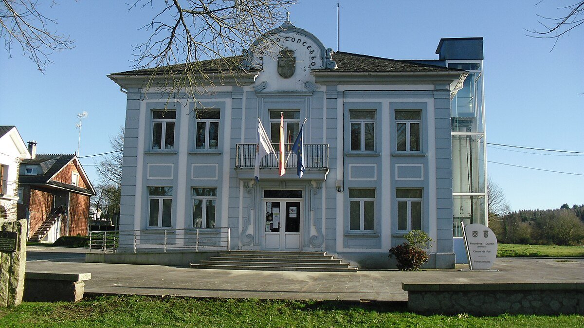
Everything shifted in 1835 with the Desamortización, the 19th-century confiscation of Church property in Spain. The monks left the monastery and the complex lost its original function. Even so, the layout of the town still revolves around that enclosure. In the main square, several arcades from the former Renaissance cloister remain, now incorporated into the town hall building. They are few in number, yet enough to suggest the scale the monastery once had.
Thirty-Eight Villages and One Centre
The municipality of Meira covers just under fifty square kilometres and is divided into dozens of small villages and hamlets. The main town acts as the administrative and commercial centre. Historically, daily life across the territory was always dispersed. Chapels, stone crosses known as cruceiros, and isolated houses stand between meadows and fields.
The average altitude is around five hundred metres. The terrain is generally gentle, although higher peaks rise nearby. Pico do Forno de Martín approaches one thousand metres. On a clear day it offers views over the upper Miño valley and the patchwork of meadows where livestock is still raised. The climb requires some effort, but there is no technical difficulty along the route.
Before modern roads were built, the Miño also functioned as a line of communication. Timber, stone and other goods moved along the valley towards different parts of the province of Lugo. Pilgrims crossing this area of Galicia often followed the river’s course.
Today, a short riverside walk traces part of that environment. It is a quiet path that follows the water between alders and damp meadows. The whole territory forms part of the Terras do Miño Biosphere Reserve, recognised by UNESCO at the beginning of this century.
The Rhythm of Work and Weather
At the end of August, Meira changes pace for a few days during the Festa da Malla. This celebration recalls how cereal was threshed before mechanisation transformed agricultural work. Horses and mules tread the straw on the threshing floor while local residents recreate the task as it was once carried out in surrounding villages.
The festival functions less as a spectacle for outsiders and more as an act of collective memory. Many of those who take part grew up watching this work in the aldeas. For them, it is not distant history.
For the rest of the year, the atmosphere is calm. In winter, fog often lingers in the bottom of the valley until mid-morning. The pace of daily life remains slow. Local bakeries continue to prepare recipes closely associated with the area. One is empanada de manzana, made with bread dough rather than pastry. Another is the well-known bola de liscos, filled with pancetta.
Practical Notes for a Visit
Meira lies in the north of the province of Lugo, connected by regional roads that cross woodland and pasture. The most common access is via the LU-540.
Anyone heading to the Pedregal de Irimia or exploring nearby paths should wear closed footwear. The weather in this part of Galicia changes quickly, and a light waterproof often proves useful, even on days that begin clear. Above all, it helps to arrive without rushing. The rhythm of Meira remains unhurried, shaped by the river that begins here as little more than a narrow stream between stones.