Full Article
about Pedrezuela
Mountain town beside the reservoir; it keeps its medieval charter and traditional architecture.
Hide article Read full article
A place shaped by routes and river
Pedrezuela sits in the Cuenca del Medio Jarama, where the valley of the Guadalix begins to open out before the mountains take over. For centuries, this was a point of passage between the lands of Guadalajara, Segovia and the interior of Madrid. That role as a crossroads explains much about how the settlement came to be.
In 1331, Alfonso XI granted a Carta Puebla, a formal charter used in medieval Spain to establish and organise new communities. It recognised a settlement that already made practical sense: a bridge over the river and a network of routes converging in the same place. Movement and connection came first, and the village grew from there.
Today, Pedrezuela has more than six thousand inhabitants and forms part of the northern belt of Madrid, with much of its daily rhythm linked to the capital. Even so, parts of the landscape still point to an earlier way of life. Shepherds’ constructions scattered across the hills and the reservoir occupying the valley both hint at a territory once defined by livestock and transit rather than commuting.
The charter that marked its beginning
The Carta Puebla of 1331 is not just a historical reference. It still plays a role in local life. Each September, it is usually read aloud during festivities linked to its commemoration. It is a direct way of recalling the moment when Pedrezuela was formally recognised as a stable settlement.
The document answered both political and practical concerns. This area had long been a frontier zone, and control over the Guadalix valley meant control over movement through it. Establishing a populated and organised centre here helped secure that passage.
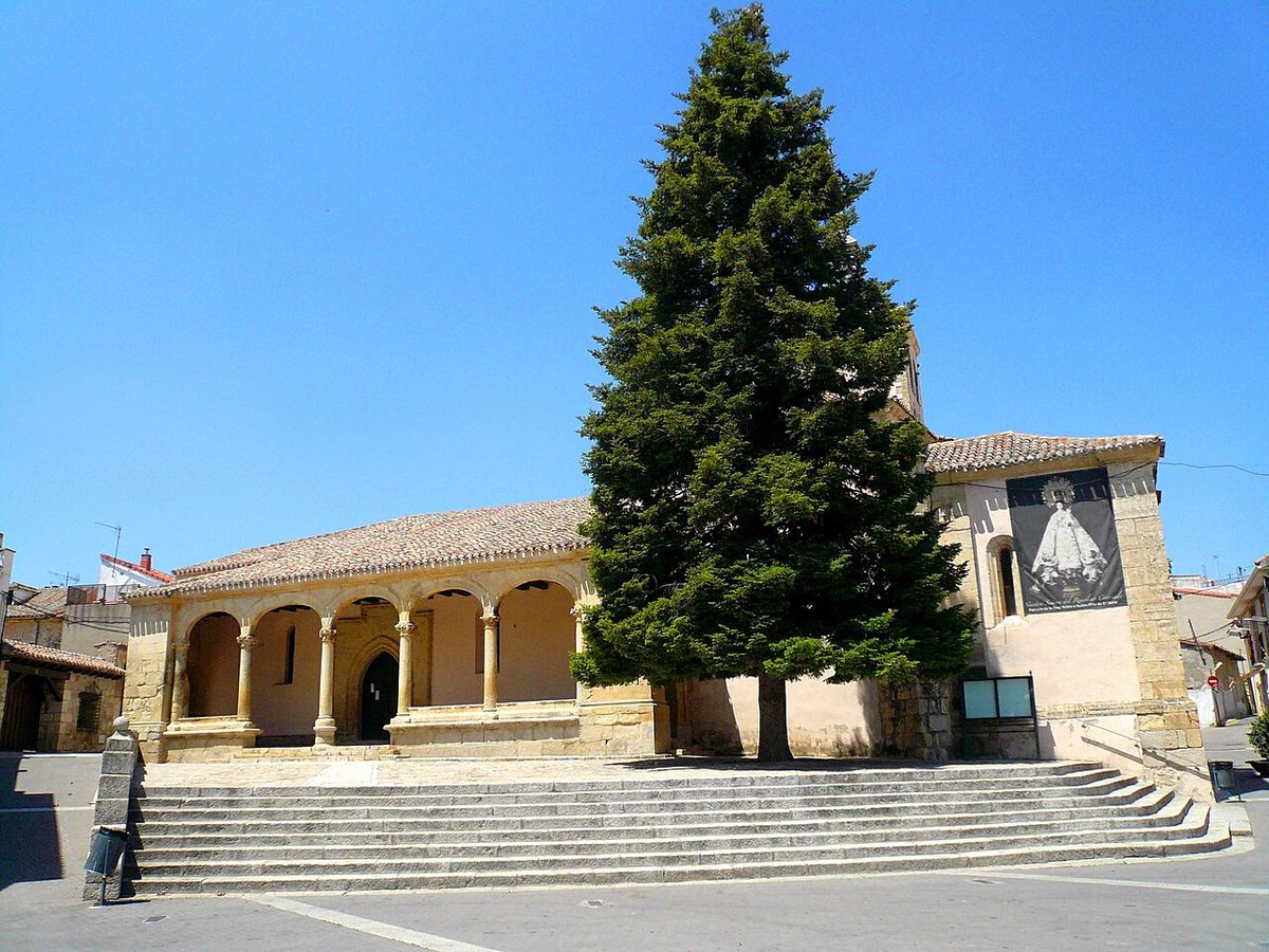
The church of San Miguel, built in the 16th century on top of an earlier structure, holds one of the old copies of the charter. Architecturally, it belongs to a restrained late Gothic style common in many villages in the region. Decoration is not the defining feature. Instead, its position matters most. The tower rises above the cluster of houses and, for centuries, served as a visible reference point for anyone approaching along the surrounding roads.
Casítos: stone shelters and seasonal herding
On the hills around Pedrezuela, small circular stone structures appear, known locally as casítos. The municipality preserves a considerable number of them, likely the highest concentration within the Community of Madrid.
Documents from the 16th century mention similar constructions under the name “haros”. They were used as shelters by shepherds travelling with transhumant flocks on their way to mountain pastures. These seasonal movements of livestock shaped much of the rural economy for generations.
The casítos are extremely simple. They are built with dry stone walls, without mortar, forming a circular plan just a few metres across. The entrance is low and usually oriented to the south, a practical choice to reduce exposure to prevailing winds.
A route links several of these shelters, crossing holm oak woodland and gentle hills. It is not a monumental trail, and in some sections it is not especially well signposted. The value lies elsewhere. Walking here offers a way to understand how the landscape functioned when transhumant grazing was still central to daily life, rather than something remembered in fragments.
Water in the valley: reservoir and earlier dam
The Pedrezuela reservoir now fills the Guadalix valley and has been part of Madrid’s water supply system since the second half of the 20th century. Its presence defines the landscape today, creating a wide expanse of water where the river once ran more narrowly.
Before this infrastructure, there was another attempt to regulate the river. The Presa del Mesto, built in the mid-19th century, was an early effort to channel water towards the capital. The project did not perform as expected and was only operational for a very short period. When water levels in the current reservoir drop, remains of that earlier stone construction can still be seen.
The surrounding area is included within protected spaces linked to the Natura 2000 network and designated zones for bird protection. It is not set up as a bathing spot or a large recreational complex. Instead, the environment consists of forest tracks, holm oak groves and stretches of shoreline where birds of prey and waterfowl are often observed.
A path runs around much of the reservoir’s perimeter. Many people follow it on foot or by bicycle, as the gradients are moderate and the terrain allows for a steady pace without major climbs.
Cabrito and continuity in the kitchen
Pedrezuela has long been associated with cabrito asado, roast kid goat. This connection goes back decades and is linked to its former position along the road connecting Madrid with the north of the peninsula. Travellers would stop here to eat, and the presence of several traditional ovens reflects that history.
The preparation follows the style typical of the northern part of the Madrid region: a wood-fired oven, a clay dish and milk-fed kid goat. It is straightforward cooking, with few variations. Alongside it, traditional desserts such as gachas dulces still appear on tables, made with flour, milk, aniseed and lemon.
Rather than a dish developed for visitors, it is a continuation of everyday cooking rooted in a livestock-based landscape.
Moving around Pedrezuela
Pedrezuela lies about 45 kilometres from Madrid, reached via the A-1 with an exit close to the town. There is no train station, so most arrivals are by road.
The urban centre can be covered quickly. From the church of San Miguel, the position of the village becomes clear, overlooking the valley and the flatter land that opens towards the south.
Those heading towards the casítos usually start from tracks that lead out towards the nearby hills on the edge of the town. From there, the terrain gradually shifts into the same mix of low rises and woodland where these stone shelters are scattered, still marking the patterns of movement that shaped Pedrezuela in earlier centuries.