Full Article
about Puentes Viejas
Municipality made up of four villages and three reservoirs; medieval heritage and nature
Hide article Read full article
A Municipality Made of Villages
Puentes Viejas appears on the map of the Sierra Norte of Madrid as a relatively new municipality, though its villages are much older. The administrative area was created at the start of the 21st century by merging several small settlements, including Mangirón, Cinco Villas, Paredes de Buitrago and Serrada de la Fuente, which had functioned independently for centuries. Together they now total just over seven hundred residents, spread across these separate communities.
The municipality stretches along the Lozoya valley and beside the Puentes Viejas reservoir, one of the historic dams in the water system that supplies Madrid. The original structure was built in the early 20th century and reshaped the landscape of this part of the sierra. What had once been a valley of orchards and open land became defined by still water and new roads that brought the area closer to the capital.
Roots in the Sierra Norte
To understand these villages, it helps to go back to the medieval repopulation of the Sierra Norte. After the Christian frontier stabilised in the 11th century, the territory came under the influence of Buitrago del Lozoya and its administrative community, known as a “comunidad de villa y tierra”, a system that organised surrounding rural areas from a central town. From there, small agricultural and livestock settlements were established along the slopes and valley crossings.
Many of today’s villages began as shepherd communities. Life depended on woodland resources, small dryland crops and the seasonal movement of herds along established drove roads. Isolation shaped daily life for centuries. Modern roads arrived late, and that slow pace helps explain why the urban layout remains so compact.
The church of San Pedro Apóstol reflects this mountain architecture. Built in stone masonry and topped with a simple bell gable, it dates in origin to the 16th century, though parts were altered later. It is not a grand monument, but it served as the parish centre for a small, scattered population.
Around it, the streets preserve stone houses with tiled roofs and thick walls designed for the cold winters of the sierra. There is no rigid urban plan. The layout follows the terrain and the old paths that once linked one village to another.
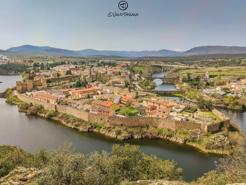
The name Puentes Viejas recalls the historic crossings over streams and over the Lozoya itself. Before dams and modern roads, these bridges were essential points for moving through the valley and connecting with Buitrago or the mountain passes.
Land Shaped by Water and Pasture
The landscape combines scrubland, holm oak woods and open grazing areas. In wetter spots, oak and ash trees appear. It is a territory shaped both by livestock activity and by the water of the Lozoya and its tributaries.
The reservoir introduces a clear contrast. Dry hillsides descend abruptly to calm shores, where people can now be seen fishing or walking along nearby paths. It is not a vast mountain lake, yet it changes the scale and feel of the valley.
Seasonal shifts are easy to notice. In spring, green tones dominate the meadows. By autumn, the vegetation turns ochre and the ground becomes covered with fallen leaves. Summer days can be dry, though the air often cools noticeably towards evening.
Paths Through the Valley
The routes around Puentes Viejas often follow older paths that once connected villages or led towards grazing land. Some ran alongside the Lozoya, while others climb into the surrounding hills.
Walking these paths gives a sense of how life was organised in this part of the Sierra Norte. Distances between villages are short, but the terrain forces detours around streams and ridges. This explains the historical importance of bridges and well-known crossing points used by local people.
In autumn, it is common to see people searching for mushrooms in the woodland. This is a long-standing practice in the area, though it requires familiarity with both the terrain and the species found there.
A Short Walk Around the Village
A brief visit usually centres on the main settlement and the church of San Pedro Apóstol. From there, the built-up area can be explored in a short time. The streets clearly show the features of mountain architecture: local stone, thick walls and buildings placed close together for protection against the cold.
With a little more time, it is worth heading towards the paths that descend into the Lozoya valley or towards the surroundings of the reservoir. Long routes are not necessary. Within minutes of leaving the village centre, the open landscape of the Sierra Norte comes into view.
Getting There and Understanding the Area
Puentes Viejas lies around seventy kilometres from Madrid and is reached by road, crossing the Sierra Norte towards the Lozoya valley.
It is important to remember that the municipality is made up of several separate settlements. Seeing just one does not give a full picture. Each village preserves part of the local history and the way of life that shaped this area of the sierra over many centuries.