Full Article
about Urraul Bajo
A farming valley watered by the Areta river; Artieda and its heritage stand out.
Hide article Read full article
Between Sangüesa and the Pre-Pyrenees
Urraul Bajo sits in the eastern part of Navarra, in the transition between the Sangüesa basin and the first ridges of the Pre-Pyrenees. It is not a single, compact settlement but a municipality made up of several small, scattered villages, with a population of around 330 people. That dispersed layout reflects an older way of organising rural life, where homes and farmland were spread across the valley rather than grouped tightly together.
The landscape explains much of this pattern. Ravines, gentle hills and cereal fields define the terrain, and each small settlement occupies a position that makes practical use of the land around it. Rather than a central village surrounded by fields, Urraul Bajo is a patchwork of inhabited spots connected by tracks and shared administration.
An Agricultural Landscape with Deep Roots
Records trace the area back to the Middle Ages, when these valleys were linked to the orbit of Sangüesa, one of the important towns of the former Kingdom of Navarra. From early on, the territory developed around agriculture. Small villages, separated by fields and low hills, allowed communities to make use of arable land while managing pasture and water sources.
That structure remains visible today. Urraul Bajo functions as a group of places that share both landscape and local government. The buildings reflect this history. Stone houses with tiled roofs and large doorways, designed for tools or livestock, point to an economy long based on cereal farming, with some vineyards and small-scale livestock.
Some façades carry simple coats of arms or dates carved into lintels. These details usually relate to renovations carried out in the 17th and 18th centuries, when many homes were expanded or rebuilt on earlier foundations. The marks of those changes are still easy to spot.
Everyday Architecture and the Shape of the Village
The main settlement is small and can be explored in a short walk. At its centre stands the parish church, as is typical in Navarra villages of this size. The building itself is restrained. Its importance lies less in architectural display and more in how it sits within the cluster of houses, linked to a square or small open space nearby.
The streets reveal practical solutions shaped by climate and agricultural life. Wide eaves protect walls from rain. Brick chimneys appear as later additions from more recent renovations. Attached corrals show how closely domestic and working spaces were once connected.
There is no attempt at a uniform look. Some houses are carefully preserved, while others have been altered over time. That mix offers a clear sense of how the village has evolved across the last century, without smoothing over the differences between old and new.
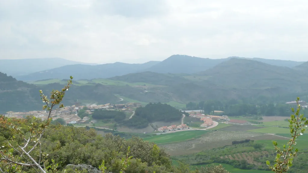
San Miguel and Reading the Landscape
A short distance away, on higher ground, stands the hermitage of San Miguel. Hilltop hermitages like this are common in Navarra. In some cases, they marked former parish boundaries or served as gathering points for specific celebrations.
From this position, the structure of the valley becomes easier to understand. The cluster of houses sits between open fields and small ravines where vegetation grows more densely. The colours shift noticeably through the year. Spring brings intense green tones, while the ripening of cereal fields turns the land golden. Winter leaves a much barer scene.
The site is not set up as a formal viewpoint and there is no special signage. It is simply one of the places where the layout of the valley can be read most clearly.
Walking the Surroundings
Agricultural tracks make it easy to leave the village on foot. These routes are used by tractors and by residents working their land. The terrain is generally gentle, although some stretches climb towards the low hills that frame the valley.
Anyone planning a longer walk should carry a map or a recorded track. Many paths branch off and signposting is not always present. Even so, the landscape remains quite open, and finding one’s bearings is usually straightforward.
The fields are more active early in the day or towards evening. At those times, it becomes easier to notice the birds that frequent cultivated land and the edges of ravines.
Practical Notes for a Visit
Urraul Bajo works best as a stop within a wider route through the Sangüesa area and the Navarrese Pre-Pyrenees. The built-up area can be seen quickly. The interest lies in walking beyond it and observing how villages and farmland are arranged across the valley.
Services are not always available within the municipality itself, so it is sensible to bring water and something to eat if planning to spend several hours in the area. After rain, agricultural tracks can become muddy, and it is important not to block access to fields when using a car.
From Pamplona, the route follows roads leading towards Sangüesa before continuing along narrower regional roads. The journey is calm, with bends and light traffic. Once in Urraul Bajo, leaving the car in the village and continuing on foot offers the clearest sense of how this valley works and how it has been shaped over time.