Full Article
about Legutio (Villarreal de Álava)
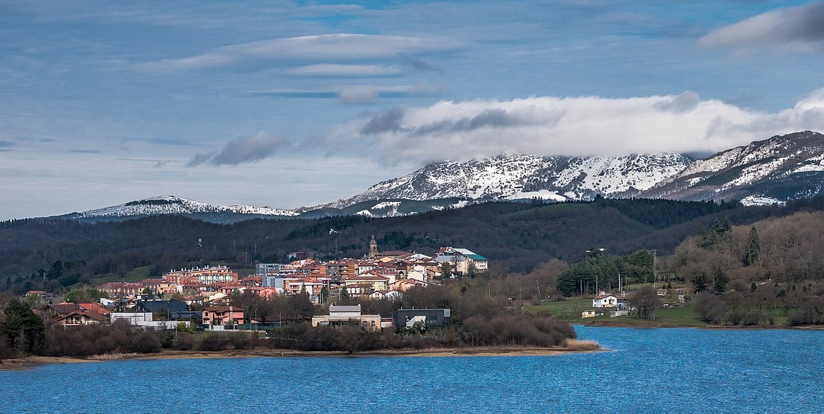
Deep green, farmhouses and nearby mountains with trails and viewpoints.
Ocultar artículo Leer artículo completo
The reservoir appears first. One moment you're winding through apple orchards and red-shuttered farmhouses, the next the road drops and Legutio's lake spreads beneath you like a dropped bolt of silk. It's not the Atlantic, though you can smell salt on the wind some days. It's Urrunaga, a man-made sheet of water that locals still call "the swamp" even though holiday apartments now cluster on its southern shore.
This is how the village announces itself: not with medieval towers or a cathedral spire, but with a body of water that doubles as both playground and workplace. Fishermen cast for perch and carp along the eastern bank while families from Vitoria-Gasteiz twenty minutes away unload cool-boxes onto picnic tables at Zabalain recreational area. Turn up after two o'clock on a Saturday and you'll hear more Basque than Spanish, more Spanish than anything else. English is absent enough to feel conspicuous.
Legutio sits at 560 metres above sea level where the Alava plains start their climb towards the Gorbeia massif. The geography explains the weather: mornings arrive wrapped in valley mist that burns off by eleven, replaced by afternoon breezes that can whip the reservoir into proper waves. Even in July you'll want a fleece by nine o'clock. The village proper houses barely 1,500 souls, though the wider municipality stretches to include scattered hamlets and isolated caseríos – those distinctive Basque farmsteads with their wooden balconies and straw-loft doors big enough to drive a tractor through.
The Lake Rules Everything
Urrunaga reservoir dominates daily life in ways that only become apparent after a day or two. The water level drops dramatically in late summer, exposing red mud beaches that local kids use for BMX jumps. When autumn rains arrive, the same spots disappear beneath three metres of water. Road signs warning of potential flooding aren't decorative; 2018's storms closed the main street for three days.
The lake's personality shifts with the seasons. May brings hawthorn blossom along the shoreline and the first serious barbecues. By August, Spanish number plates outnumber Basque ones as families claim their annual fortnight in the holiday flats. October turns the surrounding oak and beech woods copper, and the reservoir becomes a mirror for colours that would make a Cumbrian postcard jealous. Winter strips everything back to grey water, black trees, and the occasional heron.
Swimming is tolerated rather than encouraged. There's no lifeguard, no blue flag, and the bottom shelves sharply into weed beds that tangle unwary feet. Locals favour the small cove near the sailing club where a concrete slipway provides easy access. bring footwear – the lake bed's stony and nobody sells aqua-shoes locally. The water reaches 22°C if you're lucky, 19°C if you're not.
What Passes for a Centre
Legutio's heart is Plaza Mayor, a rectangular space that functions more as car park than plaza except during fiestas. The parish church of San Juan Bautista anchors one side; its 16th-century tower looks modest until you notice the gargoyles are vomiting water onto passers-by during storms. Inside, baroque altarpieces compete for space with modern saints that seem airlifted in from a different century entirely.
Opposite stands Asador Arkupe, the village's culinary claim to fame. Their txuleta – a Basque rib-steak cooked so rare it practically moos – arrives on plates the size of satellite dishes. One portion feeds two hungry walkers comfortably, though solo diners have been known to attempt the challenge. Book ahead at weekends; half of Vitoria seems to descend for Sunday lunch. For lighter appetites, Bar Kurutz serves pintxos that change daily. The goat's cheese and caramelised onion version has converted declared seafood-haters, though traditionalists plump for tortilla squares drizzled with paprika oil.
The shopping options won't trouble HMRC's duty-free allowances. Two small supermarkets stock everything from tractor oil to tortilla flour, both closing religiously between two and five. Need a swimsuit, sun-cream, or souvenir tea-towel? You're driving to Vitoria. This isn't oversight – it's deliberate. Legutio functions as what Spaniards call a "pueblo de paso," a place you pass through rather than base yourself, unless you're prepared to embrace its rhythms.
Hill Country Starts Here
Behind the village proper, tracks climb through beech woods towards Gorbeia Natural Park. The mountain itself – at 1,482 metres the Basque Country's most climbed peak – sits eight kilometres away as the crow flies. The road route doubles that distance and adds 800 metres of ascent, enough to separate casual strollers from serious hikers.
Local walking starts gentler. A forty-minute climb from the cemetery brings you to Ermita de San Cristóbal, a 17th-century chapel perched above the reservoir. The path's stone-slabbed but slippery when wet; trainers suffice in dry weather, boots essential after rain. The payoff is a view south across the Alava plains that makes the effort worthwhile. On clear days you can pick out Vitoria's cathedral spire; more often, clouds boil up the valley and swallow everything below.
Further options proliferate for those with transport. The PR-BI 102 trail circles the reservoir's northern shore through oak plantations and past abandoned farmsteads. Total distance is 12 kilometres with negligible ascent – perfect for working off that txuleta. Mountain bikers favour the forest tracks climbing towards Zuia's high pastures, though the gradients punish anyone who forgot this is mountain country. Road cyclists appreciate the secondary roads linking Legutio with neighbouring villages; traffic is light but the hills roll continuously. There's no flat terrain here – the valley floor is lake.
Seasons of Mud and Miracles
Spring arrives late at this altitude. April can still bring morning frost, though wild daffodils push through roadside banks regardless. Local fiestas cluster around summer solstice – San Juan in late June involves bonfires so large the fire brigade stands by with pump trucks. August's Assumption weekend sees the population triple as extended families claim their ancestral houses for three days of eating, drinking, and arguing about politics.
Autumn delivers the year's finest walking weather. Mornings start crisp, afternoons warm into the low twenties, and the reservoir lies still enough to photograph reflections of beech woods turning copper. Mushroom hunters disappear into Gorbeia's higher reaches; permits are required but nobody checks unless you're filling industrial-sized baskets. The village bakery starts selling talo – cornflatbreads cooked on hotplates – traditionally served with txistorra sausage and washed down with cider from Zelaia, five minutes up the road.
Winter strips everything back to essentials. Bars fill with farmers discussing rainfall statistics while their dogs sprawl across doorways. The reservoir can freeze along shallow edges; locals claim this happened three times during the 1980s though photographic evidence remains elusive. When snow arrives – usually January – the mountain road closes and Legutio becomes what it always threatens to be: a village at the end of the road.
Getting Here, Getting Away
Bilbao's airport sits seventy-five minutes away via the A-8 and AP-68 motorways. Hire cars are essential – public transport reaches Legutio three times daily on weekdays, zero times Sunday. Vitoria's small airport is closer at twenty minutes but offers no UK flights; Biarritz provides an alternative entry point for those combining Basque coast and mountains. Driving times from Santander's ferry port run three hours, doable for motorists arriving on the Portsmouth route.
Accommodation clusters around the lake rather than the village centre. Apartamentos Rurales Urrunaga offer two-bedroom flats with kitchens from €85 per night outside peak season. The single three-star hotel, Arratz-Akur, sits five minutes walk from the plaza – rooms are functional rather than luxurious, breakfast features tortilla and strong coffee. Campsites exist at Zabalain for those travelling with tents, though facilities are basic and weekend noise levels rise with Spanish family groups.
The honest assessment? Legutio works as a pause rather than a destination. Pair it with Vitoria's galleries and tapas bars, or use it as a base for Gorbeia hiking when the coast's too hot. Come expecting lavender-hanging lanes and you'll leave disappointed. Arrive prepared for lake views, steak the size of your head, and the smell of woodsmoke on autumn air, and you'll understand why locals never bothered building that bypass.