Full Article
about Castril
Spectacular mountain village with a famous walkway over the river; gateway to the Sierra de Castril Natural Park, a landscape of rock and water.
Hide article Read full article
A Village Shaped by Stone
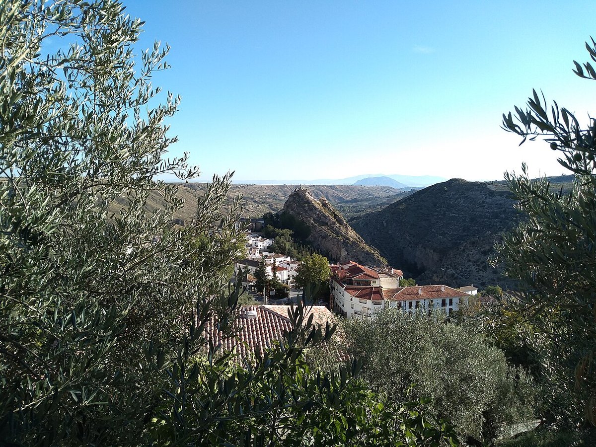
Tourism in Castril begins with its setting. The village rises on a rocky outcrop at around 890 metres above sea level, at the northern edge of the province of Granada, close to the mountain ranges that separate Andalucía from Murcia and Castilla‑La Mancha. That rock, visible from almost every approach road, determines everything: the layout of the old town, the constant slopes and even the way the village faces the valley of the River Castril.
The geography is abrupt. Dry hillsides descend towards small cultivated patches along the river, while to the north pine forests signal the start of the Parque Natural de la Sierra de Castril. This is a landscape that has seen relatively little transformation, partly because the surrounding mountains have always set clear limits to expansion. The result is a small municipality that still maintains a fairly direct relationship with its natural surroundings.
Castril does not spread outwards so much as it clings to its rock. The village and the landscape are inseparable, and understanding that connection is key to understanding the place itself.
Climbing Through the Historic Centre
Castril is explored on foot, and almost always uphill. The streets begin in the valley and climb steadily towards the rock where the old fortress once stood. That ascent explains the irregular layout of the historic centre: narrow alleyways, short but persistent inclines and small improvised viewpoints appearing between whitewashed houses.
At one of the central points of the village stands the Iglesia de Nuestra Señora de los Ángeles. The present building dates from the 16th century and was later altered. Beyond its architecture, its urban role is what stands out. The square around it continues to function as a daily meeting place, anchoring local life much as it has for centuries.
Above the houses lie the remains of the old castle, of Islamic origin. Little survives today, yet the location tells its own story. The rock dominates the valley and controls the natural passage towards the neighbouring sierras. The climb to the top is not long, although the gradient is noticeable, particularly in the hotter months. From here, the relationship between settlement and territory becomes clear: the river below, the cultivated patches along its banks and the pine-covered slopes further north.
Among the houses of the historic centre is the Casa de los Capitanes Viejos. It is one of the few examples of grander domestic architecture in Castril and a reminder that the village once held a certain administrative importance within the wider district in past centuries. Its presence breaks the rhythm of simpler façades and hints at a more complex local history.
The Birth of the River Castril
A short distance from the village centre lies one of Castril’s most recognised natural sites: the Nacimiento del río Castril, within the natural park. Here the water emerges directly from limestone rock, creating a small system of waterfalls and pools surrounded by riverside vegetation.
The scene is defined by the contrast between stone and water. Clear streams slip over pale rock, gathering in shaded pools before continuing down towards the valley. It is one of the municipality’s best-known spots. On quiet days the area retains a notable sense of stillness, though on public holidays and weekends it can attract more visitors than might be expected in a mountain setting.
The Nacimiento is not presented as a dramatic spectacle, but as a place where the geological character of the region becomes tangible. The same limestone that forms the cliffs and outcrops above the village is responsible for these springs, shaping both landscape and settlement.
Walking in the Sierra de Castril
The mountains surrounding the village were declared a natural park in recognition of their ecological value and the good condition of their forests and waterways. The relief is formed by calares, high limestone plateaus, ravines and expanses of pine forest that vary significantly with altitude.
Around the river’s source there are marked footpaths that allow visitors to follow the valley and approach the springs. These routes offer a way of understanding the terrain at close range, tracing the course of the water as it leaves the rock and begins its descent.
Higher up, there are longer routes with greater changes in elevation. In these upper areas the landscape becomes more open and stony, with a harsher feel than the greener valley below. Conditions shift with height, and so does the sense of scale. Before setting out, it is advisable to seek information, as access to certain areas is regulated.
The limestone walls near the river have also drawn climbing enthusiasts for years. The compact rock and vertical cliffs create terrain appreciated within this activity. Their presence adds another dimension to the landscape, where geological forms serve both ecological and recreational purposes.
Cooking from the Sierra
Local cuisine reflects the climate and the area’s livestock traditions. In colder months especially, dishes such as migas, gachas pimentonás and cordero segureño frequently appear on village tables. Migas, a dish based on breadcrumbs or flour, and gachas pimentonás, flavoured with paprika, speak of practical cooking rooted in rural life. Cordero segureño refers to lamb from the Segura area, long associated with the surrounding sierras.
Olive oil from the district accompanies many simple preparations that rely more on the quality of the ingredients than on elaborate techniques. The food mirrors the landscape: direct, shaped by necessity and closely tied to local production.
Fiestas and Everyday Rhythm
The fiestas in honour of Nuestra Señora de los Ángeles, usually held in August, mark one of the liveliest moments of the year. For several days, processions, neighbourhood gatherings and popular events fill the streets of the old quarter. The same squares and steep lanes that feel quiet for much of the year become busier, animated by shared celebration.
Outside these dates, Castril keeps a calm pace. Daily life unfolds between the river and the sierra, the two elements that explain almost everything encountered while walking through the village. The rock overhead, the water below and the forests beyond form a setting that has shaped its streets, its food and its festivities.
Seen slowly, the landscape tells much of Castril’s story. The stone outcrop, the Islamic castle remains, the church square and the river’s source are not isolated attractions but parts of a single geography. In Castril, the terrain is not a backdrop. It is the framework within which the village continues to live.